1800s (19th Century) Maps of Plaquemines Parish, Louisiana
Explore 13 historic maps of Plaquemines Parish from the 1800s (19th Century). These maps offer a rare glimpse into what life looked like during the 1800s — showing old roads, neighborhoods, homes, and landmarks that have changed or disappeared over time.
Whether you're researching your family's past, planning a metal detecting trip, or studying how Plaquemines Parish's landscape evolved across the 1800s, these high-resolution maps are a powerful tool for exploring the history of this region.
- Focus on a specific era: All maps on this page are from the 1800s, giving you a focused view of this time period.
- See what’s changed: Compare century-old streets, trails, and buildings to today's modern landscape using overlays and satellite layers.
- Research with precision: Use these maps for genealogy, historical research, land use analysis, or educational projects.
- View, download, or print: Maps are fully viewable online in high resolution, and can be downloaded or printed for your own records.
Start exploring Plaquemines Parish's history through authentic maps from the 1800s. This is your window into the past.
Plaquemines Parish, LA maps
(13)- 1891 Map of Pointe a La Hache
 1891 Pointe a La Hache1891 Print · USGSCoastal Plaquemines Parish and the Mississippi River delta appear here in the early 1890s, revealing a landscape of narrow riverfront plantations and rail-connected settlements. Researchers can trace the path of the New Orleans Ft Jackson and Grand Isl Railroad through historic sites like Pt A La Hache, Myrtle Grove, and Empire Mills.
 - 1891 Map of New Orleans
 1891 New Orleans1891 Print · USGSGreater New Orleans and the surrounding bayous are captured in the late Victorian era as the city's rail and canal networks expanded. Researchers can trace the development of riverfront communities like Gretna and Algiers or locate now-obscure landings such as Jesuit Bend and Amesville.5 unique versions available
 - 1892 Map of Barataria
 1892 Barataria1892 Print · USGSCoastal Jefferson and Plaquemines parishes appear in the late nineteenth century as a sprawling network of marshlands and navigable bayous. Researchers can trace the early rail influence of the N. O. F. J. & G. I. R. R. and locate family landmarks like John the Fool Island and the settlement of Barataria.3 unique versions available
 - 1892 Map of Quarantine
 1892 Quarantine1892 Print · USGSThe lower Mississippi Delta in the 1890s appears as a fragile network of river settlements and sprawling bayous. Genealogists and historians can trace family locations at Guyot Settlement, the Quarantine station, and Buras Settlement.5 unique versions available
 - 1892 Map of St. Bernard
 1892 St. Bernard1892 Print · USGSCoastal Louisiana in the early 1890s is captured here as a landscape of river-bend settlements and expanding rail lines. Genealogists and historians can trace family land and depots at Poydras, St Bernard, and the New Orleans and Gulf Railroad stops.4 unique versions available
 - 1892 Map of Pointe a La Hache, 1898 Print
 1892 Pointe a La Hache1898 Print · USGSThe lower Mississippi delta in the 1890s reveals a ribbon of riverfront settlements and competing rail lines. Genealogists and historians can trace family-named sites like Savoie and Nero or locate the Empire Mills (Martin) near Pt. A La Hache.
 - 1893 Map of East Delta
 1893 East Delta1893 Print · USGSThe tip of the Mississippi River delta comes alive in the 1890s, where river pilots and maritime outposts guarded the gateway to the Gulf. Genealogists and historians can trace the foundations of Port Eads and Balize, or locate the Old Spanish Magazine and the early South Pass Light.6 unique versions available
 - 1893 Map of La Fortuna
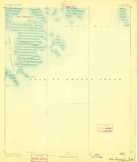 1893 La Fortuna1893 Print · USGSSt. Bernard Parish’s coastal marshes and sounds are documented here in the late nineteenth century before major modern shoreline changes. Trace the original hydrology of the bayous including Bayou Terre Aux Boeufs, Lake La Fortuna, and Eloi Bay.3 unique versions available
 - 1893 Map of Forts
 1893 Forts1893 Print · USGSThe strategic lower Mississippi delta comes into focus in the 1890s, when river defense and delta navigation were paramount. Historians can trace the exact footprints of Fort Jackson and Fort St. Phillip or locate old waterways like Lucas Canal.4 unique versions available
 - 1893 Map of Shell Beach
 1893 Shell Beach1893 Print · USGSSt. Bernard Parish in the 1890s shows a landscape of coastal settlements and fishing villages connected by rail and water. You can trace the Shell Beach Railroad to its coastal terminus and find old sites like Florissant, Yscloskey, and St. Malo.3 unique versions available
 - 1893 Map of Fort Livingston
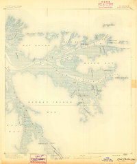
 1893 Fort Livingston1893 Print · USGSThe Louisiana coast in the early 1890s is captured here as a sprawling network of tidal bayous and strategic passes. Local historians can trace maritime markers like Ft. Livingston and the Light on Grand Isle amid a maze of islands.3 unique versions available
 - 1893 Map of Dime, 1901 Print
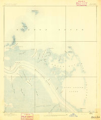
 1893 Dime1901 Print · USGSThe Plaquemines parish riverfront and its vast coastal marshes appear here in the final decade of the nineteenth century. Genealogists can trace the river settlements of Dime and Happy Jack along the N. O. Ft. J. & G. I. R. R. line.2 unique versions available
 - 1893 Map of West Delta, 1904 Print
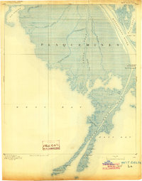 1893 West Delta1904 Print · USGSThe mouth of the Mississippi River in the 1890s reveals a maritime landscape built around the shifting mudflats and deep-water channels of the delta. Maritime historians and genealogists can trace the locations of the Custom House, the Pilot Lookout, and various aids to navigation such as the South West Pass Light.3 unique versions available
End of results
Showing maps 1-13 of 13
Top cities of Plaquemines Parish
Frequently asked questions
- What are the different types of historical maps available for Plaquemines Parish?
- What is the oldest map of Plaquemines Parish?
- Where can I purchase historical maps of Plaquemines Parish for my home or office?
- Where can I download high-res historical maps of Plaquemines Parish?
- Are there historical topographic maps available for Plaquemines Parish?
- Is there historical aerial imagery available for Plaquemines Parish?
- Where are historical maps of Plaquemines Parish sourced from?