1900s (20th Century) Maps of Plaquemines Parish, Louisiana
Explore 184 historic maps of Plaquemines Parish from the 1900s (20th Century). These maps offer a rare glimpse into what life looked like during the 1900s — showing old roads, neighborhoods, homes, and landmarks that have changed or disappeared over time.
Whether you're researching your family's past, planning a metal detecting trip, or studying how Plaquemines Parish's landscape evolved across the 1900s, these high-resolution maps are a powerful tool for exploring the history of this region.
- Focus on a specific era: All maps on this page are from the 1900s, giving you a focused view of this time period.
- See what’s changed: Compare century-old streets, trails, and buildings to today's modern landscape using overlays and satellite layers.
- Research with precision: Use these maps for genealogy, historical research, land use analysis, or educational projects.
- View, download, or print: Maps are fully viewable online in high resolution, and can be downloaded or printed for your own records.
Start exploring Plaquemines Parish's history through authentic maps from the 1900s. This is your window into the past.
Plaquemines Parish, LA maps
(184)- 1932 Map of New Orleans NE
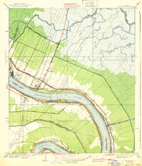
 1932 New Orleans NE1932 Print · USGSNew Orleans and the West Bank riverfront are seen in the early thirties, showing the dense grid of the French Quarter and the sprawling medical and university districts. Researchers can find old landmarks like St Louis Cathedral, the Custom House, and Gretna High School.
 - 1932 Map of New Orleans SE
 1932 New Orleans SE1932 Print · USGSThe Mississippi River delta south of the city was a maze of bayous and new industrial canals in the early 1930s. Genealogists and historians can trace riverside settlements like Bertrandville and Oakville or locate the early Wedell-Williams Landing Field.
 - 1935 Map of Taylor Pass
 1935 Taylor Pass1935 Print · USGSCoastal St. Bernard Parish is captured in the mid-1930s just as aerial photography began to transform maritime mapping. Researchers can trace the exact 1935 shoreline and marsh islands including Bird, Sable, and the winding Blackjack Bayou.
 - 1935 Map of Port Sulphur
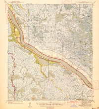
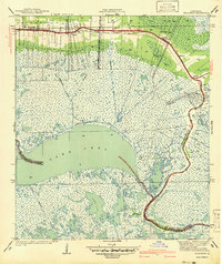
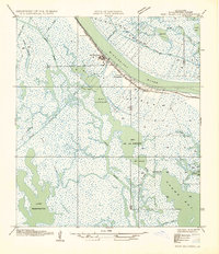 1935 Port Sulphur1935 Print · USGSCoastal Plaquemines Parish comes alive in the mid-1930s, where riverfront settlements like Port Sulphur and Homeplace PO cling to the Mississippi's natural levee. Genealogists and historians can trace the early rail-and-road corridor or explore the complex marshlands surrounding Lake Washington and Milan Ch.
 - 1935 Map of Garden Island Pass
 1935 Garden Island Pass1935 Print · USGSCoastal Plaquemines Parish is captured in the mid-1930s as the river meets the sea through a network of shifting passes. Trace the historic waterways and marshy landmarks like Old Balize Bayou, Southeast Pass, and Francois Bend.
 - 1935 Map of Lake Athanasio
 1935 Lake Athanasio1935 Print · USGSCoastal St. Bernard Parish was a complex network of marsh and open water in the mid-1930s, just as aerial surveying began to map the delta in detail. Researchers can trace the historic shoreline from Coon Nest I down to Mozambique Pt, including the named waters of Seven Dollar Bay.
 - 1935 Map of Delacroix
 1935 Delacroix1935 Print · USGSCoastal St. Bernard Parish and its marshland communities appear in the mid-1930s as a complex network of bayous, canals, and rail. Researchers can trace the extension of the Louisiana Southern railroad to fishing outposts like Delacroix and Reggio.
 - 1935 Map of Bastian Bay
 1935 Bastian Bay1935 Print · USGSCoastal Plaquemines Parish is captured here during the mid-1930s, revealing an intricate network of wetlands and barrier islands. Researchers can trace the early footprints of marsh settlements like Bastian and Wise or follow the course of the Grand Bayou.
 - 1935 Map of South Pass
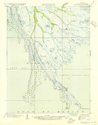 1935 South Pass1935 Print · USGSThe Mississippi River Delta reaches into the Gulf during the 1930s, showing a landscape of delicate marshland and engineered channels. Local historians can trace the maritime operations at Port Eads and locate coastal landmarks like South Pass L H and the Pilot Sta.3 unique versions available
 - 1935 Map of Lake Calebasse
 1935 Lake Calebasse1935 Print · USGSCoastal Louisiana marshlands appear as a dense network of bayous and lagoons in the mid-1930s, documenting the intricate boundary of St. Bernard and Plaquemines Parishes. Researchers can trace the winding Bayou Terre Aux Boeufs and find isolated landmarks like Coquille and Greaseboat Island.
 - 1935 Map of Bay Ronquille
 1935 Bay Ronquille1935 Print · USGSCoastal Plaquemines Parish is documented in the mid-1930s as a labyrinth of tidal marshes and early industrial development. Researchers can trace the early footprint of the Grande Ecaille Oil Field or locate historic coastal points like Pt Cheniere Ronquille and Grande Terre.
 - 1935 Map of Lake Batola
 1935 Lake Batola1935 Print · USGSCoastal Plaquemines Parish appears as a dense network of marsh and open water in the mid-1930s, prior to extensive modern delta erosion. Researchers can trace the original shoreline and early fishing landmarks like Shrimp Lagoon, Lake Batola, and Alligator Pass.
 - 1935 Map of Tropical Bend
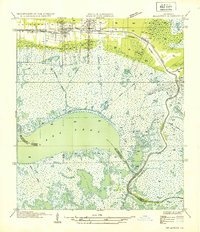
 1935 Tropical Bend1935 Print · USGSThe Plaquemines Parish marshlands are captured here in the mid-1930s, showing the early infrastructure of the Mississippi Delta. Researchers can trace the riverfront rail line of the Louisiana Southern Railroad and the settlements at Empire and Nairn.
 - 1935 Map of Wilkinson Bay, 1954 Print
 1935 Wilkinson Bay1954 Print · USGSCoastal Plaquemines Parish is captured in the mid-1930s, showing a labyrinthine landscape of marsh and water where the boundary with Jefferson Parish was still indefinite. Genealogists and historians can locate isolated delta outposts like Manila Cabinash P O and Camp Dewey.
 - 1939 Map of Shell Beach
 1939 Shell Beach1939 Print · USGSCoastal St. Bernard Parish is captured here in the late thirties, showing a landscape defined by tidewater bayous and early fishing settlements. Genealogists and local historians can trace the foundations of Alluvial City and Yscloskey or locate the site of Old Ft Beauregard.
 - 1939 Map of New Orleans East
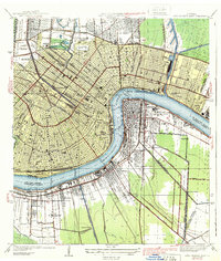 1939 New Orleans East1939 Print · USGSThe crescent city and its surrounding river parishes are captured in the late 1930s, showing New Orleans' transition into a modern port and educational hub. Genealogists can trace family roots through neighborhoods like Algiers and Arabi, or locate ancestors in St Louis Cem and Metairie Cemetery.3 unique versions available
 - 1939 Map of Chalmette
 1939 Chalmette1939 Print · USGSSt. Bernard Parish during the late 1930s reveals a world of riverfront plantations and growing rail corridors along the Mississippi. Genealogists and local historians can trace early settlements like Versailles and Meraux, or locate landmarks such as the Chalmette Nat Cem and Sinclair Ch.3 unique versions available
 - 1939 Map of Pointe a La Hache, 1941 Print
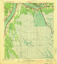
 1939 Pointe a La Hache1941 Print · USGSCoastal Plaquemines Parish centers on the riverbank communities of the late thirties, when the local economy was tied to the water and the rail. Researchers can trace the legacy of family settlements and rural institutions like the Deer Range Cem, St Jude Sch, and the rail lines at Pte Celeste.2 unique versions available
 - 1940 Map of Belle Chasse
 1940 Belle Chasse1940 Print · USGSCoastal Louisiana during the late 1930s is defined here by its intricate canal systems and riverside rail hubs. Trace the local economy through the Sea Train Terminal at Belle Chasse or the marshland paths near Tigers Ridge and Lake Lery.
 - 1940 Map of Bertrandville
 1940 Bertrandville1940 Print · USGSCoastal Louisiana at the start of the 1940s reveals a world of riverfront settlements and canal-driven industry. Genealogists and historians can trace the foundations of Bertrandville, locate St Johns Ch, and find long-standing landmarks like Woodlawn Sch along the Mississippi River.
 - 1941 Map of Black Bay
 1941 Black Bay1941 Print · USGSCoastal Plaquemines Parish and St. Bernard Parish are shown in detail at the end of the 1930s, when river life and marsh navigation defined the region. Researchers can locate riverfront settlements like City Price and Happy Jack or trace the waterways of Lake Coquille and Petain Lagoon.
 - 1941 Map of Empire
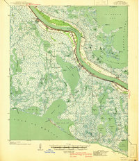 1941 Empire1941 Print · USGSPlaquemines Parish comes to life in this pre-war survey of the Mississippi River delta as it transitions into the Gulf. Genealogists and historians can trace the riverfront rail line through Port Sulphur and Buras, or locate landmarks like Pt Pleasant Cem and Swartze Sch.
 - 1941 Map of Delacroix
 1941 Delacroix1941 Print · USGSCoastal St. Bernard Parish was a world of water and marsh during the late 1930s and early 1940s. Genealogists and local historians can trace the string of settlements along the bayou from St Bernard down to Delacroix, while mapping old waterways like the Magnolia Canal and Howards Ditch.
 - 1941 Map of Barataria
 1941 Barataria1941 Print · USGSCoastal Jefferson Parish appears at the dawn of the 1940s, where the Mississippi River meets a vast network of bayous and wetlands. Genealogists can trace family roots in Barataria and Jesuit Bend, or locate historic local landmarks like Fisher Sch No 1 and the Lafitte P O.
 - 1941 Map of Shell Beach
 1941 Shell Beach1941 Print · USGSSt. Bernard Parish at the dawn of the 1940s reveals a coastal world of rail-connected fishing outposts and historic fortifications. Genealogists and local historians can trace the foundations of Shell Beach, the Old Bayou Railroad Grade, and the site of Old Ft Beauregard.2 unique versions available
Showing maps 1-25 of 184
Top cities of Plaquemines Parish
Frequently asked questions
- What are the different types of historical maps available for Plaquemines Parish?
- What is the oldest map of Plaquemines Parish?
- Where can I purchase historical maps of Plaquemines Parish for my home or office?
- Where can I download high-res historical maps of Plaquemines Parish?
- Are there historical topographic maps available for Plaquemines Parish?
- Is there historical aerial imagery available for Plaquemines Parish?
- Where are historical maps of Plaquemines Parish sourced from?