1960s Maps of Maryland
Explore 74 historic maps of Maryland from the 1960s. These maps offer a rare glimpse into what life looked like during the 1960s — showing old roads, neighborhoods, homes, and landmarks that have changed or disappeared over time.
Whether you're researching your family's past, planning a metal detecting trip, or studying how Maryland's landscape evolved across the 1960s, these high-resolution maps are a powerful tool for exploring the history of this region.
- Focus on a specific era: All maps on this page are from the 1960s, giving you a focused view of this time period.
- See what’s changed: Compare century-old streets, trails, and buildings to today's modern landscape using overlays and satellite layers.
- Research with precision: Use these maps for genealogy, historical research, land use analysis, or educational projects.
- View, download, or print: Maps are fully viewable online in high resolution, and can be downloaded or printed for your own records.
Start exploring Maryland's history through authentic maps from the 1960s. This is your window into the past.
Maryland maps
(74)- 1961 Map of Eastville
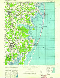
 1961 Eastville1961 Print · USGSThe Eastern Shore and Outer Banks are captured here in the mid-twentieth century, showing a maritime landscape of lighthouses, rail-linked towns, and naval outposts. Researchers can trace the Pennsylvania Railroad through Parksley or locate historical sites like Chincoteague Field Naval Auxiliary Air Station and Tangier Island.
 - 1961 Map of Washington
 1961 Washington1961 Print · USGSThe mid-Atlantic region in the late fifties is presented in remarkable detail, from the Blue Ridge foothills to the Chesapeake Eastern Shore. Researchers can trace historic river landings and military sites like Mount Vernon, Fort Belvoir, and Point Lookout.2 unique versions available
 - 1961 Map of Baltimore
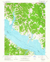
 1961 Baltimore1961 Print · USGSMaryland and Pennsylvania are captured at a mid-century peak of industrial and military expansion. Genealogists and historians can trace rail corridors like the Western Maryland Ry or locate regional landmarks such as Camp Detrick and Kent Island.
 - 1961 Map of Ocean City
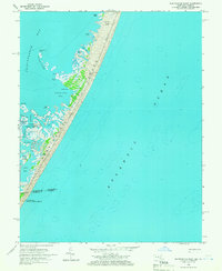
 1961 Ocean City1961 Print · USGSThe Maryland and Delaware coastlines come alive in this mid-century survey of the barrier islands and quiet inland towns. Genealogists and historians can trace the early layout of Ocean City and Berlin, or locate vanished rail stops along the Philadelphia Wilmington and Baltimore RR.
 - 1961 Map of Salisbury
 1961 Salisbury1961 Print · USGSThe Delmarva Peninsula comes into focus in the early sixties, showing the vital road and rail networks connecting the Chesapeake to the Atlantic. Genealogists and historians can trace family-named landings and coastal landmarks from Crisfield to the Brandywine Shoal Lighthouse.
 - 1961 Map of Cumberland
 1961 Cumberland1961 Print · USGSThe tri-state highlands of Maryland, West Virginia, and Pennsylvania are shown in the mid-twentieth century as a complex landscape of ridges and river valleys. Researchers can trace the winding Potomac River and find old rail-and-river towns like Cumberland, Keyser, and Morgantown.
 - 1962 Map of Heathsville
 1962 Heathsville1962 Print · USGSThe Northern Neck of Virginia is captured here at mid-century, showing the crossroads of Heathsville and the tidewater settlements along the Potomac. Genealogists can locate family landmarks like Sissons Corner, Downings Corner, and historic congregations at St Stephens Ch.
 - 1962 Map of Cumberland
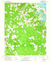
 1962 Cumberland1962 Print · USGSThe central Appalachians meet at the height of the mid-century industrial era, showing the rugged topography between Morgantown and Winchester. Genealogists can trace family lands near Fort Necessity or along the vital Baltimore & Ohio RR corridors.
 - 1963 Map of Belair
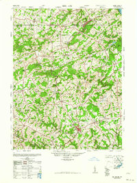 1963 Belair1963 Print · USGSHarford County and the Pennsylvania border are shown just after the war, when the Maryland and Pennsylvania RR still served these communities. Genealogists can locate family-named landmarks like the Broad Creek Meeting House, the Wheeler School, and St Ignatius Church.
 - 1963 Map of Hollywood, 1964 Print
 1963 Hollywood1964 Print · USGSCoastal St. Mary's County in the early sixties reveals a landscape of tidal creeks and deep-rooted community landmarks. Researchers can trace family sites like Our Ladys Chapel, follow the U S Government Railroad, or locate the old St Cuthbert Wharf.3 unique versions available
 - 1963 Map of Leonardtown, 1964 Print
 1963 Leonardtown1964 Print · USGSThe Potomac River estuaries of St. Marys County are captured here in the early sixties, showing a landscape of tidewater landings and parish schools. Genealogists can trace family sites near St Francis Xavier Ch, St Clement Shores, and the historic Courthouse in Leonardtown.3 unique versions available
 - 1963 Map of Broomes Island, 1964 Print
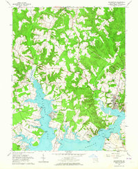
 1963 Broomes Island1964 Print · USGSCoastal Calvert County in the early sixties remains a landscape of quiet river landings and rural parishes along the Patuxent. Researchers can trace historic shorelines and family sites from Sotterley to Broomes Island, including landmarks like Island Creek Sch and Parker Wharf.3 unique versions available
 - 1964 Map of Richmond
 1964 Richmond1964 Print · USGSCoastal and central Virginia are mapped during the mid-twentieth century, showing the critical intersection of rail, river, and military life. Genealogists can trace family roots through rural county seats like Amelia or find vanished coastal neighborhoods near Phoebus and Hilton Village.
 - 1964 Map of Beltsville, 1966 Print
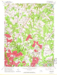 1964 Beltsville1966 Print · USGSMaryland's suburban boundary is frozen in time during the mid-sixties as research farms and military laboratories meet new residential streets. Researchers can trace family roots through Union Cem and Carver Memorial Cemetery or locate landmarks like the Ammendale Normal Institute.5 unique versions available
 - 1964 Map of Ocean City, 1966 Print
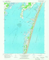
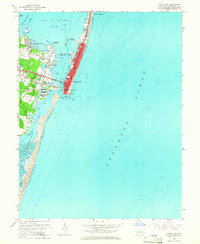 1964 Ocean City1966 Print · USGSOcean City and the surrounding barrier islands are captured in the mid-1960s as the coastal resort town expanded northward along the Atlantic. Local researchers can trace early residential developments like Bay Shore Acres or locate landmarks such as the Coast Guard Sta and Ocean City Sch.3 unique versions available
 - 1964 Map of Boxiron, 1966 Print
 1964 Boxiron1966 Print · USGSThe Worcester County coast during the mid-sixties reveals a landscape of isolated landings and intricate tidal waterways. Genealogists and historians can trace family-named sites like Scarboro Landing, the settlement of Boxiron, and landmarks such as Tizzard Island.3 unique versions available
 - 1964 Map of Whittington Point, 1966 Print
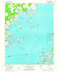
 1964 Whittington Point1966 Print · USGSAssateague Island and the Maryland-Virginia borderlands are captured here in the mid-sixties, showing the wild coastal marshes before modern changes. Local historians can trace the intricate geography of the Chincoteague National Wildlife Refuge and find landmarks like Scotts Landing and Pope Island.4 unique versions available
 - 1964 Map of Tingles Island, 1966 Print
 1964 Tingles Island1966 Print · USGSAssateague Island and the Worcester County coast are documented here in the mid-sixties, just as public recreation was being formalized. Researchers can trace the early layout of Assateague State Park or locate landmarks like Tingles Island and the Golf and Yacht Club.4 unique versions available
 - 1965 Map of Salisbury
 1965 Salisbury1965 Print · USGSThe Delmarva Peninsula in the mid-1960s is depicted here as a landscape of coastal defenses and maritime hubs. Genealogists and local historians can trace the foundations of bayside towns like Crisfield and the tactical positioning of the Fort Miles Military Reservation and Cape May Naval Air Station.
 - 1965 Map of Alexandria, 1966 Print
 1965 Alexandria1966 Print · USGSNorthern Virginia and the District of Columbia are shown in detail during the mid-sixties suburban boom. Genealogists and local historians can trace family locations near the Alexandria National Cemetery, the Arlington National Cemetery, and Mount Comfort Cemetery.6 unique versions available
 - 1965 Map of Anacostia, 1966 Print
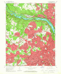
 1965 Anacostia1966 Print · USGSSoutheast Washington and Prince George's County are seen here in the mid-sixties as post-war suburban growth meets major federal installations. Trace the development of Hillcrest Heights and Forest Heights alongside institutions like Andrews Air Force Base and the Rosecroft Raceway.6 unique versions available
 - 1965 Map of Laurel, 1966 Print
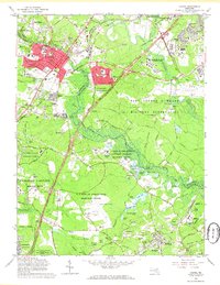 1965 Laurel1966 Print · USGSMaryland during the mid-sixties transition shows a landscape of federal expansion and established local identity. Trace the development of Laurel and Bowie alongside major institutions like the National Security Agency and Bowie State College.4 unique versions available
 - 1965 Map of Upper Marlboro, 1966 Print
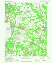 1965 Upper Marlboro1966 Print · USGSMid-century Prince George's County is caught between its rural roots and military expansion just east of Washington. Genealogists and historians can trace family locations near St Barnabas Ch, identify the early layout of Andrews Air Force Base, or locate the Croom Station rail stop.5 unique versions available
 - 1965 Map of Falls Church, 1966 Print
 1965 Falls Church1966 Print · USGSFairfax County and Montgomery County are shown here during a period of massive suburban growth in the mid-sixties. Genealogists and local historians can trace the development of McLean and Falls Church while locating landmarks like the Clara Barton House and the Washington and Old Dominion rail line.5 unique versions available
 - 1965 Map of Kensington, 1966 Print
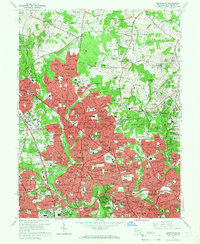 1965 Kensington1966 Print · USGSMaryland's Montgomery County suburbs are seen during their mid-century expansion, from the new Beltway to the growing streets of Kensington. Researchers can trace the development of major landmarks like the Naval Medical Center and the Wheaton Plaza Shopping Center.4 unique versions available
Showing maps 1-25 of 74
Top cities of Maryland
- Baltimore historical maps
- Columbia historical maps
- Germantown historical maps
- Waldorf historical maps
- Glen Burnie historical maps
- Frederick historical maps
See more
Top counties of Maryland
- Montgomery County historical maps
- Prince George's County historical maps
- Baltimore historical maps
- Anne Arundel County historical maps
- Howard County historical maps
- Harford County historical maps
See more
Frequently asked questions
- What are the different types of historical maps available for Maryland?
- What is the oldest map of Maryland?
- Where can I purchase historical maps of Maryland for my home or office?
- Where can I download high-res historical maps of Maryland?
- Are there historical topographic maps available for Maryland?
- Is there historical aerial imagery available for Maryland?
- Where are historical maps of Maryland sourced from?