1930s Maps of Maryland
Explore 13 historic maps of Maryland from the 1930s. These maps offer a rare glimpse into what life looked like during the 1930s — showing old roads, neighborhoods, homes, and landmarks that have changed or disappeared over time.
Whether you're researching your family's past, planning a metal detecting trip, or studying how Maryland's landscape evolved across the 1930s, these high-resolution maps are a powerful tool for exploring the history of this region.
- Focus on a specific era: All maps on this page are from the 1930s, giving you a focused view of this time period.
- See what’s changed: Compare century-old streets, trails, and buildings to today's modern landscape using overlays and satellite layers.
- Research with precision: Use these maps for genealogy, historical research, land use analysis, or educational projects.
- View, download, or print: Maps are fully viewable online in high resolution, and can be downloaded or printed for your own records.
Start exploring Maryland's history through authentic maps from the 1930s. This is your window into the past.
Maryland maps
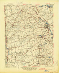
(13)- 1930 Map of Wakefield
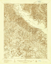
 1930 Wakefield1930 Print · USGSWestmoreland County and the Northern Neck appear here in the early thirties, defined by a historic riverfront landscape and rural hamlets. Researchers can locate the Birthplace of Washington and Monroe Birthplace alongside old river ports like Leedstown and Steve Landing.
 - 1930 Map of Wyoming, 1945 Print
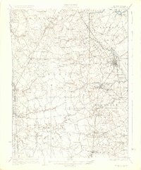
 1930 Wyoming1945 Print · USGSCentral Delaware in the mid-1920s reveals a structured landscape of rural school districts and railroad-connected towns surrounding the capital. Genealogists and historians can trace family locations near landmarks like Voshell Mill, the County Poor Farm, or many rural schoolhouses like Lockwood Sch.
 - 1931 Map of Wyoming
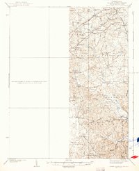
 1931 Wyoming1931 Print · USGSKent County and the Maryland borderlands are seen here between the world wars, a landscape of rail-connected towns and rural districts. Genealogists can trace family lines through numerous sites like Dinaus Corner, the County Poor Farm, and Bethel church.2 unique versions available
 - 1931 Map of Stafford
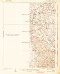
 1931 Stafford1931 Print · USGSStafford County and the city of Fredericksburg are shown here in the early 1930s, documenting a landscape still deeply shaped by nineteenth-century transit and conflict. Genealogists and historians can locate family landmarks like Mountain View PO, Enon Sch, and the grounds of the Battle of Fredericksburg 1862.
 - 1932 Map of Wakefield
 1932 Wakefield1932 Print · USGSWestmoreland County at the start of the 1930s shows a landscape defined by the great bends of the Potomac and Rappahannock Rivers. Researchers can trace ancestral locations near the George Washington Birthplace or find local landmarks like Potomac Mills and Monroe Hall.2 unique versions available
 - 1934 Map of Upper Marlboro (east half)
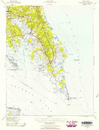
 1934 Upper Marlboro (east half)1934 Print · USGSPrince George's County is captured here in the mid-1930s as a rural landscape of crossroads communities and evolving rail lines. Genealogists and historians can trace family roots through landmarks like St Luke Ch, Glenarden Sch, and the route of the Chesapeake Beach RR.2 unique versions available
 - 1936 Map of Leonardtown
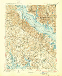
 1936 Leonardtown1936 Print · USGSSt. Mary's County wharves and rural parishes are captured in detail during the mid-1930s. Genealogists can trace family footprints at Old All Faith Ch, identify old school sites like Maryland Springs Sch, or locate historic landings such as Williams Wharf.
 - 1937 Map of Upper Marlboro
 1937 Upper Marlboro1937 Print · USGSMid-century Prince George’s County is captured here just as modern highways began to intersect its rural rail and school districts. Researchers can find old landmarks like St Barnabas Ch, the Collington Sch, and the busy Pennsylvania railroad line.
 - 1937 Map of Point Lookout, 1958 Print
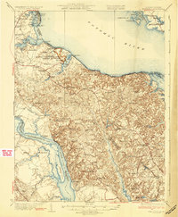
 1937 Point Lookout1958 Print · USGSThe tip of St. Mary's County appears here in the late thirties, where the Potomac meets the Chesapeake. Genealogists can trace family footprints through historic landings like Broomes Wharf and settlements such as St Inigoes and Drayden.2 unique versions available
 - 1938 Map of Prince Frederick
 1938 Prince Frederick1938 Print · USGSCalvert County at the height of the 1930s reveals a Maryland landscape defined by tobacco farming and bay-front resorts. Researchers can locate vanished rural landmarks like the Cedar Hill Sch, explore the wharves at Deep Landing, or trace the early layout of Chesapeake Beach.3 unique versions available
 - 1938 Map of Upper Marlboro
 1938 Upper Marlboro1938 Print · USGSPrince George's County at the dawn of the modern era is captured here, showing the rural landscape before the post-war expansion. Researchers can trace family sites near Holy Trinity Ch, follow the Pennsylvania RR line, and locate centers like Rosaryville and Glenn Dale.3 unique versions available
 - 1938 Map of Green Run, 1960 Print
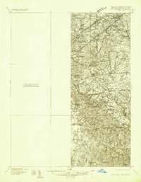
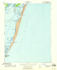 1938 Green Run1960 Print · USGSAssateague Island and the Delmarva coast appear here in the late 1930s, showing a landscape of maritime outposts and undeveloped barrier beaches. Researchers can trace the early locations of North Beach and Green Run Inlet Coast Guard Stations.
 - 1939 Map of Leonardtown
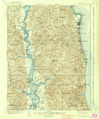
 1939 Leonardtown1939 Print · USGSSouthern Maryland's river-oriented landscape is captured here in the late 1930s, centered on the community of Leonardtown. Genealogists can trace family roots through numerous country schools and landmarks like Bannaker Sch, St Andrews Ch, and the many landings along the Patuxent River.3 unique versions available
End of results
Showing maps 1-13 of 13
Top cities of Maryland
- Baltimore historical maps
- Columbia historical maps
- Germantown historical maps
- Waldorf historical maps
- Glen Burnie historical maps
- Frederick historical maps
See more
Top counties of Maryland
- Montgomery County historical maps
- Prince George's County historical maps
- Baltimore historical maps
- Anne Arundel County historical maps
- Howard County historical maps
- Harford County historical maps
See more
Frequently asked questions
- What are the different types of historical maps available for Maryland?
- What is the oldest map of Maryland?
- Where can I purchase historical maps of Maryland for my home or office?
- Where can I download high-res historical maps of Maryland?
- Are there historical topographic maps available for Maryland?
- Is there historical aerial imagery available for Maryland?
- Where are historical maps of Maryland sourced from?