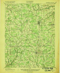
1910s Maps of Maryland
Explore 26 historic maps of Maryland from the 1910s. These maps offer a rare glimpse into what life looked like during the 1910s — showing old roads, neighborhoods, homes, and landmarks that have changed or disappeared over time.
Whether you're researching your family's past, planning a metal detecting trip, or studying how Maryland's landscape evolved across the 1910s, these high-resolution maps are a powerful tool for exploring the history of this region.
- Focus on a specific era: All maps on this page are from the 1910s, giving you a focused view of this time period.
- See what’s changed: Compare century-old streets, trails, and buildings to today's modern landscape using overlays and satellite layers.
- Research with precision: Use these maps for genealogy, historical research, land use analysis, or educational projects.
- View, download, or print: Maps are fully viewable online in high resolution, and can be downloaded or printed for your own records.
Start exploring Maryland's history through authentic maps from the 1910s. This is your window into the past.
Maryland maps
(26)- 1910 Map of Prince Frederick
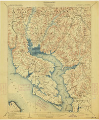
 1910 Prince Frederick1910 Print · USGSCoastal Calvert County comes alive in the early twentieth century, showing a landscape defined by the Patuxent River and the bay. Genealogists can trace old wharves and family settlements from Lower Marlboro to the Chesapeake Beach RR line.3 unique versions available
 - 1910 Map of Antietam
 1910 Antietam1910 Print · USGSMaryland's borderlands and the Potomac River valley are captured here in the early twentieth century. Genealogists can locate family landmarks like Garretts Mill, trace the Chesapeake and Ohio Canal, or find historic sites including Dunkard Church.6 unique versions available
 - 1910 Map of Paw Paw, 1959 Print
 1910 Paw Paw1959 Print · USGSMaryland and West Virginia meet along the serpentine Potomac River in the early twentieth century as railroads and canals compete for the valley. Trace the industrial landscape from the Ohio and Chesapeake Canal to the river towns of Paw Paw and Little Orleans.
 - 1911 Map of Taneytown
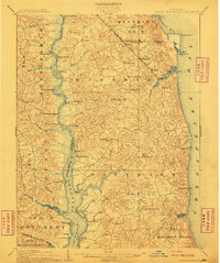
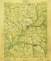
 1911 Taneytown1911 Print · USGSCarroll County and the Maryland-Pennsylvania borderlands are captured here just after the turn of the century, showing a network of rail-linked towns and water-powered mills. Trace local history through Taneytown, Union Mills, and Pipe Creek Church, or find early school sites like Centennial Hall School.6 unique versions available
 - 1911 Map of Emmitsburg
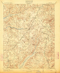
 1911 Emmitsburg1911 Print · USGSMaryland's northern borderlands and the Catoctin mountains thrived in the early twentieth century as a hub for institutions, railroads, and milling. Genealogists and historians can locate family homes and old crossroads near St Josephs Academy, Sabillasville, and the Western Maryland RR.6 unique versions available
 - 1911 Map of Wicomico, 1961 Print
 1911 Wicomico1961 Print · USGSSouthern Maryland's river-dependent landscape is documented here during the early twentieth century, showing the tidewater border of Charles and St Marys counties. Genealogists can trace family-named points and wharves like Lancaster Wharf, the Laidlow Ferry, and the rail terminus at Popes Creek.
 - 1911 Map of Brandywine, 1962 Print
 1911 Brandywine1962 Print · USGSSouthern Maryland at the turn of the century shows a landscape of rail-connected farming towns and expansive wetlands. Researchers can trace ancestral locations near LA PLATA, the old Reform School, or country parishes like St Peters Church and Piney Church.
 - 1912 Map of Point Lookout
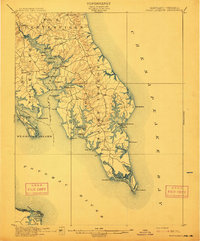 1912 Point Lookout1912 Print · USGSSouthern St. Mary's County appears here just after the turn of the century, showing a waterfront economy dependent on the river and bay. Genealogists and historians can trace family landings at Broomes Wharf and Miller Wharf or locate old settlements like St Inigoes and Great Mills.2 unique versions available
 - 1912 Map of Hagerstown
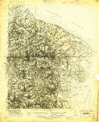
 1912 Hagerstown1912 Print · USGSMaryland's Cumberland Valley flourished as a rail and milling corridor during the early twentieth century. Genealogists can trace family names across dozens of rural landmarks like Strites Mill, Hallowell Church, and the Paradise School.9 unique versions available
 - 1912 Map of Williamsport
 1912 Williamsport1912 Print · USGSUpper Maryland and the West Virginia panhandle were bustling centers of river and rail transit before the First World War. Researchers can trace the path of the Chesapeake and Ohio Canal and locate family landmarks like Cushwa Mill or the St James School.3 unique versions available
 - 1913 Map of Brandywine
 1913 Brandywine1913 Print · USGSSouthern Maryland at the turn of the century shows a landscape transitioning through early rail and rural growth. Genealogists can trace family roots through landmarks like St Peters Church, Winkler Shop School, and old stops such as Malcolm Woodville Station.3 unique versions available
 - 1913 Map of Indian Head
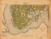
 1913 Indian Head1913 Print · USGSThe Potomac River tidewater south of the capital was a region of defensive forts and busy river landings before the First World War. Researchers can trace the early layout of the Naval Proving Grounds and locate family landmarks like Mattinglys Wharf or the Granny Thompson School.2 unique versions available
 - 1913 Map of Nanjemoy
 1913 Nanjemoy1913 Print · USGSThe Nanjemoy peninsula in the early nineteen-hundreds was a world of tidal creeks and tobacco landings. Researchers can trace the rural fabric of Charles County through family-named landmarks like Mudds Marsh and community hubs such as Durham Church and Green Leek School.3 unique versions available
 - 1914 Map of Martinsburg
 1914 Martinsburg1914 Print · USGSThe eastern panhandle of West Virginia comes alive in this survey, showing a landscape defined by the Potomac River and burgeoning rail hubs. Genealogists can trace family footprints through dozens of schools and churches, from Shepherdstown to the Snyder Hill Riverside School and John Browns Cave.3 unique versions available
 - 1914 Map of Wicomico
 1914 Wicomico1914 Print · USGSSouthern Maryland's riverfront life is captured here during the early twentieth century, showing a landscape of tidal creeks and busy steamboat landings. Genealogists can trace family footprints near Charlotte Hall, find old crossings like Ludlow Ferry, or locate historic maritime hubs like Bushwood Wharf.4 unique versions available
 - 1915 Map of Fairfax
 1915 Fairfax1915 Print · USGSNorthern Virginia in the early twentieth century appears as a collection of quiet rail towns and farmsteads. Trace the old routes of the Southern RR and find family-named landmarks like Sideburn, Balls Ford, and Bear School.4 unique versions available
 - 1915 Map of Seaford
 1915 Seaford1915 Print · USGSCoastal Sussex County and the Maryland borderlands are seen here at a time when river traffic and rail lines were the lifeblood of the region. Researchers can trace the Steamboat Route up to Seaford or locate ancestral sites like Cannons Ferry and Cokesbury School.4 unique versions available
 - 1916 Map of Martinsburg
 1916 Martinsburg1916 Print · USGSThe Eastern Panhandle of West Virginia comes to life in the years before the Great War, showing a bustling hub of rail activity and river commerce. Genealogists and historians can trace family roots through schoolhouses like Sutton School and old settlements such as Middleway and Summit Point.4 unique versions available
 - 1916 Map of Davis
 1916 Davis1916 Print · USGSHigh in the Allegheny plateau during the mid-teens, this area centers on the bustling timber and rail hubs of Thomas and Davis. Researchers can trace the path of the Lumber RR and locate rural neighborhood centers like Maple Grove School and Cortland School.2 unique versions available
 - 1917 Map of Elkton
 1917 Elkton1917 Print · USGSNorthern Cecil County and the Delaware borderlands appear here in the era of rail and canal dominance. Genealogists can trace family names across Back Creek Neck or locate early settlements like Lewisville and Mechanic Valley.
 - 1917 Map of Heathsville
 1917 Heathsville1917 Print · USGSNorthumberland County's peninsulas and maritime crossroads are intricately detailed here during the late 1910s. Local researchers can trace family roots through historic landmarks like Macedonia Church, Coan Hall School, and the busy waters of the Steamboat Route at Reedville.4 unique versions available
 - 1917 Map of Ewell
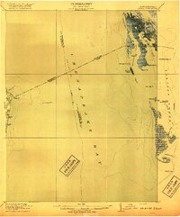 1917 Ewell1917 Print · USGSIsolated island life in the Chesapeake comes into focus during the early twentieth century. Researchers can trace the original footprints of Ewell, Rhodes Point, and Tangier, alongside maritime landmarks like the Smith Point LH and old Steamboat Routes.2 unique versions available
 - 1918 Map of Davis
 1918 Davis1918 Print · USGSTucker County's high mountain plateaus and timber industry are at their peak during the First World War. Genealogists and historians can trace the early development of Davis and Thomas alongside rural landmarks like Maple Grove School and the Fairfax Stone.
 - 1918 Map of Harrington
 1918 Harrington1918 Print · USGSThe Kent and Sussex County borderlands at the end of the Great War reveal a landscape of busy rail corridors and small schoolhouses. Researchers can trace the legacy of rural education at Union Chapel School or locate family roots near Harrington and Hickman.4 unique versions available
 - 1919 Map of Elk Garden
 1919 Elk Garden1919 Print · USGSThe Potomac River corridor in the years following the Great War reveals a landscape defined by rail and ridge. Genealogists can trace family names at Rehoboth Church or locate vanished school sites like Terra Firma School and Empire School.2 unique versions available
Showing maps 1-25 of 26
Top cities of Maryland
- Baltimore historical maps
- Columbia historical maps
- Germantown historical maps
- Waldorf historical maps
- Glen Burnie historical maps
- Frederick historical maps
See more
Top counties of Maryland
- Montgomery County historical maps
- Prince George's County historical maps
- Baltimore historical maps
- Anne Arundel County historical maps
- Howard County historical maps
- Harford County historical maps
See more
Frequently asked questions
- What are the different types of historical maps available for Maryland?
- What is the oldest map of Maryland?
- Where can I purchase historical maps of Maryland for my home or office?
- Where can I download high-res historical maps of Maryland?
- Are there historical topographic maps available for Maryland?
- Is there historical aerial imagery available for Maryland?
- Where are historical maps of Maryland sourced from?