2000-2009 Maps of Michigan
Explore 1 historic maps of Michigan from 2000-2009. These maps offer a rare glimpse into what life looked like during the 2000s — showing old roads, neighborhoods, homes, and landmarks that have changed or disappeared over time.
Whether you're researching your family's past, planning a metal detecting trip, or studying how Michigan's landscape evolved across the 2000s, these high-resolution maps are a powerful tool for exploring the history of this region.
- Focus on a specific era: All maps on this page are from the 2000s, giving you a focused view of this time period.
- See what’s changed: Compare century-old streets, trails, and buildings to today's modern landscape using overlays and satellite layers.
- Research with precision: Use these maps for genealogy, historical research, land use analysis, or educational projects.
- View, download, or print: Maps are fully viewable online in high resolution, and can be downloaded or printed for your own records.
Start exploring Michigan's history through authentic maps from the 2000s. This is your window into the past.
Michigan maps
(1)- 2001 Map of Underwood Hill, 2004 Print
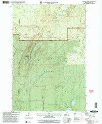 2001 Underwood Hill2004 Print · USGSThe wilderness of the Upper Peninsula is preserved here at the start of the 2000s, where the high ridges of the Porcupine Mountains meet the Ottawa National Forest. Researchers can trace the paths of the North Country National Scenic Trail, locate the settlement of Underwood, and find landmarks like Greenstone Falls.
End of results
Showing maps 1-1 of 1
Top cities of Michigan
- Detroit historical maps
- Grand Rapids historical maps
- Sterling Heights historical maps
- Warren historical maps
- Ann Arbor historical maps
- Lansing historical maps
See more
Top counties of Michigan
- Wayne County historical maps
- Oakland County historical maps
- Macomb County historical maps
- Kent County historical maps
- Genesee County historical maps
- Washtenaw County historical maps
See more
Frequently asked questions
- What are the different types of historical maps available for Michigan?
- What is the oldest map of Michigan?
- Where can I purchase historical maps of Michigan for my home or office?
- Where can I download high-res historical maps of Michigan?
- Are there historical topographic maps available for Michigan?
- Is there historical aerial imagery available for Michigan?
- Where are historical maps of Michigan sourced from?