Old Maps of Michigan for Hiking & Exploration
Hike through history with 3,659 historic maps of Michigan. Explore old trails, ghost towns, and forgotten backroads — perfect for outdoor adventurers and local explorers.
- Rediscover forgotten places: Map out old mining camps, roads, and footpaths that no longer exist on modern maps.
- Layer with modern tools: Combine with LiDAR or satellite views to plan hikes through historical terrain.
- Made for exploration: Popular among hikers, overlanders, and local history lovers.
Use these maps to find adventure and explore the hidden past of Michigan.
Michigan maps
(3,659)- 1895 Map of Ned Lake
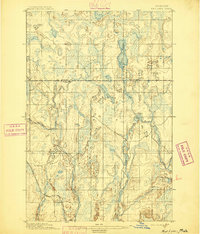 1895 Ned Lake1895 Print · USGSIron County and Baraga County are captured here during the late nineteenth-century timber and mining era. You can trace the path of the Chicago Milwaukee and St Paul RR as it bypasses the waters of Ned Lake and the Hemlock River.4 unique versions available
 - 1895 Map of Passage Island
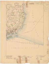
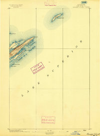 1895 Passage Island1895 Print · USGSThe northeast tip of Michigan's wilderness archipelago appears in the late nineteenth century as maritime navigation became increasingly precise. Trace the rugged coastline from Blake Pt. down to the inlets of Duncan Bay and the safety of Passage Island.3 unique versions available
 - 1895 Map of Perch Lake
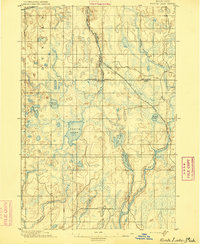 1895 Perch Lake1895 Print · USGSThe Upper Peninsula wilderness comes into focus in the mid-1890s as railroads began to pierce the deep woods of Iron and Baraga counties. Genealogists and historians can trace early rail routes like the D. S. S. and A. R. R. and remote waters such as Perch Lake and the Net River.3 unique versions available
 - 1898 Map of Iron River, 1899 Print
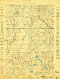
 1898 Iron River1899 Print · USGSUpper Peninsula mining and timber frontiers emerge in the 1890s as railroads begin connecting remote outposts. Researchers can trace early rail lines through Iron River and Stambaugh or locate former stations and camps at Hazle, Atkinson, and Saunders.2 unique versions available
 - 1899 Map of Sagola
 1899 Sagola1899 Print · USGSIron and Dickinson counties were defined by the expansion of the rail-and-river economy in the late nineteenth century. Genealogists and historians can trace the early layouts of Channing, Sagola, and Mansfield alongside the winding Michigamme River.3 unique versions available
 - 1899 Map of Witbeck
 1899 Witbeck1899 Print · USGSThe Upper Peninsula’s rugged timber and rail corridor comes to life in this survey conducted during the 1890s. Researchers can trace the dual rail lines serving Witbeck or locate early wilderness landmarks like Fence Lake, Witch Lake, and the winding Michigamme River.3 unique versions available
 - 1899 Map of Crystal Falls
 1899 Crystal Falls1899 Print · USGSIron County mining and timber operations are at their peak at the close of the century. Genealogists and industrial historians can trace early rail spurs to the Mastodon Mine, Shafer Mine, and the developing town of Crystal Falls.2 unique versions available
 - 1900 Map of Maumee Bay, 1921 Print
 1900 Maumee Bay1921 Print · USGSNorthwest Ohio and the Lake Erie shoreline are shown here just as the regions rail and energy sectors were maturing. Genealogists and historians can locate vanished post offices at Shepardsville Bono P. O. and trace early industrial sites like the Oil Wells and Coke Ovens near Curtice.2 unique versions available
 - 1900 Map of Toledo, 1932 Print
 1900 Toledo1932 Print · USGSToledo and the lower Maumee River valley are shown at the height of the railroad era, as the city expanded into an industrial powerhouse. Researchers can trace early infrastructure like the Michigan Division Canal and locate historic sites like the Toledo Insane Asylum or the Oil Wells near Lime City.
 - 1902 Map of South Lyon, 1954 Print
 1902 South Lyon1954 Print · USGSSoutheast Michigan at the turn of the century reveals a landscape of thriving rail junctions and rural townships across Oakland and Washtenaw counties. Trace the early footprints of Ann Arbor and South Lyon alongside historic whistle-stops like Emery and Geddes.
 - 1902 Map of Ypsilanti, 1958 Print
 1902 Ypsilanti1958 Print · USGSSoutheast Michigan at the turn of the century shows a landscape defined by thriving rail towns and winding river valleys. Genealogists and historians can trace the early footprints of Ypsilanti or find smaller locales like Rawsonville and Azalia along the Huron River and Michigan Central RR.
 - 1902 Map of Dexter, 1962 Print
 1902 Dexter1962 Print · USGSWashtenaw and Livingston counties are captured here at the start of the 1900s, as a dense network of steam and electric railroads connected riverside mill towns. Researchers can trace the vanished industrial sites at Hudson Mills, the rail junctions at Lakeland, and the early layout of Pinckney.
 - 1904 Map of Ann Arbor
 1904 Ann Arbor1904 Print · USGSEarly twentieth-century Washtenaw County comes to life through its dense network of interurban electric lines and steam railroads. Researchers can trace the layout of Ann Arbor, locate the Duck Lake School, or find vanished stops along the Michigan Central R. R. and Ann Arbor R. R..2 unique versions available
 - 1905 Map of Wayne
 1905 Wayne1905 Print · USGSWestern Wayne and southern Oakland counties are seen here at a pivotal moment when electric interurban railways first linked rural townships. Genealogists can trace family footprints in Northville, Plymouth, and Farmington, or locate vanished landmarks like Perrinville and the Wayne County Home.4 unique versions available
 - 1905 Map of Detroit
 1905 Detroit1905 Print · USGSDetroit and its surrounding townships are shown at a pivotal moment of expansion during the early 1900s. Genealogists and historians can trace the development of early suburbs like Highland Park and Royal Oak along major transit arteries like Grand River Ave. and the numerous electric railways.2 unique versions available
 - 1905 Map of Grosse Pointe
 1905 Grosse Pointe1905 Print · USGSCoastal Wayne County at the turn of the century shows an era of transit-driven growth along Lake St Clair. Researchers can trace the early layout of Grosse Pointe Shores, the grounds of Belle Isle Park, and the route of the Grand Trunk R R.4 unique versions available
 - 1906 Map of Ypsilanti
 1906 Ypsilanti1906 Print · USGSSoutheast Michigan at the dawn of the century reveals a landscape defined by its bustling river towns and burgeoning rail networks. Trace the early development of Ypsilanti and Milan or locate vanished stops along the Michigan Central RR and the Wabash RR.3 unique versions available
 - 1906 Map of Wyandotte
 1906 Wyandotte1906 Print · USGSThe Detroit River shoreline and its industrial borderlands are captured here at the height of the electric railway era. Genealogists and historians can trace the early footprints of Wyandotte, the development of Grosse Isle, and the complex rail networks of the M C R R.2 unique versions available
 - 1906 Map of Dexter
 1906 Dexter1906 Print · USGSSoutheast Michigan at the turn of the century shows a landscape defined by riverside mills and a dense network of glacial lakes. Genealogists and historians can trace the early rail corridors through Dexter, the mill sites at Delhi Mills, and the small villages of Pinckney and Pettysville.4 unique versions available
 - 1906 Map of Saline
 1906 Saline1906 Print · USGSSoutheastern Michigan at the start of the century was a landscape of thriving rail hubs and productive farm country. Trace the early tracks of the Lake Shore and Michigan Southern R R through the streets of Saline, Tecumseh, and the village of Clinton.4 unique versions available
 - 1906 Map of South Lyon
 1906 South Lyon1906 Print · USGSSoutheast Michigan at the turn of the century shows a landscape defined by an intricate web of steam and electric railways. Researchers can trace the early layouts of Ann Arbor and South Lyon, or locate smaller depots like Whitmore Lake Station and Rushton.5 unique versions available
 - 1906 Map of Romulus
 1906 Romulus1906 Print · USGSSoutheast Michigan at the turn of the century shows a landscape defined by the winding Huron River and a dense network of competing steam and electric railways. Genealogists can trace early homesteads and rail stops in settlements like New Boston, Waltz, and the early crossroads at Carleton.2 unique versions available
 - 1907 Map of Marquette
 1907 Marquette1907 Print · USGSMarquette and its Lake Superior shoreline appear here during a period of heavy industrial growth in the early twentieth century. Researchers can trace the complex rail networks of the Marquette and Southeastern and locate landmarks like the State Prison and Powder Works.3 unique versions available
 - 1907 Map of Pontiac
 1907 Pontiac1907 Print · USGSOakland County is captured here at a pivotal moment when early electric railways and the Grand Trunk line first connected these lake communities. Trace historic institutional landmarks like the Asylum and Military Academy alongside the Bigelow Mill.5 unique versions available
 - 1907 Map of Howell, 1959 Print
 1907 Howell1959 Print · USGSLivingston County is mapped here in the early twentieth century as a busy rail and agricultural center. Researchers can trace the legacy of rural education and industry through dozens of local sites like Jubb School, Parker Church, and the State Sanitarium.2 unique versions available
Showing maps 1-25 of 3,659
Top cities of Michigan
- Detroit historical maps
- Grand Rapids historical maps
- Sterling Heights historical maps
- Warren historical maps
- Ann Arbor historical maps
- Lansing historical maps
See more
Top counties of Michigan
- Wayne County historical maps
- Oakland County historical maps
- Macomb County historical maps
- Kent County historical maps
- Genesee County historical maps
- Washtenaw County historical maps
See more
Frequently asked questions
- What are the different types of historical maps available for Michigan?
- What is the oldest map of Michigan?
- Where can I purchase historical maps of Michigan for my home or office?
- Where can I download high-res historical maps of Michigan?
- Are there historical topographic maps available for Michigan?
- Is there historical aerial imagery available for Michigan?
- Where are historical maps of Michigan sourced from?