1920s Maps of Michigan
Explore 34 historic maps of Michigan from the 1920s. These maps offer a rare glimpse into what life looked like during the 1920s — showing old roads, neighborhoods, homes, and landmarks that have changed or disappeared over time.
Whether you're researching your family's past, planning a metal detecting trip, or studying how Michigan's landscape evolved across the 1920s, these high-resolution maps are a powerful tool for exploring the history of this region.
- Focus on a specific era: All maps on this page are from the 1920s, giving you a focused view of this time period.
- See what’s changed: Compare century-old streets, trails, and buildings to today's modern landscape using overlays and satellite layers.
- Research with precision: Use these maps for genealogy, historical research, land use analysis, or educational projects.
- View, download, or print: Maps are fully viewable online in high resolution, and can be downloaded or printed for your own records.
Start exploring Michigan's history through authentic maps from the 1920s. This is your window into the past.
Michigan maps
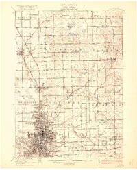
(34)- 1920 Map of Flint
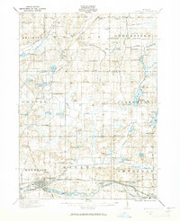
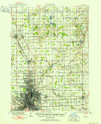 1920 Flint1920 Print · USGSFlint and the surrounding Genesee County townships appear in this post-war survey during a period of intense industrial and civic growth. Genealogists and historians can trace numerous rural school sites like Beecher School and major rail lines including the Pere Marquette.2 unique versions available
 - 1920 Map of Holly, 1964 Print
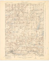
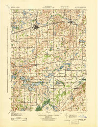
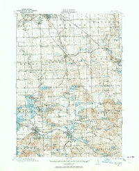 1920 Holly1964 Print · USGSOakland and Genesee counties at the height of the rail era show a landscape of interconnected small towns and lakeside settlements. Trace the legacy of early transit via the United Electric Railway or locate family landmarks like Groveland Mills and Hadley Cemetery.
 - 1921 Map of Burt
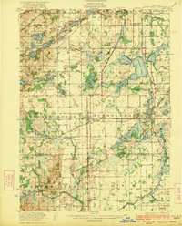
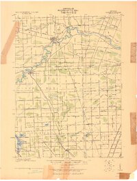
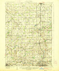
 1921 Burt1921 Print · USGSSaginaw and Genesee Counties are captured here at the end of the Great War, showing a landscape of tight-knit farming communities and early electric transit. Researchers can trace family roots through dozens of named sites like St Michaels Church, Marr School, and the Michigan Electric Railway.2 unique versions available
 - 1921 Map of Rives Junction
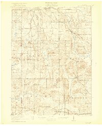
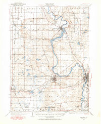
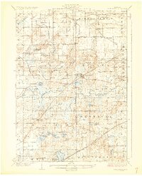
 1921 Rives Junction1921 Print · USGSJackson and its northern rural townships are captured in the early twenties, a time of small school districts and steam-powered rail travel. Genealogists can locate family landmarks such as Bunker Hill Chapel, the County Infirmary, and East Rives Cemetery.3 unique versions available
 - 1921 Map of Springport
 1921 Springport1921 Print · USGSCentral Michigan's agricultural heartland at the end of the Great War reveals a landscape of dispersed farmsteads and numerous small school districts. Genealogists can trace family lands near Onondaga, Kinneville, and Chapel Cemetery, or locate vanished schoolhouses like Knight School and Fisk School.2 unique versions available
 - 1921 Map of Marshall, 1965 Print
 1921 Marshall1965 Print · USGSSouthern Michigan in the early 1920s is defined by its busy rail corridors and countless rural school districts. Researchers can trace the development of Marshall and Albion or locate vanished landmarks like the County Infirmary and Town Line Church.2 unique versions available
 - 1922 Map of Schoolcraft
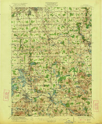
 1922 Schoolcraft1922 Print · USGSSouthern Kalamazoo and northern St. Joseph counties are captured here in the early 1920s as a thriving hub of rail transport and rural education. Genealogists can trace family footprints through dozens of local sites, from the rail junction at Schoolcraft to the lakeside Ramona Park and the Flowerfield Sta.5 unique versions available
 - 1922 Map of Holly
 1922 Holly1922 Print · USGSSoutheast of the industrial rise of Flint in the early 1920s, this region reveals a landscape of lakeside settlements and small-town village life. Genealogists can locate family-named sites like Ainsworth Corners, Gravel Lake Cemetery, and dozens of rural schoolhouses including Atherton School and Howe School.3 unique versions available
 - 1922 Map of Durand
 1922 Durand1922 Print · USGSShiawassee and Genesee counties come alive in the early 1920s as a bustling junction of rail and river. Researchers can trace the sprawling Grand Trunk lines through Durand or locate family roots near the Crapo Farm and Unity Grange.4 unique versions available
 - 1922 Map of Stockbridge
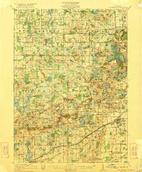 1922 Stockbridge1922 Print · USGSSoutheastern Michigan at the start of the twenties is a land of rail-connected hamlets and countless country schools. Genealogists can trace family footprints near Stockbridge and Unadilla, or locate rural landmarks like Strobel School and Sylvan Sta.3 unique versions available
 - 1922 Map of Flint
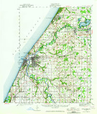
 1922 Flint1922 Print · USGSGenesee County comes to life in the early twenties, showing the industrial rise of the vehicle city alongside its rural townships. Researchers can trace family sites near Gracelawn Cemetery or locate old schoolhouses like Boutwell School and Holden School.3 unique versions available
 - 1923 Map of Marshall
 1923 Marshall1923 Print · USGSSouthern Michigan in the early twenties reveals a landscape of growing towns and busy rail corridors. Genealogists can trace rural family roots through dozens of local schoolhouses and centers like Lee Center, Partello, and Town Line Church.4 unique versions available
 - 1924 Map of Detroit
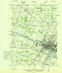
 1924 Detroit1924 Print · USGSDetroit and its industrial satellites thrive during the peak of the automotive era. Genealogists and historians can trace the early factory footprints of Dodge Bros. or locate old neighborhood landmarks like Navarre P. O. and Mt. Olivet Cemetery.
 - 1926 Map of Dundee
 1926 Dundee1926 Print · USGSSoutheastern Michigan is captured here during the height of the steam-rail era, showing the intricate network of Monroe County townships. Genealogists and historians can trace family locations near Dundee, Lambertville, or the rail junctions at Ida and Strasburgh.
 - 1926 Map of Corunna, 1958 Print
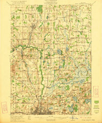
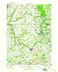
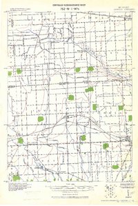
 1926 Corunna1958 Print · USGSShiawassee County in the mid-twenties shows a landscape of busy rail junctions and productive farmland. Genealogists can trace family roots through numerous rural schools like Eddy Sch and settlements including Bancroft and Shiawasseetown.2 unique versions available
 - 1927 Map of Niles
 1927 Niles1927 Print · USGSBerrien County and the Michigan-Indiana borderlands are captured here during the late 1920s, showing a landscape of river-powered towns and rural school districts. Genealogists can trace family roots through dozens of local landmarks like Ruggles Cem, Salem Ch, and Emmanuel Missionary College.
 - 1927 Map of Point Isabelle
 1927 Point Isabelle1927 Print · USGSThe southern coast of the Keweenaw Peninsula is captured here in the late 1930s, documenting the remote shoreline before major modern changes. Trace the maritime history of Mendota through landmarks like the Mendota L H and the Mendota Canal.
 - 1927 Map of De Witt
 1927 De Witt1927 Print · USGSClinton County and its neighbors are captured here in the 1920s, showing a landscape of small farming townships and river-fed settlements. Researchers can trace dozens of rural school sites like Bengal Center School and local landmarks like Oak Ridge Cemetery or the Wilsey Church.3 unique versions available
 - 1927 Map of Monroe
 1927 Monroe1927 Print · USGSMonroe and the surrounding Lake Erie shoreline are shown here during the late 1930s as a thriving industrial and rail corridor. Researchers can locate family landmarks like the Monroe Co Cem, Strasburg Sch, and the notable Monroe Co Infirmary.
 - 1927 Map of Hartford, 1943 Print
 1927 Hartford1943 Print · USGSVan Buren County agriculture and lakeside leisure meet in the late 1920s as Hartford and Lawrence thrive along the Pere Marquette rail line. Researchers can locate numerous rural schoolhouses, the historic Red Mill, and early resort development at Sister Lakes and Woodland Beach.3 unique versions available
 - 1927 Map of Bangor, 1959 Print
 1927 Bangor1959 Print · USGSVan Buren and Allegan counties show a landscape of thriving lakeside resorts and rail-fed farming towns in the late twenties. Trace family roots at Kibbie Chapel or the many local schools like Garden of Eden School and Arlington Center School.2 unique versions available
 - 1927 Map of Benton Harbor, 1964 Print
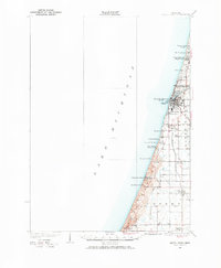
 1927 Benton Harbor1964 Print · USGSBenton Harbor and St. Joseph dominate the Lake Michigan shoreline in this late 1920s survey of Berrien County commerce and transit. Genealogists can locate dozens of rural schoolhouses like Bacon Sch and Hull Sch alongside local landmarks like the House of David.
 - 1927 Map of South Haven, 1972 Print
 1927 South Haven1972 Print · USGSThe Lake Michigan shoreline of Van Buren County flourished as a resort and agricultural destination during the late twenties. You can trace the Pere Marquette rail line through South Haven and Covert, or find old schoolhouses like Law Sch and Fish Sch.
 - 1928 Map of Armada
 1928 Armada1928 Print · USGSMacomb and St. Clair counties are shown here in the early twentieth century as agriculture and rail travel dominated the landscape. Genealogists can trace family roots through specific locales like Doyle P.O., Sullicks Corners, and the mill at Wolcots Mill Pond.
 - 1928 Map of Laingsburg
 1928 Laingsburg1928 Print · USGSCentral Michigan in the late twenties shows a landscape of busy rural school districts and multiple rail lines connecting the tri-county area. Local historians can trace family locations near Octagon Sch, Reed Church, and the tracks of the Michigan Electric Railway.5 unique versions available
Showing maps 1-25 of 34
Top cities of Michigan
- Detroit historical maps
- Grand Rapids historical maps
- Sterling Heights historical maps
- Warren historical maps
- Ann Arbor historical maps
- Lansing historical maps
See more
Top counties of Michigan
- Wayne County historical maps
- Oakland County historical maps
- Macomb County historical maps
- Kent County historical maps
- Genesee County historical maps
- Washtenaw County historical maps
See more
Frequently asked questions
- What are the different types of historical maps available for Michigan?
- What is the oldest map of Michigan?
- Where can I purchase historical maps of Michigan for my home or office?
- Where can I download high-res historical maps of Michigan?
- Are there historical topographic maps available for Michigan?
- Is there historical aerial imagery available for Michigan?
- Where are historical maps of Michigan sourced from?