1990s Maps of Michigan
Explore 114 historic maps of Michigan from the 1990s. These maps offer a rare glimpse into what life looked like during the 1990s — showing old roads, neighborhoods, homes, and landmarks that have changed or disappeared over time.
Whether you're researching your family's past, planning a metal detecting trip, or studying how Michigan's landscape evolved across the 1990s, these high-resolution maps are a powerful tool for exploring the history of this region.
- Focus on a specific era: All maps on this page are from the 1990s, giving you a focused view of this time period.
- See what’s changed: Compare century-old streets, trails, and buildings to today's modern landscape using overlays and satellite layers.
- Research with precision: Use these maps for genealogy, historical research, land use analysis, or educational projects.
- View, download, or print: Maps are fully viewable online in high resolution, and can be downloaded or printed for your own records.
Start exploring Michigan's history through authentic maps from the 1990s. This is your window into the past.
Michigan maps
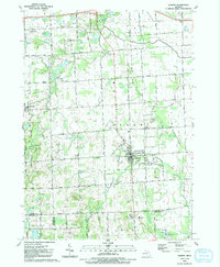
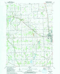
(114)- 1990 Map of Wakefield
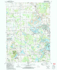
 1990 Wakefield1990 Print · USGSThe Michigan-Wisconsin borderlands are captured here in the late twentieth century, showing the transition from an industrial rail-and-timber hub to a recreation-focused landscape. Trace the Chicago & North Western RR through Marenisco or locate landmarks like Agate Falls and Wakefield.
 - 1990 Map of Flint, 1991 Print
 1990 Flint1991 Print · USGSThe Flint and Saginaw corridors are captured here in the early nineties, showing a landscape defined by heavy industry and rural expanses. Genealogists and historians can trace the rail lines of the Penn Central RR, visit Flint Memorial Park Cem, or explore the limits of Zilwaukee.
 - 1990 Map of Adrian, 1991 Print
 1990 Adrian1991 Print · USGSThe Michigan and Ohio borderlands come alive in the final decade of the twentieth century, showing the intricate network of glacial lakes and small-town junctions. Genealogists and local researchers can pinpoint family landmarks from Lakeview Cem to the rail sidings of the Conrail and Norfolk Southern lines.
 - 1990 Map of Outer Island, 1991 Print
 1990 Outer Island1991 Print · USGSThe northern Apostle Islands and the Lake Superior shoreline are captured here in the early 1990s. Researchers can trace remote maritime landmarks like the Outer Island Light and Devils Island or explore the coastal boundary of the Finland State Forest.
 - 1991 Map of Oxford
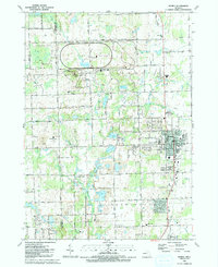
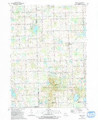
 1991 Oxford1991 Print · USGSInland Oakland County in the early nineties shows a landscape of deep glacial lakes and heavy industry. Genealogists can locate family sites at Case Cem or Seymour Lake Cem, while others can trace the Grand Trunk Western RR and numerous gravel pits.2 unique versions available
 - 1991 Map of Iron Mountain
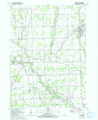
 1991 Iron Mountain1991 Print · USGSThe Michigan-Wisconsin borderlands appear here in the early nineties, centered on the industrial corridor along the Menominee River. Local researchers can trace the Soo Line through remote timber settlements or locate mining sites like the Bradley Mine and Trader Mine.
 - 1991 Map of Metamora
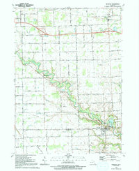
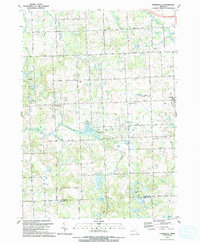
 1991 Metamora1991 Print · USGSLapeer County's lake-studded landscape is captured here in the early nineties as rural homesteads and recreation areas define the terrain. Researchers can trace family history at Farmers Creek Cem, locate the village of Metamora, and find the D Bar A Scout Ranch.
 - 1991 Map of Rattle Run
 1991 Rattle Run1991 Print · USGSThe rural stretches of St. Clair County are captured here in the early nineties as traditional farming met a growing energy infrastructure. Researchers can trace family roots at Bowman Cem, locate the site of Belle River Mills, or map the extent of the Adair Oil Field.
 - 1991 Map of Adair
 1991 Adair1991 Print · USGSAgricultural life meets the energy industry in St. Clair County during the early nineties, where river valleys are dotted with old family-named drains and oil fields. Genealogists can locate legacy sites like St Michaels Cem, St Peter Sch, and the quiet crossroads of Snyderville.
 - 1991 Map of St. Clair
 1991 St. Clair1991 Print · USGSThe international border along the St. Clair River was a hub of shared waterway activity in the early 1990s. Researchers can trace the layout of St Clair and Hawthorne, alongside local landmarks like St Marys Cem and Rose Hill Cem.
 - 1991 Map of Ortonville
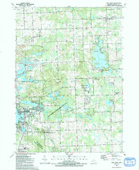
 1991 Ortonville1991 Print · USGSOakland County's lake-rich landscape in the early nineties shows a balance of small-town life and vast public recreation areas. Researchers can trace family history through sites like Ortonville Cem, Mt Bethel Ch, and the Old Railroad Grade.
 - 1991 Map of Big Rapids
 1991 Big Rapids1991 Print · USGSWest Michigan’s river valleys and timberlands are charted here during the early nineties, centered on the Big Rapids corridor. Researchers can trace the path of the C & O RR through settlements like Reed City, Baldwin, and White Cloud.
 - 1991 Map of Smiths Creek
 1991 Smiths Creek1991 Print · USGSSt. Clair County's mix of rural townships and expanding aviation infrastructure is captured here in the early nineties. Researchers can trace family sites like St Marys Cem and Caswell Cem or explore the corridor between Smiths Creek and the Port Huron State Game Area.
 - 1991 Map of Romeo
 1991 Romeo1991 Print · USGSRomeo and the surrounding townships are shown here in the early nineties as the area balanced its village character with large-scale industrial research and parklands. Genealogists and local historians can locate family plots at Bruce Cem and McCafferty Cem or trace the early settlement at Clifton Mill.
 - 1991 Map of Almont
 1991 Almont1991 Print · USGSAlmont and Dryden are captured in the early nineties at the junction of Lapeer, Macomb, and Oakland counties. Researchers can trace land use through numerous family burial sites like Hough Cem and community landmarks such as Gen Squier Mem Park.
 - 1991 Map of Goodells
 1991 Goodells1991 Print · USGSSt. Clair County is shown during a period of rural stability in the early 1990s, where traditional townships meet modern transportation corridors. Researchers can trace the layout of small communities like Goodells and Wales Center, or locate specific sites such as Maryglade Seminary and Our Lady of Mt Carmel Cem.
 - 1991 Map of Hadley
 1991 Hadley1991 Print · USGSThe Lapeer County countryside around Hadley and the northern edge of Oakland County are shown in the early nineties as a landscape of glacial lakes and protected parkland. Genealogists can locate family sites near South Hadley Cem or trace rural properties along Pratt Road and Brigham Road.
 - 1991 Map of Memphis
 1991 Memphis1991 Print · USGSThe St. Clair and Macomb county line meets at Memphis in the late eighties, showing a landscape of small airstrips and drainage networks. Genealogists can locate family landmarks like the Farrell Sch, Mt Carmel Ch, and the Memphis Cem.
 - 1991 Map of Lake Orion
 1991 Lake Orion1991 Print · USGSOakland County's lake country is captured here in the early 1990s as classic village centers and recreation areas began to merge. Researchers can locate family landmarks such as Kingsbury Cem, the historic Rudds Mill (Site), and the route of the Grand Trunk Western Railroad.
 - 1991 Map of Richmond
 1991 Richmond1991 Print · USGSRichmond and its surrounding farmstead landscape are captured here in the early nineties, showing a region defined by its rail links and drainage network. Genealogists can trace family landmarks like Richards Cem, St Josephs Shrine, and the former Willow Grove (Site).
 - 1991 Map of Allenton
 1991 Allenton1991 Print · USGSThe rural borderlands of St. Clair County are captured here in the early nineties, showing a landscape of established farms and quiet settlements. Local historians can locate Scotch Settlement, St Johns Ch, and the winding course of the Belle River.
 - 1991 Map of Armada
 1991 Armada1991 Print · USGSNorthern Macomb County at the start of the nineties reveals a landscape where historic villages meet extensive parklands and private airfields. Researchers can locate family sites at Bruce and Armada Cem or trace the development of Wolcott Mill Metropark and Romeo Airport.
 - 1991 Map of Thornville
 1991 Thornville1991 Print · USGSLapeer County in the early 1990s shows a landscape of glacial lakes and rural settlements centered on the village of Dryden. Researchers can trace the path of the GT RR or locate family history at the South Dryden Pioneer Cem and Thornville Cem.
 - 1991 Map of L'Anse
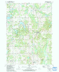
 1991 L'Anse1991 Print · USGSUpper Peninsula life in the early nineties centered on the waters of Keweenaw Bay and the timber-rich highlands of the Huron Mountains. Genealogists and researchers can trace the rail-and-road connections between L'Anse, Baraga, and smaller communities like Pequaming and Assinins.2 unique versions available
 - 1991 Map of Port Huron, 1992 Print
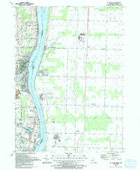
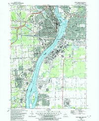 1991 Port Huron1992 Print · USGSThe international border at the St Clair River is captured here during a period of steady industrial and civic growth. Genealogists and historians can trace neighborhood developments near Woodlawn Cem or locate local landmarks like the St Clair Tunnel and Mercy Hospital.
Showing maps 1-25 of 114
Top cities of Michigan
- Detroit historical maps
- Grand Rapids historical maps
- Sterling Heights historical maps
- Warren historical maps
- Ann Arbor historical maps
- Lansing historical maps
See more
Top counties of Michigan
- Wayne County historical maps
- Oakland County historical maps
- Macomb County historical maps
- Kent County historical maps
- Genesee County historical maps
- Washtenaw County historical maps
See more
Frequently asked questions
- What are the different types of historical maps available for Michigan?
- What is the oldest map of Michigan?
- Where can I purchase historical maps of Michigan for my home or office?
- Where can I download high-res historical maps of Michigan?
- Are there historical topographic maps available for Michigan?
- Is there historical aerial imagery available for Michigan?
- Where are historical maps of Michigan sourced from?