1910s Maps of Michigan
Explore 50 historic maps of Michigan from the 1910s. These maps offer a rare glimpse into what life looked like during the 1910s — showing old roads, neighborhoods, homes, and landmarks that have changed or disappeared over time.
Whether you're researching your family's past, planning a metal detecting trip, or studying how Michigan's landscape evolved across the 1910s, these high-resolution maps are a powerful tool for exploring the history of this region.
- Focus on a specific era: All maps on this page are from the 1910s, giving you a focused view of this time period.
- See what’s changed: Compare century-old streets, trails, and buildings to today's modern landscape using overlays and satellite layers.
- Research with precision: Use these maps for genealogy, historical research, land use analysis, or educational projects.
- View, download, or print: Maps are fully viewable online in high resolution, and can be downloaded or printed for your own records.
Start exploring Michigan's history through authentic maps from the 1910s. This is your window into the past.
Michigan maps
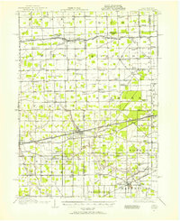
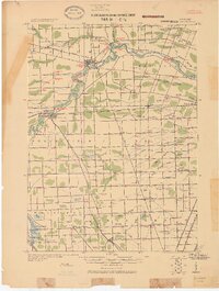
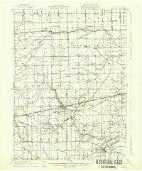
(50)- 1910 Map of Fowlerville
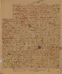
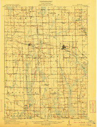 1910 Fowlerville1910 Print · USGSBefore the age of consolidated schools and modern highways, this 1910 survey shows the rural landscape of Ingham and Livingston counties at its peak. Researchers can trace dozens of country schoolhouses like Podunk School and Hogback School alongside the path of the Pere Marquette RR.2 unique versions available
 - 1910 Map of Lansing, 1958 Print
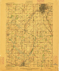
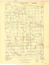
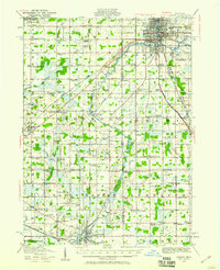 1910 Lansing1958 Print · USGSThe state capital and its surrounding agrarian townships are captured here during a period of significant growth at the start of the 1910s. Genealogists can trace hundreds of family farms and local landmarks including Dolly Varden School, Grovenberg Church, and the Pere Marquette rail lines.
 - 1911 Map of Mason
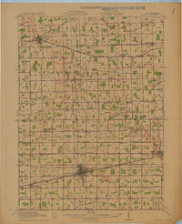
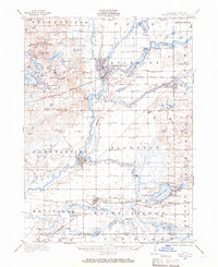
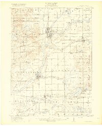
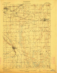 1911 Mason1911 Print · USGSIngham County at the start of the twentieth century shows a landscape of busy rail junctions and rural school districts. Genealogists can trace family roots through dozens of named country schools like White Dog School and Marble School, or locate ancestral property near Mason and Dansville.3 unique versions available
 - 1911 Map of Wauseon, 1954 Print
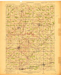
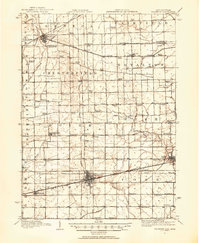 1911 Wauseon1954 Print · USGSFulton County and the Michigan-Ohio borderlands thrived as a major railroad hub in the early twentieth century. Researchers can trace numerous vanished district schools like Swamp Angel School and stop-points like Tedrow PO or Ottokee Sta.
 - 1911 Map of Swanton, 1956 Print
 1911 Swanton1956 Print · USGSNorthwest Ohio and the Michigan border are captured here just before the era of major highway expansion. Genealogists can trace early twentieth-century property locations near Metamora, Raab Corners, and numerous rural schoolhouses like Frogpond School.
 - 1912 Map of Mt Clemens
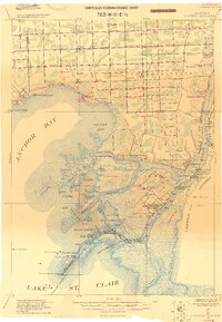
 1912 Mt Clemens1912 Print · USGSMacomb County at the dawn of the aviation age shows a landscape shaped by the winding Clinton River and the arrival of Selfridge Aviation Field. Genealogists and historians can locate legacy settlements like Waldenburg and early industrial sites like the Macomb Sugar Factory.
 - 1912 Map of Wyandotte
 1912 Wyandotte1912 Print · USGSThe industrial corridor south of Detroit thrives along the river just before the Great War. Genealogists and historians can trace the early rail networks of the Michigan Central RR and find specific river landmarks like Grosse Isle and Gibraltar.
 - 1912 Map of Wayne
 1912 Wayne1912 Print · USGSWestern Wayne County in the early twentieth century shows a landscape being reshaped by the first concrete roads and a dense network of electric interurban railways. Trace the early development of Livonia, Redford, and Plymouth, or locate long-standing sites like Eloise and Perrinville.
 - 1912 Map of Monroe
 1912 Monroe1912 Print · USGSMonroe County before the First World War was a landscape defined by its strategic lakefront positioning and a massive concentration of competing railroads. Genealogists can trace the early footprints of Monroe, Brest P.O., and Erie while following local landmarks like Sandy Creek and Plum Creek.
 - 1912 Map of Port Huron
 1912 Port Huron1912 Print · USGSThe St. Clair River border was a hive of rail and river activity just before the Great War. Genealogists and historians can trace early station stops and post offices like Harts Sta., Rankin Sta., and Bickford P.O. across both Michigan and Ontario shores.
 - 1912 Map of Dundee
 1912 Dundee1912 Print · USGSMonroe County was a bustling intersection of rail and river commerce just before the First World War. Local historians can trace the exact routes of the Cincinnati Northern R. R. and the Ann Arbor R. R. as they pass through Dundee and Petersburg.
 - 1912 Map of Lansing
 1912 Lansing1912 Print · USGSLansing and the surrounding townships are captured in 1912 as the region's rural character met the growing industrial city. Genealogists can trace family footprints through dozens of country school sites like Dolly Varden School or settlements such as Dimondale and Canada Settlement.4 unique versions available
 - 1913 Map of Wauseon
 1913 Wauseon1913 Print · USGSFulton County and the Michigan-Ohio border are shown here just before the Great War, during the peak of the region's rural school and rail networks. Genealogists can locate specific family-named landmarks and institutions like Tedrow PO, Ottokee, and the Swamp Angel School.2 unique versions available
 - 1913 Map of Alvordton
 1913 Alvordton1913 Print · USGSThe rural borderlands of Ohio and Michigan are captured here just after the turn of the century, showing a landscape of burgeoning rail junctions and tight-knit farming townships. Researchers can trace the heritage of vanished school districts and country houses of worship like Gray Church and the Mennonite Church near Archbold.3 unique versions available
 - 1913 Map of Sault Sainte Marie, 1919 Print
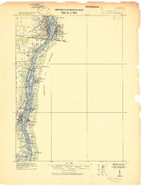
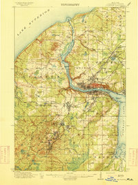
 1913 Sault Sainte Marie1919 Print · USGSUpper Peninsula maritime and rail activity converge at the border in the years before the Great War. Genealogists and local historians can trace early rural post offices and docks like Donaldson P.O., Shine Dock, and the hamlet of McCarron.
 - 1914 Map of Pioneer
 1914 Pioneer1914 Print · USGSNorthwest Ohio and the Michigan borderlands come alive in this pre-war survey of Williams and Hillsdale Counties. Genealogists can trace family farm locations through a dense network of country schools and rail stops like Montpelier, Edon, and the County Infirmary.2 unique versions available
 - 1914 Map of Armada
 1914 Armada1914 Print · USGSMacomb and St. Clair Counties are seen here in the years before the Great War as a productive agricultural landscape tied together by rail. Researchers can trace historic farmstead locations and early rural infrastructure, from Wolcotts Mill Pond to the busy Grand Trunk R. R. junctions at Armada and Richmond.
 - 1914 Map of Algonac
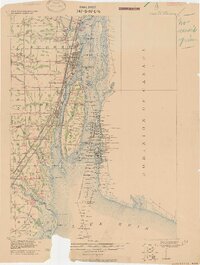
 1914 Algonac1914 Print · USGSThe St. Clair River delta and Harsens Island are captured here before the mid-century shoreline changes. Genealogists can locate family holdings near Starrville or trace the early waterfront developments of Sans Souci P.O. and Tashmoo Park.
 - 1914 Map of Grand Rapids
 1914 Grand Rapids1914 Print · USGSGrand Rapids and its southern townships are captured in detail just before the Great War, showing a landscape defined by river industry and rail lines. Local historians can trace early settlements and schools such as Kelloggsville and Red School, or locate family landmarks near Reeds Lake.5 unique versions available
 - 1914 Map of Monroe, 1928 Print
 1914 Monroe1928 Print · USGSCoastal Michigan between Detroit and Toledo is shown here in the early twentieth century as a bustling hub of rail and river commerce. Genealogists and historians can trace the paths of six different railroads through Monroe and locate the old Brest Post Office near Point Aux Peaux.
 - 1914 Map of Swanton, 1937 Print
 1914 Swanton1937 Print · USGSThe Ohio-Michigan borderlands come alive in this era of peak rail transit and rural schoolhouse density. Genealogists and historians can trace family roots through numerous local landmarks like Metamora, Richfield Center, and uniquely named sites such as Huckleberry School or Frogpond School.
 - 1914 Map of Three Rivers, 1966 Print
 1914 Three Rivers1966 Print · USGSSt. Joseph County's river-driven economy is on full display in the early 1900s, centered on the busy rail junction at Three Rivers. Genealogists can locate dozens of country schools and churches, from Peck Academy to the remote Quail Trap School.
 - 1915 Map of Houghton
 1915 Houghton1915 Print · USGSThe Keweenaw copper boom is in full swing on this map of the Upper Peninsula at the height of its industrial power. Genealogists can trace family roots through company towns like Atlantic Mine, South Range, and Baltic while following the path of the Copper Range RR.4 unique versions available
 - 1916 Map of Three Rivers
 1916 Three Rivers1916 Print · USGSThe river-driven industry and rural school networks of St. Joseph County are in full view during the mid-nineteen-teens. Genealogists and historians can locate old homesteads near Johnnycake School, trace the Chicago Road, or find the early power structures at Sturgis Power Dam.3 unique versions available
 - 1916 Map of Bay City
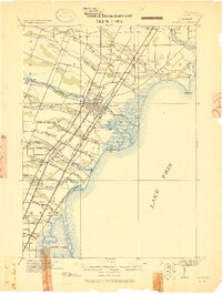
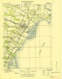
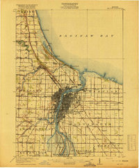 1916 Bay City1916 Print · USGSThe industrial waterfront of Saginaw Bay comes to life in this survey from the years preceding the Great Depression. Genealogists and historians can trace the early footprints of Bay City, locate rural schools like Sugar School, and follow the old Pere Marquette rail lines.
Showing maps 1-25 of 50
Top cities of Michigan
- Detroit historical maps
- Grand Rapids historical maps
- Sterling Heights historical maps
- Warren historical maps
- Ann Arbor historical maps
- Lansing historical maps
See more
Top counties of Michigan
- Wayne County historical maps
- Oakland County historical maps
- Macomb County historical maps
- Kent County historical maps
- Genesee County historical maps
- Washtenaw County historical maps
See more
Frequently asked questions
- What are the different types of historical maps available for Michigan?
- What is the oldest map of Michigan?
- Where can I purchase historical maps of Michigan for my home or office?
- Where can I download high-res historical maps of Michigan?
- Are there historical topographic maps available for Michigan?
- Is there historical aerial imagery available for Michigan?
- Where are historical maps of Michigan sourced from?