1960s Maps of Clay County, Minnesota
Explore 26 historic maps of Clay County from the 1960s. These maps offer a rare glimpse into what life looked like during the 1960s — showing old roads, neighborhoods, homes, and landmarks that have changed or disappeared over time.
Whether you're researching your family's past, planning a metal detecting trip, or studying how Clay County's landscape evolved across the 1960s, these high-resolution maps are a powerful tool for exploring the history of this region.
- Focus on a specific era: All maps on this page are from the 1960s, giving you a focused view of this time period.
- See what’s changed: Compare century-old streets, trails, and buildings to today's modern landscape using overlays and satellite layers.
- Research with precision: Use these maps for genealogy, historical research, land use analysis, or educational projects.
- View, download, or print: Maps are fully viewable online in high resolution, and can be downloaded or printed for your own records.
Start exploring Clay County's history through authentic maps from the 1960s. This is your window into the past.
Clay County, MN maps
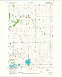
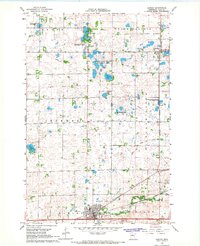
(26)- 1963 Map of Georgetown, 1964 Print
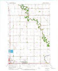
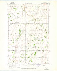
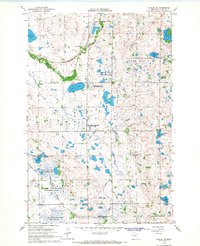
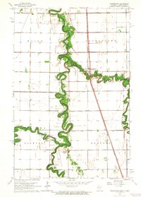 1963 Georgetown1964 Print · USGSThe Red River Valley's winding borderlands are captured here in the early sixties, showing the fertile divide between Minnesota and North Dakota. Researchers can trace the paths of the Great Northern railroad and locate community sites like Osterdalen Ch and Osterdalen Cem.
 - 1963 Map of Perley, 1964 Print
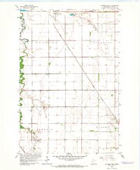
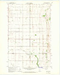
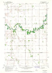
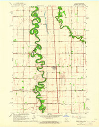 1963 Perley1964 Print · USGSThe Red River Valley at the Minnesota border comes into focus during the early sixties, showing the tight meanders of the Red River and Wild Rice River. Trace local history through the Great Northern rail stops, Perley townsite, and Kirkebo Cem.2 unique versions available
 - 1964 Map of Sabin, 1966 Print
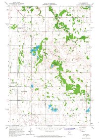
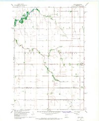
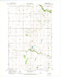
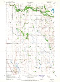
 1964 Sabin1966 Print · USGSClay County in the mid-1960s is shown here as a landscape of rail-driven settlements and vital drainage works. You can trace the path of the Northern Pacific through Sabin or locate early landmarks like the Moorhead Airport and the local Dragstrip.3 unique versions available
 - 1964 Map of Baker, 1966 Print
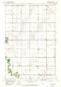
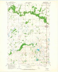
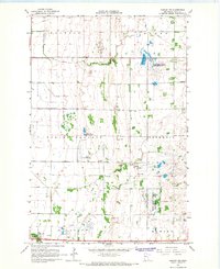
 1964 Baker1966 Print · USGSClay County's agricultural heartland is documented here in the mid-sixties, centered on the rail-side settlement of Baker. Researchers can trace the path of the Great Northern railroad and the winding courses of Whisky Creek and the South Branch Buffalo River.3 unique versions available
 - 1964 Map of Dilworth, 1966 Print
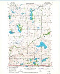
 1964 Dilworth1966 Print · USGSClay County at the height of the mid-century rail era shows a landscape shaped by the winding Buffalo River and the expanding town of Dilworth. Researchers can trace the local rail networks through Kragnes and locate family homesteads along the rural sectional roads.3 unique versions available
 - 1964 Map of Glyndon South, 1966 Print
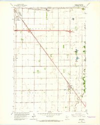
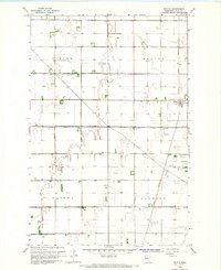
 1964 Glyndon South1966 Print · USGSClay County's agricultural heartland is documented here in the mid-1960s, centered on the vital rail junction at Glyndon. Researchers can trace local heritage through the locations of the Elmwood Cem, Trinity Ch, and the many sections of the Great Northern railroad.
 - 1964 Map of Comstock, 1966 Print
 1964 Comstock1966 Print · USGSThe Red River Valley prairie in the mid-sixties shows a landscape shaped by the Great Northern rail line and complex drainage. Genealogists can locate the Comstock Cem and the small siding at Rustad along the Iron Horse route.
 - 1964 Map of Glyndon North, 1966 Print
 1964 Glyndon North1966 Print · USGSClay County's agricultural landscape is seen here in the mid-sixties, dominated by the precision of the Red River Valley's drainage grid. Researchers can trace family roots near Glyndon at Riverside Cem or follow the Great Northern rail line through Averill.2 unique versions available
 - 1965 Map of Syre, 1967 Print
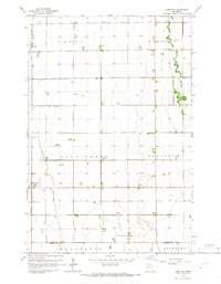
 1965 Syre1967 Print · USGSNorthwestern Minnesota's agricultural landscape is captured in the mid-sixties, centered on the Northern Pacific railroad. Genealogists and local historians can trace the settlement of Syre, locate a rural Cem, or identify the township Townhall.
 - 1965 Map of Ulen NW, 1967 Print
 1965 Ulen NW1967 Print · USGSNorman County agriculture was in full bloom in the mid-sixties, defined by a vast network of drainage ditches and the growth of the village of Borup. Genealogists can locate family landmarks like Jevnaker Ch and the South Branch Wild Rice River.
 - 1966 Map of Flom, 1963 Print
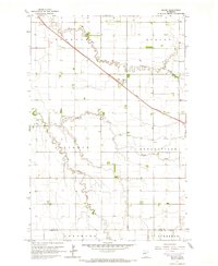
 1966 Flom1963 Print · USGSThe rural borderlands of Norman, Clay, and Becker counties are captured here in the mid-1960s. Genealogists and local historians can trace family roots through sites like Wild Rice Ch, Bethlehem Cem, and the old Townhall.2 unique versions available
 - 1966 Map of Grand Forks
 1966 Grand Forks1966 Print · USGSThe Red River Valley in the mid-sixties shows a landscape shaped by rail-line commerce and complex water management. Genealogists and historians can trace rail-side towns like Emerado and Hunter or locate rural landmarks like the Pleasant View Church.
 - 1966 Map of Felton SW, 1967 Print
 1966 Felton SW1967 Print · USGSClay County's rural townships are captured in the mid-1960s as the prairie landscape became a highly organized agricultural grid. Researchers can locate the North Buffalo Ch and a central Townhall set against the winding path of the Buffalo River.
 - 1966 Map of Tilde Lake, 1967 Print
 1966 Tilde Lake1967 Print · USGSThe borderlands of Clay and Becker counties come alive in the mid-1960s, showing a landscape of glacial lakes and prairie drainage. Researchers can trace rural life through the Atlanta Ch, the local Townhall, and the expansive Goose Prairie State Wildlife Management Area.
 - 1966 Map of Felton NW, 1967 Print
 1966 Felton NW1967 Print · USGSThe Red River Valley prairie of Norman and Clay Counties is shown in the mid-1960s as a highly engineered agricultural landscape. Genealogists can trace rural landmarks like Landstad Ch, St Marys Cem, and the winding Wild Rice River.
 - 1966 Map of Borup, 1967 Print
 1966 Borup1967 Print · USGSBorup and the surrounding Red River Valley townships are shown in the mid-1960s as a landscape of precision agriculture and rail transport. Researchers can trace the Great Northern tracks and find local landmarks like Winchester Cem or the winding Wild Rice River.
 - 1966 Map of Ulen, 1967 Print
 1966 Ulen1967 Print · USGSClay County prairie life in the sixties is centered on the railroad town of Ulen and the winding Wild Rice River. Genealogists and historians can trace local landmarks like Sleeper Cem, Keene Ch, and the tracks of the Northern Pacific.
 - 1966 Map of Hawley SE, 1967 Print
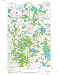
 1966 Hawley SE1967 Print · USGSClay County's lake-strewn prairie is captured here in the 1960s, showing a landscape of scattered family farms and vast wildlife preserves. Genealogists can locate the Silver Lake Pioneer Cem, Zion Cem, and the historic Northern Pacific rail line.
 - 1966 Map of Ulen SW, 1967 Print
 1966 Ulen SW1967 Print · USGSClay County's agricultural and natural borders are captured here in the mid-1960s as drainage systems transformed the prairie. Genealogists and researchers can locate the Felton Cem, trace the meandering South Branch Wild Rice River, or study the early boundaries of the Felton State Wildlife Management Area.
 - 1966 Map of Hawley NW, 1967 Print
 1966 Hawley NW1967 Print · USGSClay County's rural townships are captured in the mid-1960s, showing a landscape defined by agricultural drainage and prairie conservation. Genealogists and local researchers can trace family sites at Lysne Cem and Spring Prairie Cem or follow the Buffalo River.2 unique versions available
 - 1966 Map of Dale, 1967 Print
 1966 Dale1967 Print · USGSRailroad hubs and prairie wetlands converge in Clay County during the mid-sixties, capturing the height of the regional rail network. Genealogists and historians can trace the foundations of local life at Manitoba Junction, Dale, and the Highland Grove Ch.
 - 1966 Map of Hawley, 1967 Print
 1966 Hawley1967 Print · USGSClay County at the height of the 1960s shows a landscape of prairie townships and rail-oriented commerce. Local researchers can trace family landmarks like Cem Lysne Ch and the Northern Pacific line running through Hitterdal and Hawley.
 - 1966 Map of Downer, 1968 Print
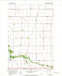
 1966 Downer1968 Print · USGSClay County's prairie and river landscape is captured here in the mid-1960s, showing a region defined by rail lines and water management. Researchers can trace the legacy of the Northern Pacific railroad through Muskoda or explore the early boundaries of Buffalo River State Park.2 unique versions available
 - 1966 Map of Felton, 1968 Print
 1966 Felton1968 Print · USGSClay County's agricultural heartland is captured here in the mid-sixties, showing the intricate drainage and rail systems that built the local economy. Researchers can trace family roots through the Felton Cem, Scandia Cem, and the Great Northern rail corridor.
 - 1966 Map of Lake Park SW, 1968 Print
 1966 Lake Park SW1968 Print · USGSThe lake-strewn border of Clay and Becker counties is captured here in the mid-1960s, showing a landscape shaped by Scandinavian heritage and glacial geology. Researchers can locate family landmarks like Solem Ch and Christ Olson Lake, or trace the development of rural roads past the Townhall and local Gravel Pits.
Showing maps 1-25 of 26
Top cities of Clay County
- Moorhead historical maps
- Dilworth historical maps
- Barnesville historical maps
- Hawley historical maps
- Glyndon historical maps
- Ulen historical maps
See more
Frequently asked questions
- What are the different types of historical maps available for Clay County?
- What is the oldest map of Clay County?
- Where can I purchase historical maps of Clay County for my home or office?
- Where can I download high-res historical maps of Clay County?
- Are there historical topographic maps available for Clay County?
- Is there historical aerial imagery available for Clay County?
- Where are historical maps of Clay County sourced from?