1980s Maps of Sheridan County, Nebraska
Explore 26 historic maps of Sheridan County from the 1980s. These maps offer a rare glimpse into what life looked like during the 1980s — showing old roads, neighborhoods, homes, and landmarks that have changed or disappeared over time.
Whether you're researching your family's past, planning a metal detecting trip, or studying how Sheridan County's landscape evolved across the 1980s, these high-resolution maps are a powerful tool for exploring the history of this region.
- Focus on a specific era: All maps on this page are from the 1980s, giving you a focused view of this time period.
- See what’s changed: Compare century-old streets, trails, and buildings to today's modern landscape using overlays and satellite layers.
- Research with precision: Use these maps for genealogy, historical research, land use analysis, or educational projects.
- View, download, or print: Maps are fully viewable online in high resolution, and can be downloaded or printed for your own records.
Start exploring Sheridan County's history through authentic maps from the 1980s. This is your window into the past.
Sheridan County, NE maps
(26)- 1985 Map of Gordon
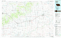 1985 Gordon1985 Print · USGSSheridan County and the High Plains thrive along the rail lines during the mid-eighties as agriculture and aviation modernize the region. Trace family roots and land patterns near Rushville, the Nebraska National Forest, and the Old Indian Treaty Boundary.2 unique versions available
 - 1985 Map of Alliance, 1986 Print
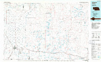 1985 Alliance1986 Print · USGSThe High Plains of Box Butte and Sheridan counties come alive in the mid-1980s, centered on the rail hub of Alliance. Genealogists and historians can trace the Burlington Northern line through small sidings and towns like Antioch, Lakeside, and Bingham near the Niobrara River.2 unique versions available
 - 1989 Map of White Lake
 1989 White Lake1989 Print · USGSSheridan County's high plains ranching country is mapped here in the late eighties, showing a landscape of scattered basins and grazing land. Researchers can trace historic ranch footprints at Star Ranch and Wilson Ranch or locate family-named water bodies like Van Loon Lake and Roethler Lake.
 - 1989 Map of Skunk Lake
 1989 Skunk Lake1989 Print · USGSSheridan County at the end of the 1980s reveals a specialized landscape of Sandhills wetlands and remote ranchland. Researchers can trace the water levels and boundaries of Skunk Lake, Long Lake, and Dillings Lake during this era.
 - 1989 Map of Jesse Lke
 1989 Jesse Lke1989 Print · USGSSheridan County's unique Sandhills geography is captured here in the late eighties, showing the remote settlement of Hoffland. Researchers can trace the drainage of Snake Creek and locate several named basins including Jesse Lake and Lee Sturgeon Lake.
 - 1989 Map of Gaunt Lake
 1989 Gaunt Lake1989 Print · USGSThe Nebraska Sandhills come alive in the 1980s, showing a landscape defined by ranching and unique hydrology. Genealogists and researchers can trace the roads around Koch Ranch or explore the numerous wetlands like Gaunt Lake and Kennedy Lake.
 - 1989 Map of Peter Long Lake
 1989 Peter Long Lake1989 Print · USGSSheridan County ranchlands are captured here in the late eighties, showing a landscape defined by sand dunes and isolated water bodies. Researchers can trace historic ranch boundaries like Arapahoe Ranch and Cody Ranch or locate water sources like Dennis Lake.
 - 1989 Map of Lakeside
 1989 Lakeside1989 Print · USGSLakeside and the surrounding Nebraska Sandhills are captured here in the late eighties as a landscape of rail-side settlement and scattered wetlands. Genealogists and local historians can trace family-named landmarks like Ashburger Lake and Thompson Lake along the Burlington Northern line.
 - 1989 Map of Billys Lake
 1989 Billys Lake1989 Print · USGSSheridan County ranching country is mapped here in the late twentieth century, showing a remote landscape of sandhill lakes and family holdings. Genealogists can trace historic estates like Piper Ranch and Strasburger Ranch alongside Billys Lake.
 - 1989 Map of Krause Lake East
 1989 Krause Lake East1989 Print · USGSSheridan County's high plains are revealed in the late eighties as a complex network of wetlands and namesake basins. Researchers can trace the water-dependent landscape through features like Tree Claim Lake, School Section Lake, and the Wilkinson Lakes.
 - 1989 Map of Skunk Lake NE
 1989 Skunk Lake NE1989 Print · USGSSheridan County ranching country is captured here during the late eighties, showing the remote plains north of the Niobrara. Researchers can locate family landmarks like the Sandoz Ranch and trace the drainage of Box Butte Creek and the Niobrara River.
 - 1989 Map of Argo Hill
 1989 Argo Hill1989 Print · USGSThe Nebraska Sandhills come alive in the late eighties through this record of family-run ranching estates and high-plains valleys. Genealogists and historians can trace the footprints of the Dukat Ranch, F Sandoz Ranch, and Mooney Ranch across the Highland Flats.
 - 1989 Map of Skunk Lake SW
 1989 Skunk Lake SW1989 Print · USGSSheridan and Box Butte counties are shown here in the late eighties, dominated by expansive ranching operations. Genealogists and local historians can trace family landholdings like the K Messersmith Ranch and Twin Lakes Ranch or locate the site of School No 100.
 - 1989 Map of Twin Lakes
 1989 Twin Lakes1989 Print · USGSSheridan County ranching country is documented here in the late eighties, showing a landscape defined by the Nebraska Sandhills water system. Genealogists can locate family landmarks like Speer Ranch and Hopper Ranch or the rural Sch No 127.
 - 1989 Map of Wolford Valley
 1989 Wolford Valley1989 Print · USGSSheridan County ranching country is documented here in the late twentieth century, showing a landscape defined by cattle operations and isolated homesteads. Genealogists and historians can trace family holdings like the Hamilton Ranch and the location of the Spade Sch.
 - 1989 Map of Krause Lake West
 1989 Krause Lake West1989 Print · USGSThe Nebraska Sandhills come into focus along the border of Box Butte and Sheridan counties in the late 1980s. Researchers can trace the section-line roads and unique water features of this ranching country, including Twin Lakes, Krause Lake, and the southern Fenner Lakes.
 - 1989 Map of Antioch
 1989 Antioch1989 Print · USGSAntioch and the surrounding Sandhills ranches are captured here in the late eighties, showing a landscape defined by alkaline lakes and isolated homesteads. Genealogists and local historians can trace the Johnston Ranch, the settlement of Antioch, and the Burlington Northern rail line.
 - 1989 Map of Twin Lakes NE
 1989 Twin Lakes NE1989 Print · USGSSheridan County ranching country is captured here during the late 1980s, showing the vast grazing lands of the Nebraska Sandhills. Local historians and genealogists can trace family operations at Nelson Ranch or Forney Ranch and locate the remote Landing Strip and water Well sites.
 - 1989 Map of Dolly Warden Lake
 1989 Dolly Warden Lake1989 Print · USGSSheridan County ranching country is captured here in the late eighties, centered on the historic Sandoz family lands. Genealogists and historians can trace local landmarks like the Mari Sandoz Museum, Sch No 166, and the Spring Lake Ranch.
 - 1989 Map of Smith Lake
 1989 Smith Lake1989 Print · USGSSheridan County ranching country is mapped here in the late eighties, showing a landscape of family-held lands and water resources. Genealogists and historians can locate specific homesteads like the Budd Ranch or trace the boundaries of the Smith Lake State Wildlife Management Area.
 - 1989 Map of Bingham
 1989 Bingham1989 Print · USGSThe remote ranching country surrounding Bingham is captured here as it appeared in the late eighties. Genealogists and local historians can trace legacy properties like Sellers Ranch, Powles Ranch, and the isolated Willy Ranch among the many named lakes of the Nebraska Sandhills.
 - 1989 Map of Skunk Lake NW
 1989 Skunk Lake NW1989 Print · USGSThe Nebraska Panhandle's high plains and river valleys are captured here in the late 1980s. Researchers can trace the sophisticated irrigation network of the Sturgeon Canal and the meandering course of Box Butte Creek.
 - 1989 Map of Green Lake
 1989 Green Lake1989 Print · USGSSheridan County ranching country is mapped here in the late twentieth century as a landscape of large cattle operations and scattered basin lakes. Genealogists and local historians can trace legacy land holdings like the Berndt Cattle Co Ranch or find the remote Sch No 133.
 - 1989 Map of Lowe Valley
 1989 Lowe Valley1989 Print · USGSThe Nebraska sandhills along the border of Sheridan and Cherry counties are captured here in the late eighties. Researchers can locate isolated ranching landmarks like Andrick Ranch, Becker Field, and the waters of Granning Lake tucked within the hills.
 - 1989 Map of Arnold Lake
 1989 Arnold Lake1989 Print · USGSSheridan County ranching country is shown here in the late twentieth century, when family-named holdings defined the Nebraska Sandhills. Genealogists and local historians can trace legacy properties like the Brennan Ranch and Nielson Ranch alongside the Leisy Sch No 154.
Showing maps 1-25 of 26
Top cities of Sheridan County
Frequently asked questions
- What are the different types of historical maps available for Sheridan County?
- What is the oldest map of Sheridan County?
- Where can I purchase historical maps of Sheridan County for my home or office?
- Where can I download high-res historical maps of Sheridan County?
- Are there historical topographic maps available for Sheridan County?
- Is there historical aerial imagery available for Sheridan County?
- Where are historical maps of Sheridan County sourced from?