1900-1909 Maps of Niagara County, New York
Explore 7 historic maps of Niagara County from 1900-1909. These maps offer a rare glimpse into what life looked like during the 1900s — showing old roads, neighborhoods, homes, and landmarks that have changed or disappeared over time.
Whether you're researching your family's past, planning a metal detecting trip, or studying how Niagara County's landscape evolved across the 1900s, these high-resolution maps are a powerful tool for exploring the history of this region.
- Focus on a specific era: All maps on this page are from the 1900s, giving you a focused view of this time period.
- See what’s changed: Compare century-old streets, trails, and buildings to today's modern landscape using overlays and satellite layers.
- Research with precision: Use these maps for genealogy, historical research, land use analysis, or educational projects.
- View, download, or print: Maps are fully viewable online in high resolution, and can be downloaded or printed for your own records.
Start exploring Niagara County's history through authentic maps from the 1900s. This is your window into the past.
Niagara County, NY maps
(7)- 1900 Map of Wilson
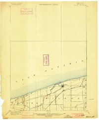 1900 Wilson1900 Print · USGSNiagara County's shoreline at the turn of the century shows a landscape of established orchards and quiet lakefront ports. Genealogists can trace the early layout of Wilson and North Wilson or locate the Rome Watertown and Ogdensburg Station along the rail line.5 unique versions available
 - 1900 Map of Tonawanda
 1900 Tonawanda1900 Print · USGSNiagara County and northern Erie County are shown at the turn of the century as the Erie Canal and heavy rail lines drove the growth of the North Tonawanda lumber and shipping hub. Genealogists can trace family footprints in outlying hamlets like Bergholtz, Ransomville, and Martinsville.
 - 1900 Map of Niagara Falls, 1961 Print
 1900 Niagara Falls1961 Print · USGSThe Niagara frontier at the turn of the century shows an intense convergence of industrial power and military history along the international border. Trace the rail-and-river economy through the Suspension Bridge and Michigan Central R. R. or locate old landmarks like Fort Niagara and the Whirlpool.4 unique versions available
 - 1901 Map of Niagara Falls
 1901 Niagara Falls1901 Print · USGSThe Niagara frontier at the dawn of the twentieth century is captured here in striking detail, from the river's mouth to the falls. Trace the dense rail networks of the Niagara Falls area or locate Fort Niagara and the Brock Monument.11 unique versions available
 - 1901 Map of Tonawanda
 1901 Tonawanda1901 Print · USGSAt the turn of the century, the Niagara Frontier was a powerhouse of canal and rail transit. Genealogists can trace family footprints in settlements like Sanborn, Martinsville, and Bergholtz, or follow the original path of the ERIE CANAL through Tonawanda.7 unique versions available
 - 1902 Map of Lockport
 1902 Lockport1902 Print · USGSNiagara and Erie Counties thrived at the turn of the century as the Erie Canal and heavy rail transformed the region. Researchers can trace ancestral property near Lockport or locate vanished stops along the Batavia and Tonawanda Shore Line and near Reynales Basin.6 unique versions available
 - 1905 Map of Lockport, 1906 Print
 1905 Lockport1906 Print · USGSNiagara and Erie counties at the height of the canal and rail era show a landscape defined by the Erie Canal. Trace family roots in Lockport or explore early transit networks through Transit Sta., Akron, and the Electric R. R.
End of results
Showing maps 1-7 of 7
Top cities of Niagara County
- Niagara Falls historical maps
- North Tonawanda historical maps
- Lockport historical maps
- Lockport historical maps
- Wheatfield historical maps
- Lewiston historical maps
See more
Frequently asked questions
- What are the different types of historical maps available for Niagara County?
- What is the oldest map of Niagara County?
- Where can I purchase historical maps of Niagara County for my home or office?
- Where can I download high-res historical maps of Niagara County?
- Are there historical topographic maps available for Niagara County?
- Is there historical aerial imagery available for Niagara County?
- Where are historical maps of Niagara County sourced from?