1980s Maps of Niagara County, New York
Explore 14 historic maps of Niagara County from the 1980s. These maps offer a rare glimpse into what life looked like during the 1980s — showing old roads, neighborhoods, homes, and landmarks that have changed or disappeared over time.
Whether you're researching your family's past, planning a metal detecting trip, or studying how Niagara County's landscape evolved across the 1980s, these high-resolution maps are a powerful tool for exploring the history of this region.
- Focus on a specific era: All maps on this page are from the 1980s, giving you a focused view of this time period.
- See what’s changed: Compare century-old streets, trails, and buildings to today's modern landscape using overlays and satellite layers.
- Research with precision: Use these maps for genealogy, historical research, land use analysis, or educational projects.
- View, download, or print: Maps are fully viewable online in high resolution, and can be downloaded or printed for your own records.
Start exploring Niagara County's history through authentic maps from the 1980s. This is your window into the past.
Niagara County, NY maps
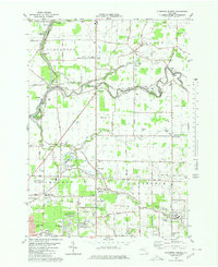
(14)- 1980 Map of Cambria
 1980 Cambria1980 Print · USGSNiagara County in the early eighties shows a mix of Cold War military presence and educational growth. Researchers can trace the layout of the Lockport Air Force Station, find St Peters Ch, or explore the CONRAIL rail corridor.
 - 1980 Map of Tonawanda West
 1980 Tonawanda West1980 Print · USGSThe Niagara River frontier in the early 1980s reveals a landscape of heavy industry, military aviation, and growing suburbs. Researchers can trace historic cemeteries like Holy Ghost Cem, local schools such as Duffy High Sch, and the layout of Grand Island.
 - 1980 Map of Clarence Center
 1980 Clarence Center1980 Print · USGSSuburban development meets rural Erie County during the early eighties as new residential tracts rise near established crossroads. Researchers can trace the Erie Canal near the Sulphur Springs Guard Lock or locate family roots at St Marys Cem and Clarence Center.
 - 1980 Map of Ransomville
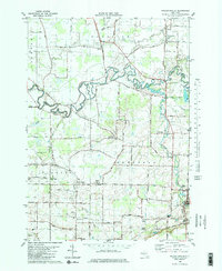
 1980 Ransomville1980 Print · USGSNiagara County's agricultural and industrial character is preserved here in the early eighties, from the Lake Ontario plains to the Tuscarora escarpment. Trace local family roots and historical land use through landmarks like Mt Hope Cem, the settlement at Model City, and the Tuscarora Indian Reservation.2 unique versions available
 - 1980 Map of Barker
 1980 Barker1980 Print · USGSNiagara County's fertile lakeside plains are captured here in the early eighties, showing the rural communities of Barker and Somerset. Researchers can locate family landmarks such as the Quaker Cemetery, the Quaker Road Church, and the unique Barker Central School Airport.
 - 1980 Map of Lockport
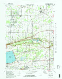
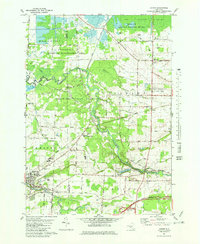
 1980 Lockport1980 Print · USGSLockport and the surrounding Niagara County countryside are captured here in the early eighties, showing the city's industrial core and rural townships. Researchers can trace local landmarks like St Bridgets Ch, the County Fairgrounds, and the path of the ERIE CANAL.3 unique versions available
 - 1980 Map of Wolcottsville
 1980 Wolcottsville1980 Print · USGSThe rural borders of Erie and Niagara counties come alive in the late twentieth century as this survey follows the winding Tonawanda Creek. Trace the sites of Swifts Mills, Dancer Cem, and the old rail connections at Akron Junction.2 unique versions available
 - 1980 Map of Ft Niagara
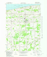
 1980 Ft Niagara1980 Print · USGSThe international border at the mouth of the Niagara River is captured here in the 1980s, showing a landscape defined by military history and lakefront growth. Researchers can trace the layout of Niagara-On-The-Lake, Youngstown, and the grounds of Fort Niagara State Park.
 - 1980 Map of Tonawanda East
 1980 Tonawanda East1980 Print · USGSNiagara and Erie counties meet at the historic canal in the early eighties as suburban growth reshapes the landscape. Genealogists and local historians can trace the development of North Tonawanda, the grounds of White Chapel Memorial Cem, and small hamlets like Wendelville.
 - 1980 Map of Lewiston, 1981 Print
 1980 Lewiston1981 Print · USGSNiagara County and the international border are seen here in the 1980s, showcasing the massive power infrastructure along the river. Genealogists and researchers can locate Riverdale Cemetery, Stella Niagara Seminary, and the unique Our Lady of Fatima Shrine.
 - 1980 Map of Niagara Falls, 1981 Print
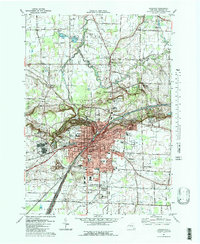
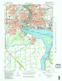 1980 Niagara Falls1981 Print · USGSNiagara Falls and its international surrounds are captured in the early eighties as a hub of hydropower and tourism. Genealogists and historians can trace neighborhood schools like Gaskill High School, resting places like Oakwood Cemetery, and rail junctions at Montrose Junction.
 - 1981 Map of Akron
 1981 Akron1981 Print · USGSThe Erie and Genesee county border in the early eighties centers on the Tonawanda Indian Reservation and the industrial village of Akron. Genealogists and historians can trace family sites at Four Corners Cem or locate industrial relics like the Mine Shaft near Basom.
 - 1984 Map of Lockport, 1985 Print
 1984 Lockport1985 Print · USGSWestern New York in the 1980s shows a landscape of lakefront parks, industrial rail corridors, and vast protected wetlands. Genealogists and historians can trace the legacy of local families through sites like Acacia Park Cem or the Tuscarora Indian Reservation.2 unique versions available
 - 1986 Map of Niagara Falls
 1986 Niagara Falls1986 Print · USGSThe Niagara frontier in the mid-eighties shows a landscape of heavy power generation and riverfront parkland. Trace the residential growth of Lewiston and Youngstown or locate landmarks like Old Fort Niagara and the Niagara Escarpment.2 unique versions available
End of results
Showing maps 1-14 of 14
Top cities of Niagara County
- Niagara Falls historical maps
- North Tonawanda historical maps
- Lockport historical maps
- Lockport historical maps
- Wheatfield historical maps
- Lewiston historical maps
See more
Frequently asked questions
- What are the different types of historical maps available for Niagara County?
- What is the oldest map of Niagara County?
- Where can I purchase historical maps of Niagara County for my home or office?
- Where can I download high-res historical maps of Niagara County?
- Are there historical topographic maps available for Niagara County?
- Is there historical aerial imagery available for Niagara County?
- Where are historical maps of Niagara County sourced from?