2020s Maps of Niagara County, New York
Explore 19 historic maps of Niagara County from the 2020s. These maps offer a rare glimpse into what life looked like during the 2020s — showing old roads, neighborhoods, homes, and landmarks that have changed or disappeared over time.
Whether you're researching your family's past, planning a metal detecting trip, or studying how Niagara County's landscape evolved across the 2020s, these high-resolution maps are a powerful tool for exploring the history of this region.
- Focus on a specific era: All maps on this page are from the 2020s, giving you a focused view of this time period.
- See what’s changed: Compare century-old streets, trails, and buildings to today's modern landscape using overlays and satellite layers.
- Research with precision: Use these maps for genealogy, historical research, land use analysis, or educational projects.
- View, download, or print: Maps are fully viewable online in high resolution, and can be downloaded or printed for your own records.
Start exploring Niagara County's history through authentic maps from the 2020s. This is your window into the past.
Niagara County, NY maps
(19)- 2023 Map of Cambria, 2023 Print
 2023 Cambria2023 Print · USGSNiagara County rural life is captured here in the early 2020s, showcasing a landscape of established hamlets and deep family roots. Researchers can locate numerous historical burial sites like Hillside Cem of Cambria and the North Ridge Cem near Cambria Center.
 - 2023 Map of Gasport, 2023 Print
 2023 Gasport2023 Print · USGSNiagara County's canal-era heritage remains visible in this contemporary record of the towns and hamlets east of Lockport. Researchers can trace historic family burial sites like Mabee Cem and Huskey Cem while following the path of the Erie Canal through Reynales Basin.
 - 2023 Map of Clarence Center, 2023 Print
 2023 Clarence Center2023 Print · USGSClarence Center and the surrounding Erie County suburbs appear in great detail during the early twenty-first century. Researchers can locate family sites at Saint Pauls Cem, trace the Erie Canal, or explore the airfield at Clarence Aerodrome.
 - 2023 Map of Lockport, 2023 Print
 2023 Lockport2023 Print · USGSNiagara County's canal-driven landscape is captured here, centered on the urban core of Lockport and its surrounding suburban communities. Researchers can trace historic cemeteries like Glenwood Cem or locate civic landmarks such as the Niagara County Courthouse and Bent-Wing Airport.
 - 2023 Map of Newfane, 2023 Print
 2023 Newfane2023 Print · USGSThe Niagara County shoreline meets Lake Ontario in this contemporary survey of the Newfane area. Researchers can trace family history at Lakeview Cem or Hess Cem and locate landmarks like the Olcott-Newfane Airport and Saint Charles Borromeo.
 - 2023 Map of Lyndonville, 2023 Print
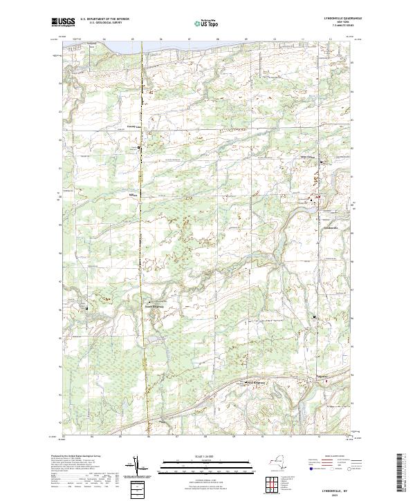 2023 Lyndonville2023 Print · USGSThe Lake Ontario shoreline and the rural orchards of Orleans County are captured in this contemporary survey. Genealogists can trace family sites near Yates Center Cem and Saint Patrick's Cem, or explore the village life of Lyndonville.
 - 2023 Map of Fort Niagara, 2023 Print
 2023 Fort Niagara2023 Print · USGSThe Niagara River mouth meets the international border at the New York-Canada line in this recent topographic survey. Local historians can trace the shoreline developments near Youngstown, the historic Fort Niagara Cem, and the waters of Two Mile Pond.
 - 2023 Map of Barker, 2023 Print
 2023 Barker2023 Print · USGSNiagara County's fruit-growing belt along the Lake Ontario shoreline comes into focus in this contemporary survey. Genealogists can locate family plots at Quaker Cem or trace the rural landscape near Barker and North Hartland.
 - 2023 Map of Wilson, 2023 Print
 2023 Wilson2023 Print · USGSNiagara County’s northern lakefront is documented here in recent years, showing the established communities and shoreline developments along Lake Ontario. Genealogists and historians can trace the streets of Wilson, locate Greenwood Cem, and map the coastal reaches of Sunset Beach and Tuscarora Bay.
 - 2023 Map of Sixmile Creek, 2023 Print
 2023 Sixmile Creek2023 Print · USGSNiagara County's northern shore meets the Great Lakes in the early twenty-first century, showing a landscape of small coastal hamlets and inland creek valleys. Researchers can trace local landmarks from Ransomville up to the shoreline at Uneeda Beach and Harrison Grove.
 - 2023 Map of Tonawanda West, 2023 Print
 2023 Tonawanda West2023 Print · USGSThe Niagara River and its island communities are captured here in the early twenty-first century. Genealogists can locate family names at Saint Paul Lutheran Church Cem or trace the early street grids of Bergholtz and Grandyle Village.
 - 2023 Map of Medina, 2023 Print
 2023 Medina2023 Print · USGSThe Erie Canal corridor comes to life in this contemporary survey of the Niagara and Orleans county border. Genealogists and historians can trace family plots at Boxwood Cem or Sacred Heart Cem and explore canal-side settlements like Middleport and Shelby Basin.
 - 2023 Map of Tonawanda East, 2023 Print
 2023 Tonawanda East2023 Print · USGSThe Niagara-Erie county line comes into focus here along the winding path of Tonawanda Creek in the 2020s. Researchers can trace the development of suburban enclaves like Wurlitzer Park Village and Willow Ridge Estates alongside the massive University at Buffalo campus.
 - 2023 Map of Ransomville, 2023 Print
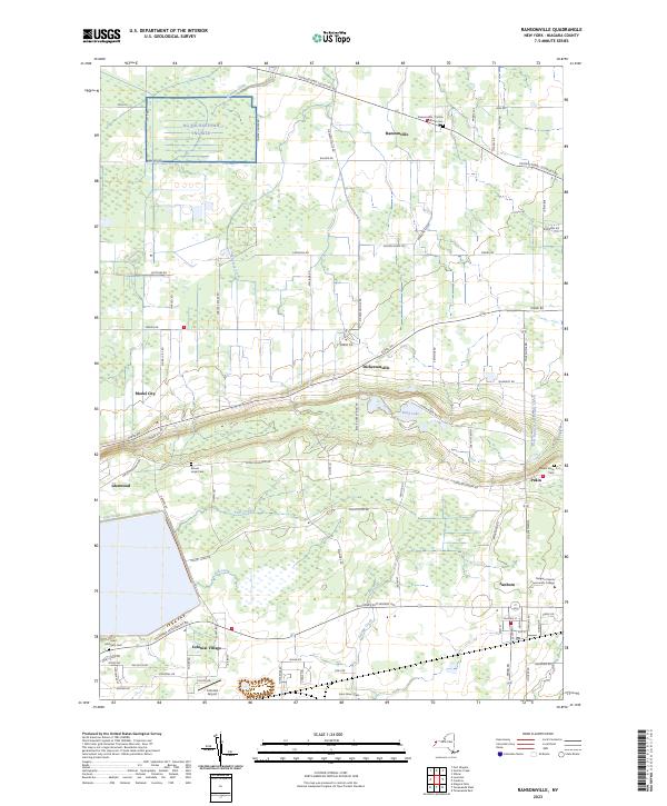 2023 Ransomville2023 Print · USGSNiagara County's rural landscape comes into focus in this contemporary survey of the hamlets and farms north of the Niagara Escarpment. Researchers can locate early burial sites like Mount Hope Cem and trace the development of Model City and Sanborn.
 - 2023 Map of Akron, 2023 Print
 2023 Akron2023 Print · USGSThe borderlands of Erie and Genesee Counties come into focus in the early twenty-first century, showcasing the village of Akron and the Oak Orchard Swamp. Genealogists can trace burial records at Saint Teresas Roman Catholic Cem or the Four Corners Cem.
 - 2023 Map of Wolcottsville, 2023 Print
 2023 Wolcottsville2023 Print · USGSThe Erie and Niagara county line runs through this landscape of creek-side hamlets and rural crossroads in the early 2020s. Trace local history at Wolcottsville, Swifts Mills, and the Trinity Lutheran Cem near the banks of Tonawanda Creek.
 - 2023 Map of Lyndonville OE N, 2023 Print
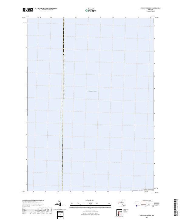 2023 Lyndonville OE N2023 Print · USGSThe open waters of the Niagara County shoreline are captured in this recent survey. Maritime researchers and cartography collectors can trace the vast reach of Lake Ontario as it appeared in the early 2020s.
 - 2023 Map of Niagara Falls, 2023 Print
 2023 Niagara Falls2023 Print · USGSNiagara Falls and its immediate riverfront are captured here in the early twenty-first century, showing the modern urban grid meeting the falls. Researchers can trace local landmarks like Oakwood Cem, the Angelo Delignore Civic Building, and islands such as Goat Island and Buckhorn Island.
 - 2023 Map of Lewiston, 2023 Print
 2023 Lewiston2023 Print · USGSThe Niagara frontier in the early 2020s shows a landscape of deep historical roots and international borders. Researchers can locate numerous local landmarks including Niagara University, Stella Niagara, and the Devils Hole gorge.
End of results
Showing maps 1-19 of 19
Top cities of Niagara County
- Niagara Falls historical maps
- North Tonawanda historical maps
- Lockport historical maps
- Lockport historical maps
- Wheatfield historical maps
- Lewiston historical maps
See more
Frequently asked questions
- What are the different types of historical maps available for Niagara County?
- What is the oldest map of Niagara County?
- Where can I purchase historical maps of Niagara County for my home or office?
- Where can I download high-res historical maps of Niagara County?
- Are there historical topographic maps available for Niagara County?
- Is there historical aerial imagery available for Niagara County?
- Where are historical maps of Niagara County sourced from?