Old Maps of Niagara County, New York for Hiking & Exploration
Hike through history with 176 historic maps of Niagara County. Explore old trails, ghost towns, and forgotten backroads — perfect for outdoor adventurers and local explorers.
- Rediscover forgotten places: Map out old mining camps, roads, and footpaths that no longer exist on modern maps.
- Layer with modern tools: Combine with LiDAR or satellite views to plan hikes through historical terrain.
- Made for exploration: Popular among hikers, overlanders, and local history lovers.
Use these maps to find adventure and explore the hidden past of Niagara County.
Niagara County, NY maps
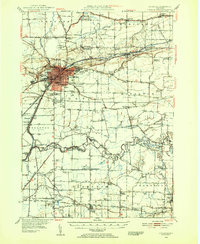
(176)- 1894 Map of Niagara Falls
 1894 Niagara Falls1894 Print · USGSThe Niagara frontier in the early 1890s shows a landscape of strategic forts and burgeoning rail power. Trace the international border from Fort Niagara past the Brock Monument to the rail hubs at Suspension Bridge.
 - 1894 Map of Wilson
 1894 Wilson1894 Print · USGSNiagara County's lakefront comes alive in the late nineteenth century as a thriving coastal and rail corridor. Genealogists can trace family lands near Wilson, North Wilson, and the Rome Watertown and Ogdensburg Station.2 unique versions available
 - 1896 Map of Niagara Falls
 1896 Niagara Falls1896 Print · USGSThe Niagara frontier at the close of the nineteenth century was a landscape of international boundaries and massive engineering. Trace the complex rail networks through Suspension Bridge or the historic fortifications at Fort Niagara and Fort Massassauga.2 unique versions available
 - 1897 Map of Tonawanda
 1897 Tonawanda1897 Print · USGSNiagara and Erie counties thrived at the close of the nineteenth century as vital corridors of commerce. Genealogists and historians can trace the early rail networks through Pekin or locate riverside landmarks like Sour Spring Grove and the Erie Canal.
 - 1897 Map of Olcott
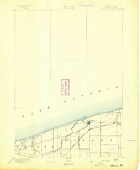
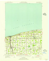
 1897 Olcott1897 Print · USGSNiagara County's lakefront and agricultural interior are captured here in the late 1890s as the rail era reached its peak. Genealogists can trace family lands near Newfane or locate early infrastructure like the Olcott L.H. and the Rome Watertown and Ogdensburg R.R. line.6 unique versions available
 - 1897 Map of Medina
 1897 Medina1897 Print · USGSWestern New York at the close of the nineteenth century reveals a landscape defined by the Erie Canal and the Tonawanda Indian Reservation. Researchers can trace the early rail-and-water economy through settlements like Medina, Akron, and the vanished stops of Smithville Sta.7 unique versions available
 - 1897 Map of Lockport
 1897 Lockport1897 Print · USGSNiagara County was a powerhouse of canal and rail commerce during the 1890s, centered on the engineering marvels at Lockport. Genealogists and historians can trace the early foundations of Clarence Center, locate Swifts Mills, or follow the original path of the Erie Canal past Raynales Basin.
 - 1897 Map of Ridgeway
 1897 Ridgeway1897 Print · USGSOrleans and Niagara Counties are captured here in the late 1890s, where the bustling ERIE CANAL and the Rome Watertown and Ogdensburg R. R. define the local economy. Genealogists and historians can trace family-named sites along the Ridge Road and locate long-standing hamlets like Lyndonville and Kuckville.5 unique versions available
 - 1899 Map of Niagara
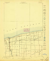
 1899 Niagara1899 Print · USGSThe Niagara Frontier is mapped here in the late nineteenth century as a bustling corridor of trade and transport. Researchers can trace the path of the Erie Canal through Lockport or locate early rural settlements like Ransomville and the Tuscarora Indian Reservation.6 unique versions available
 - 1900 Map of Wilson
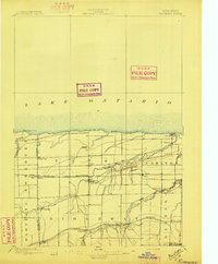
 1900 Wilson1900 Print · USGSNiagara County's shoreline at the turn of the century shows a landscape of established orchards and quiet lakefront ports. Genealogists can trace the early layout of Wilson and North Wilson or locate the Rome Watertown and Ogdensburg Station along the rail line.5 unique versions available
 - 1900 Map of Tonawanda
 1900 Tonawanda1900 Print · USGSNiagara County and northern Erie County are shown at the turn of the century as the Erie Canal and heavy rail lines drove the growth of the North Tonawanda lumber and shipping hub. Genealogists can trace family footprints in outlying hamlets like Bergholtz, Ransomville, and Martinsville.
 - 1900 Map of Niagara Falls, 1961 Print
 1900 Niagara Falls1961 Print · USGSThe Niagara frontier at the turn of the century shows an intense convergence of industrial power and military history along the international border. Trace the rail-and-river economy through the Suspension Bridge and Michigan Central R. R. or locate old landmarks like Fort Niagara and the Whirlpool.4 unique versions available
 - 1901 Map of Niagara Falls
 1901 Niagara Falls1901 Print · USGSThe Niagara frontier at the dawn of the twentieth century is captured here in striking detail, from the river's mouth to the falls. Trace the dense rail networks of the Niagara Falls area or locate Fort Niagara and the Brock Monument.11 unique versions available
 - 1901 Map of Tonawanda
 1901 Tonawanda1901 Print · USGSAt the turn of the century, the Niagara Frontier was a powerhouse of canal and rail transit. Genealogists can trace family footprints in settlements like Sanborn, Martinsville, and Bergholtz, or follow the original path of the ERIE CANAL through Tonawanda.7 unique versions available
 - 1902 Map of Lockport
 1902 Lockport1902 Print · USGSNiagara and Erie Counties thrived at the turn of the century as the Erie Canal and heavy rail transformed the region. Researchers can trace ancestral property near Lockport or locate vanished stops along the Batavia and Tonawanda Shore Line and near Reynales Basin.6 unique versions available
 - 1905 Map of Lockport, 1906 Print
 1905 Lockport1906 Print · USGSNiagara and Erie counties at the height of the canal and rail era show a landscape defined by the Erie Canal. Trace family roots in Lockport or explore early transit networks through Transit Sta., Akron, and the Electric R. R.
 - 1948 Map of Tonawanda, 1953 Print
 1948 Tonawanda1953 Print · USGSNiagara and Erie counties are shown here just after the war, where the Niagara River meets the historic Erie Canal. Genealogists and local historians can trace the early layout of North Tonawanda or locate family sites at Molyneaux Corners and Colonial Village.3 unique versions available
 - 1948 Map of Lockport, 1953 Print
 1948 Lockport1953 Print · USGSNiagara and Erie Counties are shown here during the late forties, when the canal and rail lines still anchored the regional economy. Researchers can locate numerous numbered rural schoolhouses and vanished stops like Hodgeville Sta or Akron Junction.3 unique versions available
 - 1948 Map of Wilson, 1956 Print
 1948 Wilson1956 Print · USGSNiagara County's Lake Ontario shoreline comes alive in the late 1940s, showcasing a network of summer beach colonies and inland farming hamlets. Trace family roots at Greenwood Cem, locate the old School No 8, or follow the New York Central tracks through Wilson.2 unique versions available
 - 1948 Map of Olcott, 1956 Print
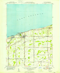
 1948 Olcott1956 Print · USGSNiagara County's lakefront and orchard country are captured here in the late 1940s as industry and agriculture moved by rail. Trace the New York Central line through Newfane or locate family roots at St Johns Ch, Corwin Cem, and various numbered schoolhouses.
 - 1948 Map of Tonawanda West, 1958 Print
 1948 Tonawanda West1958 Print · USGSThe industrial and riverfront character of the Niagara frontier is on full display during the postwar era. Genealogists and historians can trace rail networks like the New York Central RR and locate local landmarks such as Bishop Duffy High Sch or the Holy Ghost Cem (Church).2 unique versions available
 - 1949 Map of Wilson
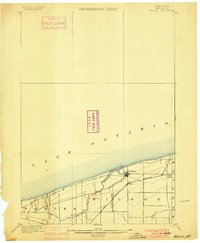
 1949 Wilson1949 Print · USGSThe Niagara County shoreline was a mix of quiet summer colonies and agricultural hamlets in the years following the war. Researchers can trace family roots through landmarks like Tuscarora Cem, St Peters Ch, and the rail stops along the New York Central.
 - 1949 Map of Cambria
 1949 Cambria1949 Print · USGSNiagara County's rural landscape is captured here in the late 1940s, highlighting the dramatic transition of the escarpment and the rail-fed agriculture of the era. Genealogists and historians can trace several named crossroads and early district schools, from Molyneaux Corners to School No 9 and the historic St Andrews Sch.
 - 1949 Map of Barker
 1949 Barker1949 Print · USGSNiagara County's Lake Ontario shoreline in the late 1940s is defined by productive orchards and small rail-centered villages. Genealogists and historians can trace the foundations of local life through landmarks like Quaker Road Ch, the Trade School Airport, and School No 11.
 - 1949 Map of Sixmile Creek
 1949 Sixmile Creek1949 Print · USGSThe Lake Ontario shoreline in Niagara County remained a mix of quiet fruit orchards and summer beaches in the years following World War II. Genealogists and local historians can trace the rural landscape through Filmore Chapel Cem, family-named tracts like Harrison Grove, and old routes like Braley Road.
Showing maps 1-25 of 176
Top cities of Niagara County
- Niagara Falls historical maps
- North Tonawanda historical maps
- Lockport historical maps
- Lockport historical maps
- Wheatfield historical maps
- Lewiston historical maps
See more
Frequently asked questions
- What are the different types of historical maps available for Niagara County?
- What is the oldest map of Niagara County?
- Where can I purchase historical maps of Niagara County for my home or office?
- Where can I download high-res historical maps of Niagara County?
- Are there historical topographic maps available for Niagara County?
- Is there historical aerial imagery available for Niagara County?
- Where are historical maps of Niagara County sourced from?