1980s Maps of Williams County, North Dakota
Explore 7 historic maps of Williams County from the 1980s. These maps offer a rare glimpse into what life looked like during the 1980s — showing old roads, neighborhoods, homes, and landmarks that have changed or disappeared over time.
Whether you're researching your family's past, planning a metal detecting trip, or studying how Williams County's landscape evolved across the 1980s, these high-resolution maps are a powerful tool for exploring the history of this region.
- Focus on a specific era: All maps on this page are from the 1980s, giving you a focused view of this time period.
- See what’s changed: Compare century-old streets, trails, and buildings to today's modern landscape using overlays and satellite layers.
- Research with precision: Use these maps for genealogy, historical research, land use analysis, or educational projects.
- View, download, or print: Maps are fully viewable online in high resolution, and can be downloaded or printed for your own records.
Start exploring Williams County's history through authentic maps from the 1980s. This is your window into the past.
Williams County, ND maps
(7)- 1981 Map of Sidney
 1981 Sidney1981 Print · USGSThe Montana-North Dakota borderlands appear in the early 1980s, centered on the river-fed agricultural hub of Sidney. Researchers can trace the Burlington Northern rail lines and the rural layouts of Fairview, Lambert, and Enid.
 - 1982 Map of Kenmare
 1982 Kenmare1982 Print · USGSThe high plains of northwestern North Dakota meet the Canadian border in the early 1980s, an era defined by energy production and prairie conservation. Genealogists and historians can trace the rail corridors of the Soo Line through towns like Bowbells, Flaxton, and the border crossing at Portal.
 - 1982 Map of Culbertson, 1983 Print
 1982 Culbertson1983 Print · USGSNortheastern Montana at the start of the 1980s reveals a high-plains landscape defined by the Missouri River and the rail lines that served its valley. Genealogists and researchers can trace the townships surrounding Culbertson, Bainville, and the Fort Union Trading Post.
 - 1983 Map of Writing Rock South, 1984 Print
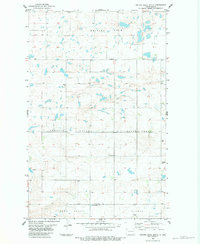 1983 Writing Rock South1984 Print · USGSThe high plains of the Divide and Williams County line come into focus during the early eighties, showcasing a landscape of section-line roads and prairie townships. Genealogists and local historians can trace family ties at Bethany Ch and the Cem, or follow the path of the Sioux Trail through Fertile Valley.
 - 1983 Map of Williston, 1984 Print
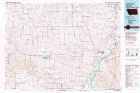
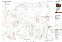
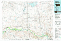
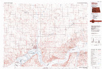 1983 Williston1984 Print · USGSWilliston and the Missouri River basin are captured here in the early eighties as the regional landscape transitioned into a modern energy and agricultural hub. Researchers can trace the Burlington Northern line through prairie towns like Epping and Wheelock, or explore the riparian geography of Lake Sakakawea.
 - 1983 Map of Dominek Lake, 1984 Print
 1983 Dominek Lake1984 Print · USGSThe Montana-North Dakota borderlands are captured here in the early eighties, showcasing a region of prairie lakes and rising energy production. Researchers can locate Immanuel Cem and trace rural infrastructure like the Drill Hole and Oil Wells near Dominek Lake.
 - 1984 Map of Crosby
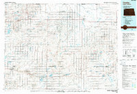 1984 Crosby1984 Print · USGSNorthwestern North Dakota during the mid-1980s shows a landscape of prairie wetlands and railroad towns near the Canadian border. Researchers can trace the Old Bounty Railroad Grade or locate the Fortuna Air Force Station alongside family-named landmarks like Piepers Lake and Tom Berg Lake.2 unique versions available
End of results
Showing maps 1-7 of 7
Top cities of Williams County
- Williston historical maps
- Tioga historical maps
- Trenton historical maps
- Ray historical maps
- Grenora historical maps
- Buford historical maps
See more
Frequently asked questions
- What are the different types of historical maps available for Williams County?
- What is the oldest map of Williams County?
- Where can I purchase historical maps of Williams County for my home or office?
- Where can I download high-res historical maps of Williams County?
- Are there historical topographic maps available for Williams County?
- Is there historical aerial imagery available for Williams County?
- Where are historical maps of Williams County sourced from?