1990s Maps of Williams County, North Dakota
Explore 3 historic maps of Williams County from the 1990s. These maps offer a rare glimpse into what life looked like during the 1990s — showing old roads, neighborhoods, homes, and landmarks that have changed or disappeared over time.
Whether you're researching your family's past, planning a metal detecting trip, or studying how Williams County's landscape evolved across the 1990s, these high-resolution maps are a powerful tool for exploring the history of this region.
- Focus on a specific era: All maps on this page are from the 1990s, giving you a focused view of this time period.
- See what’s changed: Compare century-old streets, trails, and buildings to today's modern landscape using overlays and satellite layers.
- Research with precision: Use these maps for genealogy, historical research, land use analysis, or educational projects.
- View, download, or print: Maps are fully viewable online in high resolution, and can be downloaded or printed for your own records.
Start exploring Williams County's history through authentic maps from the 1990s. This is your window into the past.
Williams County, ND maps
(3)- 1997 Map of Red Mike Hill, 2001 Print
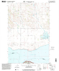 1997 Red Mike Hill2001 Print · USGSWestern North Dakota prairie meets the expanse of the Missouri in the late nineties, documenting the rural landscape of Williams and McKenzie counties. Genealogists and historians can locate Beaver Creek Ch, Hofflund Sch, and industrial sites like the Scoria Pits.
 - 1997 Map of Charlson SW, 2001 Print
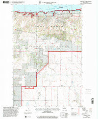 1997 Charlson SW2001 Print · USGSThe high plains of McKenzie County meet the waters of the Missouri in the late 1990s. Researchers can trace the industrial landscape of the Charlson Oil Field alongside local landmarks like Good Hope Ch and Lone Butte.
 - 1997 Map of Banks, 2001 Print
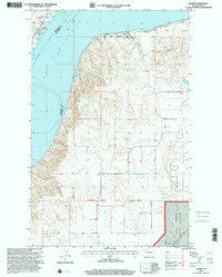 1997 Banks2001 Print · USGSMcKenzie County's high-prairie landscape is captured here in the late nineties, documenting the rugged breaks where Twin Valley meets Lake Sakakawea. Researchers can locate the Garden Valley Cem, the small settlement of Banks, and family-named landmarks like the J Grantier Ranch.
End of results
Showing maps 1-3 of 3
Top cities of Williams County
- Williston historical maps
- Tioga historical maps
- Trenton historical maps
- Ray historical maps
- Grenora historical maps
- Buford historical maps
See more
Frequently asked questions
- What are the different types of historical maps available for Williams County?
- What is the oldest map of Williams County?
- Where can I purchase historical maps of Williams County for my home or office?
- Where can I download high-res historical maps of Williams County?
- Are there historical topographic maps available for Williams County?
- Is there historical aerial imagery available for Williams County?
- Where are historical maps of Williams County sourced from?