1920s Maps of Lane County, Oregon
Explore 9 historic maps of Lane County from the 1920s. These maps offer a rare glimpse into what life looked like during the 1920s — showing old roads, neighborhoods, homes, and landmarks that have changed or disappeared over time.
Whether you're researching your family's past, planning a metal detecting trip, or studying how Lane County's landscape evolved across the 1920s, these high-resolution maps are a powerful tool for exploring the history of this region.
- Focus on a specific era: All maps on this page are from the 1920s, giving you a focused view of this time period.
- See what’s changed: Compare century-old streets, trails, and buildings to today's modern landscape using overlays and satellite layers.
- Research with precision: Use these maps for genealogy, historical research, land use analysis, or educational projects.
- View, download, or print: Maps are fully viewable online in high resolution, and can be downloaded or printed for your own records.
Start exploring Lane County's history through authentic maps from the 1920s. This is your window into the past.
Lane County, OR maps
(9)- 1920 Map of Siltcoos Lake
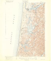 1920 Siltcoos Lake1920 Print · USGSThe Oregon coast at the end of the Great War reveals a landscape of river inlets and timber-driven rail lines. You can trace the Southern Pacific tracks past rural schoolhouses like Idlewild School and old stops at Cushman P.O. or Acme.3 unique versions available
 - 1920 Map of Heceta Head
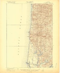 1920 Heceta Head1920 Print · USGSThe Oregon coast at the end of the First World War shows a rugged landscape of isolated schoolhouses and coastal outposts. Genealogists and historians can locate early landmarks like the Coast Guard Station, Mercer School, and the historic trail at The Portage.4 unique versions available
 - 1921 Map of Brownsville
 1921 Brownsville1921 Print · USGSLinn County agriculture and early rail travel define this landscape in the years following the Great War. Genealogists can trace the rural communities surrounding Brownsville through the locations of the Union Point School, Diamond Hill School, and the Southern Pacific line.4 unique versions available
 - 1921 Map of Cottage Grove
 1921 Cottage Grove1921 Print · USGSSouthern Lane County comes alive in this post-World War I survey, showing the valley floor before modern development. Genealogists can locate family homesteads near old schoolhouses like Green Door School or trace the early rail stops at Saginaw and Latham.3 unique versions available
 - 1922 Map of Monroe
 1922 Monroe1922 Print · USGSThe Willamette Valley’s southern reaches come to life in this survey from the decade after the Great War, showing the early infrastructure of Benton and Lane counties. Genealogists can trace family footprints across dozens of country schools like Winkle School and lost rail stops along the Southern Pacific line.4 unique versions available
 - 1922 Map of Waldport
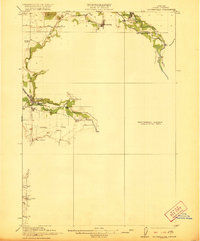
 1922 Waldport1922 Print · USGSCoastal Oregon at the end of the Great War era reveals a landscape of isolated bays and forest outposts. Genealogists and local historians can trace early settlements like Waldport and Sanlots, or locate the site of the rural Alder Grove School.2 unique versions available
 - 1922 Map of Elmira
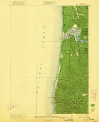
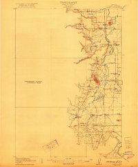 1922 Elmira1922 Print · USGSLane County's timber and rail landscape is caught in detail in the early 1920s, showcasing the development of rural communities and milling operations. Genealogists can locate family homesteads near numerous local institutions like Redonk School, Perkins Mill, and the many stations along the Oregon Electric line.3 unique versions available
 - 1925 Map of Waldo Lake
 1925 Waldo Lake1925 Print · USGSThe High Cascades near the Lane and Klamath county line are shown here in the mid-1920s as a frontier of forestry and high-country ranching. Trace early landmarks like the State Fish Hatchery, the High Prairie School, and the remote Hills Ranch.4 unique versions available
 - 1929 Map of Three Sisters, 1956 Print
 1929 Three Sisters1956 Print · USGSThe High Cascades meet the Deschutes plateau in the late 1920s, a time when fire lookouts and cow camps dotted the volcanic peaks. Genealogists and historians can trace the early footprints of Sisters, Camp Sherman, and the historic Old Toll Station.2 unique versions available
End of results
Showing maps 1-9 of 9
Top cities of Lane County
- Eugene historical maps
- Springfield historical maps
- Cottage Grove historical maps
- Florence historical maps
- Junction City historical maps
- Creswell historical maps
See more
Frequently asked questions
- What are the different types of historical maps available for Lane County?
- What is the oldest map of Lane County?
- Where can I purchase historical maps of Lane County for my home or office?
- Where can I download high-res historical maps of Lane County?
- Are there historical topographic maps available for Lane County?
- Is there historical aerial imagery available for Lane County?
- Where are historical maps of Lane County sourced from?