Old Maps of Lane County, Oregon for Academic Research
Study the evolution of Lane County with 764 high-resolution historic maps. Whether you're teaching, researching, or modeling changes in land use, these maps provide essential visual documentation of urban, environmental, and geographic change.
- Analyze long-term change: Track patterns in development, transportation, and natural features.
- Ideal for environmental or urban studies: Support academic projects with primary historical map data.
- Use in the classroom or lab: Educators and researchers rely on these maps to bring historical context to life.
These maps are a powerful tool for teaching, research, and visualizing how Lane County has changed over the decades.
Lane County, OR maps
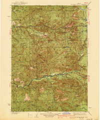
(764)- 1909 Map of Harrisburg
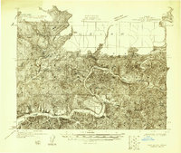
 1909 Harrisburg1909 Print · USGSThe Willamette Valley at the end of the first decade of the twentieth century shows a landscape tied to both river and rail. Researchers can trace the early road network like Halsey Road and locate numerous local landmarks like Ingrams Ferry or the Muddy School.
 - 1909 Map of Elmira
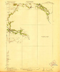
 1909 Elmira1909 Print · USGSLane County at the turn of the century shows a landscape of river-bottom farms and emerging rail towns. Genealogists and historians can locate early landmarks like Perkins Mill, the Redonk School, and the original footprints of Elmira and Alvadore.
 - 1910 Map of Eugene
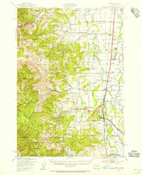
 1910 Eugene1910 Print · USGSThe upper Willamette Valley comes to life in the years before the Great War, centered on the growing campus of the University of Oregon. Genealogists can trace family footprints across dozens of local school districts like Santa Clara and Deadman, or follow the early tracks of the Oregon Electric RR.2 unique versions available
 - 1911 Map of Monroe
 1911 Monroe1911 Print · USGSThe Willamette Valley foothills meet the river bottomlands in the early twentieth century near the Benton and Lane county border. Genealogists and researchers can trace early settlements at Bellfountain and Alpine or locate rural landmarks like Irish Bend School and Ferguson Bridge.
 - 1912 Map of Halsey
 1912 Halsey1912 Print · USGSThe Willamette Valley’s fertile floor and expanding rail networks are documented here just before the era of modern highways. Local historians can locate numerous vanished rural landmarks, from the Ingram Ferry crossing to schoolhouses like Bell Plain School and Harris School.3 unique versions available
 - 1917 Map of Diamond Lake
 1917 Diamond Lake1917 Print · USGSThe high Cascades of Douglas and Klamath Counties are captured here just before the First World War. Local historians and hikers can trace early forest service outposts like Higdon Ranger Sta and remote routes including the Ft Klamath Road and Bradley Trail.3 unique versions available
 - 1918 Map of Mapleton
 1918 Mapleton1918 Print · USGSCoastal Oregon at the end of the Great War was defined by its timber operations and river-bound settlements. Researchers can trace the path of the Southern Pacific railroad as it winds past Swisshome and the Minerva PO.
 - 1919 Map of Earl
 1919 Earl1919 Print · USGSThe Oregon Coast Range in the years after the Great War shows a landscape of isolated homesteads and river-carved canyons. Researchers can trace early family sites like Fiske Ranch and Stokes Ranch or locate remote rural schoolhouses such as Sulphur Springs School.
 - 1920 Map of Siltcoos Lake
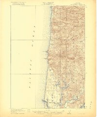
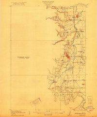
 1920 Siltcoos Lake1920 Print · USGSThe Oregon coast at the end of the Great War reveals a landscape of river inlets and timber-driven rail lines. You can trace the Southern Pacific tracks past rural schoolhouses like Idlewild School and old stops at Cushman P.O. or Acme.3 unique versions available
 - 1920 Map of Heceta Head
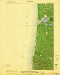
 1920 Heceta Head1920 Print · USGSThe Oregon coast at the end of the First World War shows a rugged landscape of isolated schoolhouses and coastal outposts. Genealogists and historians can locate early landmarks like the Coast Guard Station, Mercer School, and the historic trail at The Portage.4 unique versions available
 - 1921 Map of Brownsville
 1921 Brownsville1921 Print · USGSLinn County agriculture and early rail travel define this landscape in the years following the Great War. Genealogists can trace the rural communities surrounding Brownsville through the locations of the Union Point School, Diamond Hill School, and the Southern Pacific line.4 unique versions available
 - 1921 Map of Cottage Grove
 1921 Cottage Grove1921 Print · USGSSouthern Lane County comes alive in this post-World War I survey, showing the valley floor before modern development. Genealogists can locate family homesteads near old schoolhouses like Green Door School or trace the early rail stops at Saginaw and Latham.3 unique versions available
 - 1922 Map of Monroe
 1922 Monroe1922 Print · USGSThe Willamette Valley’s southern reaches come to life in this survey from the decade after the Great War, showing the early infrastructure of Benton and Lane counties. Genealogists can trace family footprints across dozens of country schools like Winkle School and lost rail stops along the Southern Pacific line.4 unique versions available
 - 1922 Map of Waldport
 1922 Waldport1922 Print · USGSCoastal Oregon at the end of the Great War era reveals a landscape of isolated bays and forest outposts. Genealogists and local historians can trace early settlements like Waldport and Sanlots, or locate the site of the rural Alder Grove School.2 unique versions available
 - 1922 Map of Elmira
 1922 Elmira1922 Print · USGSLane County's timber and rail landscape is caught in detail in the early 1920s, showcasing the development of rural communities and milling operations. Genealogists can locate family homesteads near numerous local institutions like Redonk School, Perkins Mill, and the many stations along the Oregon Electric line.3 unique versions available
 - 1925 Map of Waldo Lake
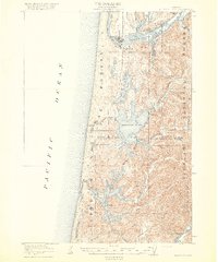
 1925 Waldo Lake1925 Print · USGSThe High Cascades near the Lane and Klamath county line are shown here in the mid-1920s as a frontier of forestry and high-country ranching. Trace early landmarks like the State Fish Hatchery, the High Prairie School, and the remote Hills Ranch.4 unique versions available
 - 1929 Map of Three Sisters, 1956 Print
 1929 Three Sisters1956 Print · USGSThe High Cascades meet the Deschutes plateau in the late 1920s, a time when fire lookouts and cow camps dotted the volcanic peaks. Genealogists and historians can trace the early footprints of Sisters, Camp Sherman, and the historic Old Toll Station.2 unique versions available
 - 1930 Map of Maiden Peak
 1930 Maiden Peak1930 Print · USGSThe high volcanic plateau of central Oregon is captured in the early 1930s as a landscape of new reservoirs and forest outposts. Genealogists and historians can trace family-named sites like Caldwell Ranch or follow early travel routes like Century Drive and the Southern Pacific rail line.3 unique versions available
 - 1932 Map of Three Sisters
 1932 Three Sisters1932 Print · USGSThe eastern Cascades and the high desert meet in the early 1930s as the regional highway system begins to pierce the mountains. Genealogists and historians can trace early settlements like Camp Polk and Sisters or locate old forest landmarks such as Camp Sherman and Black Butte.3 unique versions available
 - 1934 Map of Maiden Peak
 1934 Maiden Peak1934 Print · USGSCentral Oregon’s high desert and timberlands are captured here in the early thirties, centered on the Crane Prairie Reservoir. Researchers can find isolated outposts like Caldwell Ranch, the Log Cabin, and Lapine at the highway junction.3 unique versions available
 - 1934 Map of Mc Kenzie Bridge
 1934 Mc Kenzie Bridge1934 Print · USGSThe Cascades in the mid-1930s were a network of forest guard stations, remote ranches, and early mountain resorts. Genealogists and historians can locate family landmarks such as Sims Ranch and Hardy Cabin or trace the early developments at Belknap Springs.
 - 1935 Map of Lowell
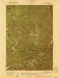
 1935 Lowell1935 Print · USGSIn the mid-1930s, this region of the Willamette foothills was a busy landscape of timber and rail. Researchers can trace rural school districts like Unity Sch, small post offices at Fall Creek PO, and the path of the Southern Pacific railroad.
 - 1939 Map of Monroe, 1956 Print
 1939 Monroe1956 Print · USGSBenton County agriculture and timber meet at the foot of the Coast Range in the late thirties. Genealogists can trace family footprints through the numerous rural school districts, including Beaver Creek Sch, or locate old rail stops at Alpine Junction and Burnett.
 - 1940 Map of Mapleton
 1940 Mapleton1940 Print · USGSCoastal Oregon at the dawn of the 1940s reveals a river-driven economy of small schools and railroad stops. Genealogists can trace family landmarks like Lowney Ranch, identify rural schoolhouse locations including Minerva Sch, or follow the Southern Pacific line through Swisshome.
 - 1940 Map of Mc Kenzie Bridge
 1940 Mc Kenzie Bridge1940 Print · USGSThe Oregon Cascades during the late 1930s reveal a landscape of mining claims and early forest service outposts. Trace the locations of historic mineral sites like the Lucky Boy Mine, family homesteads at Cooks Ranch, and mountain retreats at Belknap Springs.3 unique versions available
Showing maps 1-25 of 764
Top cities of Lane County
- Eugene historical maps
- Springfield historical maps
- Cottage Grove historical maps
- Florence historical maps
- Junction City historical maps
- Creswell historical maps
See more
Frequently asked questions
- What are the different types of historical maps available for Lane County?
- What is the oldest map of Lane County?
- Where can I purchase historical maps of Lane County for my home or office?
- Where can I download high-res historical maps of Lane County?
- Are there historical topographic maps available for Lane County?
- Is there historical aerial imagery available for Lane County?
- Where are historical maps of Lane County sourced from?