1970s Maps of Lane County, Oregon
Explore 7 historic maps of Lane County from the 1970s. These maps offer a rare glimpse into what life looked like during the 1970s — showing old roads, neighborhoods, homes, and landmarks that have changed or disappeared over time.
Whether you're researching your family's past, planning a metal detecting trip, or studying how Lane County's landscape evolved across the 1970s, these high-resolution maps are a powerful tool for exploring the history of this region.
- Focus on a specific era: All maps on this page are from the 1970s, giving you a focused view of this time period.
- See what’s changed: Compare century-old streets, trails, and buildings to today's modern landscape using overlays and satellite layers.
- Research with precision: Use these maps for genealogy, historical research, land use analysis, or educational projects.
- View, download, or print: Maps are fully viewable online in high resolution, and can be downloaded or printed for your own records.
Start exploring Lane County's history through authentic maps from the 1970s. This is your window into the past.
Lane County, OR maps
(7)- 1970 Map of Crescent, 1973 Print
 1970 Crescent1973 Print · USGSCentral Oregon in the early seventies reveals a landscape of volcanic peaks and timber outposts connected by the Southern Pacific rail line. Researchers can trace the layout of Christmas Valley, locate Cabin Lake Ranger Station, and explore the geological footprint of Newberry Crater.
 - 1975 Map of Elmira SE, 1979 Print
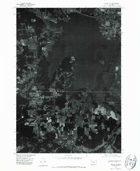 1975 Elmira SE1979 Print · USGSLane County's landscape comes into sharp focus in the mid-1970s, showcasing the expansion of local communities and the wide reach of the reservoir. Trace the growth of VENETA and ELMIRA alongside the intricate shoreline of Fern Ridge Reservoir.
 - 1975 Map of Eugene East, 1979 Print
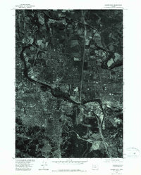 1975 Eugene East1979 Print · USGSMid-seventies Lane County comes into focus in this detailed orthophoto showing the urban development of the upper Willamette Valley. Genealogists and local historians can trace the 1970s footprints of Eugene and Springfield along the Willamette River.
 - 1975 Map of Eugene West, 1980 Print
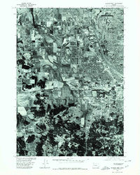 1975 Eugene West1980 Print · USGSWestern Lane County is shown mid-growth in the 1970s as urban sprawl begins to meet the valley's agricultural roots. Researchers can trace the layout of Eugene and Santa Clara or study the elevation near Murray Hill.
 - 1976 Map of Springfield, 1979 Print
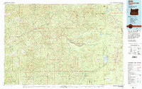
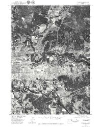 1976 Springfield1979 Print · USGSSpringfield and its riverfront were entering a period of significant growth in the mid-seventies. Trace the shifting banks of the Mc Kenzie River and the winding Coast Fork Willamette River as they frame the city's expanding footprint.
 - 1978 Map of Diamond Lake, 1994 Print
 1978 Diamond Lake1994 Print · USGSThe Cascades of the late 1970s are seen here at a point of high-mountain industry and recreation across the Umpqua and Willamette forests. Researchers can trace the development of timber and water resources around Toketee Falls, Umpqua Mine, and Steamboat.2 unique versions available
 - 1979 Map of Cottage Grove
 1979 Cottage Grove1979 Print · USGSThe Oregon timber and rail corridors of the late seventies are documented here, centered on the Coast Fork Willamette River and the growing hub of Cottage Grove. Researchers can trace the path of the Southern Pacific railroad as it connects small stations like Divide, Saginaw, and Yoncalla.2 unique versions available
End of results
Showing maps 1-7 of 7
Top cities of Lane County
- Eugene historical maps
- Springfield historical maps
- Cottage Grove historical maps
- Florence historical maps
- Junction City historical maps
- Creswell historical maps
See more
Frequently asked questions
- What are the different types of historical maps available for Lane County?
- What is the oldest map of Lane County?
- Where can I purchase historical maps of Lane County for my home or office?
- Where can I download high-res historical maps of Lane County?
- Are there historical topographic maps available for Lane County?
- Is there historical aerial imagery available for Lane County?
- Where are historical maps of Lane County sourced from?