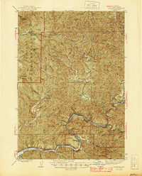
1940s Maps of Lane County, Oregon
Explore 23 historic maps of Lane County from the 1940s. These maps offer a rare glimpse into what life looked like during the 1940s — showing old roads, neighborhoods, homes, and landmarks that have changed or disappeared over time.
Whether you're researching your family's past, planning a metal detecting trip, or studying how Lane County's landscape evolved across the 1940s, these high-resolution maps are a powerful tool for exploring the history of this region.
- Focus on a specific era: All maps on this page are from the 1940s, giving you a focused view of this time period.
- See what’s changed: Compare century-old streets, trails, and buildings to today's modern landscape using overlays and satellite layers.
- Research with precision: Use these maps for genealogy, historical research, land use analysis, or educational projects.
- View, download, or print: Maps are fully viewable online in high resolution, and can be downloaded or printed for your own records.
Start exploring Lane County's history through authentic maps from the 1940s. This is your window into the past.
Lane County, OR maps
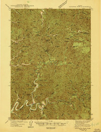
(23)- 1940 Map of Mapleton
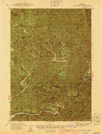 1940 Mapleton1940 Print · USGSCoastal Oregon at the dawn of the 1940s reveals a river-driven economy of small schools and railroad stops. Genealogists can trace family landmarks like Lowney Ranch, identify rural schoolhouse locations including Minerva Sch, or follow the Southern Pacific line through Swisshome.
 - 1940 Map of Mc Kenzie Bridge
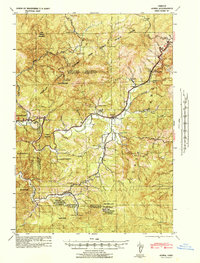
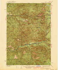 1940 Mc Kenzie Bridge1940 Print · USGSThe Oregon Cascades during the late 1930s reveal a landscape of mining claims and early forest service outposts. Trace the locations of historic mineral sites like the Lucky Boy Mine, family homesteads at Cooks Ranch, and mountain retreats at Belknap Springs.3 unique versions available
 - 1940 Map of Eugene
 1940 Eugene1940 Print · USGSThe Willamette Valley at the end of the Great Depression shows a landscape of growing towns and busy rail corridors. Genealogists can locate family-named landmarks like Gillespie Butte School and the I O O F Cemetery.2 unique versions available
 - 1941 Map of Blachly
 1941 Blachly1941 Print · USGSCoastal Oregon timber country comes into focus in the early 1940s, highlighting a landscape of remote sawmills and early forest management. Trace the legacy of the local lumber industry through the Logging Flume (Abandoned), the Triangle Lumber Co, and the Southern Pacific rail line.
 - 1941 Map of Halsey
 1941 Halsey1941 Print · USGSLinn County agriculture and river commerce are on full display during the early 1940s as rail and ferry networks connected the Willamette valley. Genealogists can locate family landmarks like Bell Plain School, the Irish Bend Ferry, and the Pine Grove Church.
 - 1941 Map of Siltcoos Lake, 1958 Print
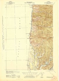
 1941 Siltcoos Lake1958 Print · USGSThe Oregon coast at the onset of World War II was a landscape of timber, dunes, and vital freshwater lakes. Researchers can trace the early path of the Oregon Coast Highway past Idlewilde Sch and through settlements like Westlake and Cushman.
 - 1942 Map of Alsea
 1942 Alsea1942 Print · USGSBenton and Lincoln Counties are shown in great detail during the early 1940s, highlighting the intersection of the timber industry and rural settlement. Researchers can locate remote sites like Missouri Bend Sch, the Alsea Lumber Co, and early mountain lookouts including West Tree Lookout.
 - 1942 Map of Lowell
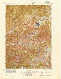
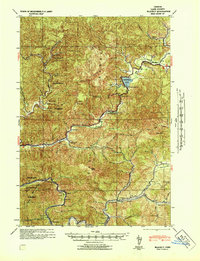
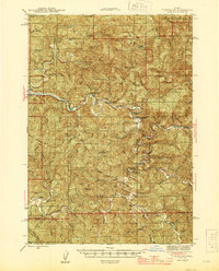
 1942 Lowell1942 Print · USGSThe Willamette River valley and the foothills of the Cascades are captured here before the construction of major dams and reservoirs. Genealogists can trace family locations at the Smithson Homestead, early schools like Unity Sch, and the remote Bohemia Post Office.3 unique versions available
 - 1942 Map of Elmira
 1942 Elmira1942 Print · USGSThe rural valleys and timbered foothills of western Lane County are captured in detail just as the second World War began. Genealogists and historians can trace family locations through numerous named schools like Laurel Home Sch and settlements along the Southern Pacific tracks.
 - 1942 Map of Blachly
 1942 Blachly1942 Print · USGSThe Oregon Coast Range in the early 1940s reveals a landscape of isolated ranches and timber camps connected by the Siuslaw River. Genealogists and historians can trace family properties like Haywire Ranch and Bessonette Ranch or locate the Triangle Lake CCC Camp and the Lyons Sch.
 - 1942 Map of Waldport
 1942 Waldport1942 Print · USGSThe Oregon coast at the onset of World War II reveals a landscape of isolated seaside settlements and managed forests. Trace the early layout of Waldport and Yachats alongside landmarks like the CCC Camp and Smithy Ranch.2 unique versions available
 - 1942 Map of Monroe
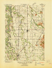
 1942 Monroe1942 Print · USGSBenton and Lane counties are shown just as the nation entered the war, featuring the river-and-rail corridor of the Long Tom River. Researchers can trace the rural landscape of schoolhouses and cemeteries like Oak Ridge Sch and Oak Ridge Cem.
 - 1942 Map of Heceta Head
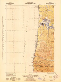
 1942 Heceta Head1942 Print · USGSThe Oregon coast in the early 1940s reveals a landscape of isolated forest farms and vital maritime outposts. Researchers can locate long-standing rural landmarks like Big Creek Sch, the Coast Guard Station, and Clover Ridge Farm.2 unique versions available
 - 1942 Map of Siltcoos Lake
 1942 Siltcoos Lake1942 Print · USGSCoastal Lane County at the start of the 1940s reveals a landscape of massive freshwater lakes and timber-rich national forest. Genealogists and historians can trace the rail stops at Cushman and Ada Sta or locate family landmarks near Siltcoos Lake and the Siuslaw River.
 - 1942 Map of Tidewater, 1945 Print
 1942 Tidewater1945 Print · USGSCoastal Oregon's winding river valleys are captured here during the mid-forties, showing the deep integration of the timber and fishing industries. You can locate early forest landmarks like Fivemile Shelter, the Upper Yachats Sch, and the State Fish Hatchery along the Alsea River.
 - 1942 Map of Crow, 1960 Print
 1942 Crow1960 Print · USGSLane and Douglas counties appear here during the early war years, showing a landscape shaped by timber management and remote ranching. Genealogists can locate family landmarks like Gillespie Corners, Hadleyville Sch, and the South Fork Guard Sta.2 unique versions available
 - 1942 Map of Roman Nose Mtn, 1962 Print
 1942 Roman Nose Mtn1962 Print · USGSThe Oregon Coast Range during the early 1940s is revealed here as a landscape of isolated homesteads and river-carved valleys. Researchers can locate remote schools like Alma Sch, the Southern Pacific rail line, and family landmarks including Hess Ranch and Luce Place.2 unique versions available
 - 1943 Map of Goodwin Peak
 1943 Goodwin Peak1943 Print · USGSCoastal range wilderness and isolated homesteads define this mid-century survey of the Lane and Douglas County line. Genealogists and researchers can locate family-named sites like Townsend Ranch, the North Fork Sch, and landmarks such as Smith River Falls.3 unique versions available
 - 1945 Map of Crow
 1945 Crow1945 Print · USGSThe rural borderlands of Lane and Douglas Counties appear here at the height of the mid-century timber era. Genealogists and historians can trace family-named landmarks and remote outposts such as Gillespie Corners, Hadleyville Sch, and the Wolf Creek Store.
 - 1945 Map of Mapleton
 1945 Mapleton1945 Print · USGSCoastal Oregon at the close of World War II was a landscape of river-oriented timber and ranching settlements. Researchers can trace the Southern Pacific rail line through Swisshome and Mapleton or locate rural schools like Minerva Sch.2 unique versions available
 - 1945 Map of Roman Nose Mtn
 1945 Roman Nose Mtn1945 Print · USGSCoastal Oregon's winding river valleys and timberlands are captured here during the mid-1940s, showing a remote landscape of forest guard stations and isolated homesteads. Researchers can locate family-named landmarks like Luce Place and Hess Ranch, or trace the Southern Pacific line through Linslaw.2 unique versions available
 - 1946 Map of Eugene, 1957 Print
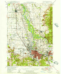 1946 Eugene1957 Print · USGSThe Willamette Valley was a bustling corridor of rail and river commerce just after the war. Researchers can trace the development of Eugene and Springfield, locate family landmarks like the I O O F Cemetery, and follow the path of the Oregon Electric Railroad.2 unique versions available
 - 1949 Map of Eugene
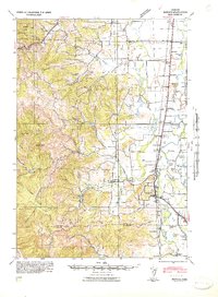
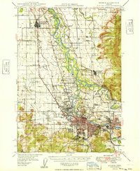 1949 Eugene1949 Print · USGSThe southern Willamette Valley thrived at mid-century as a rail and aviation hub connecting Junction City and Springfield. Researchers can trace old property lines through local landmarks like Lone Pine Sch and the I O O F Cemetery.
End of results
Showing maps 1-23 of 23
Top cities of Lane County
- Eugene historical maps
- Springfield historical maps
- Cottage Grove historical maps
- Florence historical maps
- Junction City historical maps
- Creswell historical maps
See more
Frequently asked questions
- What are the different types of historical maps available for Lane County?
- What is the oldest map of Lane County?
- Where can I purchase historical maps of Lane County for my home or office?
- Where can I download high-res historical maps of Lane County?
- Are there historical topographic maps available for Lane County?
- Is there historical aerial imagery available for Lane County?
- Where are historical maps of Lane County sourced from?