1950s Maps of Lane County, Oregon
Explore 48 historic maps of Lane County from the 1950s. These maps offer a rare glimpse into what life looked like during the 1950s — showing old roads, neighborhoods, homes, and landmarks that have changed or disappeared over time.
Whether you're researching your family's past, planning a metal detecting trip, or studying how Lane County's landscape evolved across the 1950s, these high-resolution maps are a powerful tool for exploring the history of this region.
- Focus on a specific era: All maps on this page are from the 1950s, giving you a focused view of this time period.
- See what’s changed: Compare century-old streets, trails, and buildings to today's modern landscape using overlays and satellite layers.
- Research with precision: Use these maps for genealogy, historical research, land use analysis, or educational projects.
- View, download, or print: Maps are fully viewable online in high resolution, and can be downloaded or printed for your own records.
Start exploring Lane County's history through authentic maps from the 1950s. This is your window into the past.
Lane County, OR maps
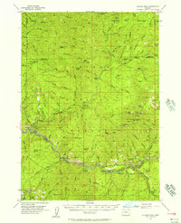
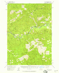
(48)- 1950 Map of Marcola, 1955 Print
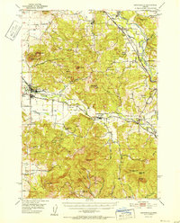
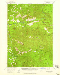
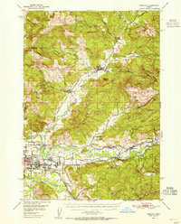 1950 Marcola1955 Print · USGSLane County in the early fifties shows a transition from timber-town economies to suburban growth near the McKenzie River. Researchers can locate family landmarks like the Camp Creek Cemetery, the Mohawk PO, and the rails of the Southern Pacific.2 unique versions available
 - 1950 Map of Brownsville, 1960 Print
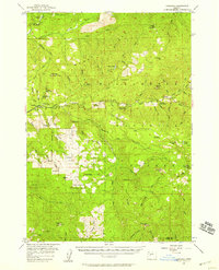
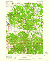 1950 Brownsville1960 Print · USGSLinn County agriculture and timber meet in the mid-1950s along the Calapooya River and South Santiam River. Genealogists and historians can trace the Oregon Electric line and locate sites like Union Point, Liberty Cem, and the Covered Bridge.3 unique versions available
 - 1951 Map of Sweet Home, 1952 Print
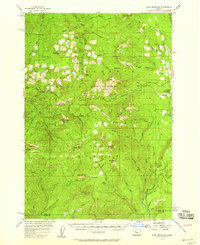
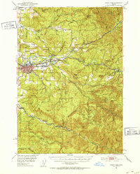 1951 Sweet Home1952 Print · USGSLinn County’s timber and river corridors come alive in this early fifties survey of the Santiam valley. Genealogists and local historians can trace the Oregon Electric line and find old landmarks like the Berlin Cem, Sunnyside School, and the Hufford Bridge.4 unique versions available
 - 1951 Map of Leaburg, 1952 Print
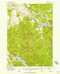
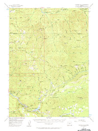
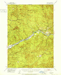 1951 Leaburg1952 Print · USGSThe McKenzie River corridor in the early fifties shows a landscape of hydroelectric progress and small riverside settlements. Genealogists and local historians can trace the foundations of Leaburg, Vida, and Deerhorn, or locate industrial landmarks like the Leaburg Power Plant and Leaburg Dam.4 unique versions available
 - 1952 Map of Brownsville
 1952 Brownsville1952 Print · USGSLinn County agriculture and timber industry are at a peak in the early fifties as the river valleys transition into the Cascade foothills. Researchers can trace family sites at Klum Cemetery, rural school districts like Fairview School, and the path of the Oregon Electric rail line.
 - 1952 Map of Marcola
 1952 Marcola1952 Print · USGSThe Mohawk River valley and McKenzie River corridor are captured here in the early fifties, showing the logging and rail infrastructure of eastern Lane County. Trace the SOUTHERN PACIFIC line through Wendling or locate family sites like Yarnell Church and Mt Vernon Cem.
 - 1953 Map of Salem
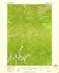
 1953 Salem1953 Print · USGSMid-century Oregon comes to life through this detailed survey of the Willamette Valley and the adjacent Pacific coastline. Researchers can trace the rail lines of the Southern Pacific RR, visit rural hubs like Fairview School, or locate coastal landmarks like the Yaquina Head Lighthouse.
 - 1954 Map of Salem
 1954 Salem1954 Print · USGSMid-century Western Oregon is centered on the productive Willamette River valley as its cities and infrastructure expand toward the mountains. Genealogists and historians can trace the rail lines of the Southern Pacific RR and Oregon Electric Ry through towns like Dallas, Independence, and Brownsville.
 - 1954 Map of Coos Bay
 1954 Coos Bay1954 Print · USGSCoastal Oregon at mid-century shows a landscape of timber and tides, from the river ports to the edge of the Pacific. Researchers can trace family roots through coastal schools like Beachview School or follow the Southern Pacific RR through Reedsport and Coos Bay.
 - 1954 Map of Anlauf, 1956 Print
 1954 Anlauf1956 Print · USGSThe Southern Pacific railroad and the Calapooya Divide define this Douglas County landscape in the mid-1950s. Trace old mercury mining operations at Elkhead Mines, locate the Anlauf Cemetery, or follow the early boundaries of the Cottage Grove Reservoir.3 unique versions available
 - 1955 Map of Hardesty Mtn, 1957 Print
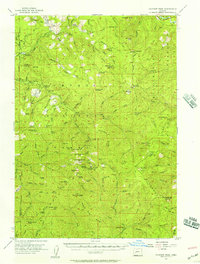
 1955 Hardesty Mtn1957 Print · USGSThe Willamette National Forest in the mid-fifties reveals a landscape defined by the newly formed Lookout Point Reservoir and timber operations. Genealogists and historians can trace the rail-side life of Westfir, locate the Westfir HS, or find old forest sites like Black Canyon Camp.3 unique versions available
 - 1955 Map of Illahee Rock, 1957 Print
 1955 Illahee Rock1957 Print · USGSUpper Douglas County in the mid-1950s was a landscape of forest service outposts and remote mountain camps along the river. Researchers can trace early backcountry locations like Illahee Guard Sta, the settlement of Steamboat, and the Winslow Cabin Spring.3 unique versions available
 - 1955 Map of Fairview Peak, 1957 Print
 1955 Fairview Peak1957 Print · USGSThe Oregon Cascades mining districts come to life in this mid-1950s survey of the Bohemia and Fairview mountain areas. Genealogists and researchers can trace the roads and trails leading to the Champion Mine, Musick Guard Station, and the Laying Creek Ranger Station.3 unique versions available
 - 1955 Map of Culp Creek, 1957 Print
 1955 Culp Creek1957 Print · USGSEastern Lane County in the mid-fifties is defined by the logging and rail corridor along the Row River. Researchers can trace the path of the Oregon and Eastern Railroad through settlements like Dorena and Disston, and locate landmarks like the Broumbaugh Cem.3 unique versions available
 - 1955 Map of Chucksney Mtn, 1958 Print
 1955 Chucksney Mtn1958 Print · USGSThe Willamette National Forest in the mid-1950s is shown as a network of fire lookouts and isolated forest camps. Researchers can trace historic administrative sites like the Waldo Guard Station and named high-country openings such as Salt Rock Prairie and Blair Meadow.3 unique versions available
 - 1955 Map of Blue River, 1958 Print
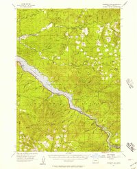
 1955 Blue River1958 Print · USGSThe Oregon Cascades in the mid-fifties reveal a landscape of active timbering and hard-rock mining along the McKenzie River. Researchers can trace the layout of early communities like Blue River and locate historic sites such as the Lucky Boy Mine and Renfrew Grave.2 unique versions available
 - 1955 Map of Cascadia, 1958 Print
 1955 Cascadia1958 Print · USGSThe South Santiam River corridor near Cascadia is documented here in the mid-1950s, showing a landscape of forest camps and mountain lookouts. Genealogists and hikers can trace early access roads to Upper Soda, Rainbow Falls, and the high ridges of Moose Ridge.3 unique versions available
 - 1955 Map of Echo Mountain, 1958 Print
 1955 Echo Mountain1958 Print · USGSHigh in the Cascades during the mid-fifties, this area shows the primitive forest camps and trail networks of the Willamette National Forest. Researchers can trace old mountain routes like the Browder Ridge Trail and locate sites such as Cool Camp and Tombstone Prairie.3 unique versions available
 - 1955 Map of Lowell, 1958 Print
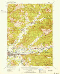
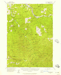
 1955 Lowell1958 Print · USGSUpper Willamette Valley life in the mid-fifties is captured here during a period of massive hydraulic change and timber growth. Researchers can trace the original rail lines of the Southern Pacific Railroad and locate vanished family landmarks near Cloverdale Cem and Butte Disappointment.3 unique versions available
 - 1955 Map of Mc Kenzie Bridge, 1958 Print
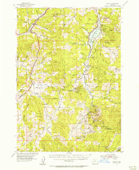
 1955 Mc Kenzie Bridge1958 Print · USGSThe McKenzie River valley in the mid-1950s shows a landscape of forest management and growing infrastructure. Genealogists and historians can trace the development of Cougar Dam and locate historic camps like Limberlost Forest Camp and Belknap Camp.3 unique versions available
 - 1955 Map of Crescent, 1963 Print
 1955 Crescent1963 Print · USGSCentral Oregon in the mid-1950s was a landscape of dense national forests and high desert expanses. Researchers can trace timber-era settlements like Gilchrist and Crescent or locate remote outposts such as Stauffer and Millican near the Wagontire Mountains.3 unique versions available
 - 1955 Map of Bend, 1964 Print
 1955 Bend1964 Print · USGSCentral Oregon was undergoing significant growth in the mid-1960s as irrigation and infrastructure transformed the high desert. Researchers can trace the path of the Oregon Trunk Line, locate old stops like Gateway, and find landmarks like Lava Butte or the Grange.3 unique versions available
 - 1956 Map of Toketee Falls
 1956 Toketee Falls1956 Print · USGSThe Oregon Cascades high country is shown here in the mid-fifties, just as hydroelectric development was transforming the river canyons. You can trace the complex water systems near Toketee Falls and find remote fire lookouts like Balm Lookout and Cinder Prairie Lookout.2 unique versions available
 - 1956 Map of Goodwin Peak, 1958 Print
 1956 Goodwin Peak1958 Print · USGSCoastal Oregon's deep river valleys and high forest ridges are captured here in the mid-fifties, showing the rugged boundary of Lane and Douglas counties. Researchers can locate remote family landmarks like Dailey Ranch, the Smith River Grange, and Sulphur Springs.2 unique versions available
 - 1956 Map of Waldo Lake, 1958 Print
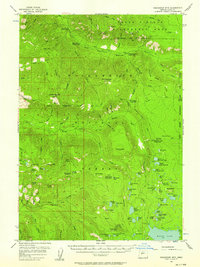
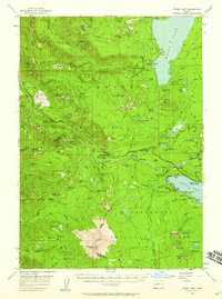 1956 Waldo Lake1958 Print · USGSThe high Cascades at the mid-point of the century were a realm of alpine lakes and steam-age rail routes. Genealogists and historians can trace old camps and stations along the Southern Pacific Railroad, from Beamer Ranch to the Cascade Summit overlook.3 unique versions available
Showing maps 1-25 of 48
Top cities of Lane County
- Eugene historical maps
- Springfield historical maps
- Cottage Grove historical maps
- Florence historical maps
- Junction City historical maps
- Creswell historical maps
See more
Frequently asked questions
- What are the different types of historical maps available for Lane County?
- What is the oldest map of Lane County?
- Where can I purchase historical maps of Lane County for my home or office?
- Where can I download high-res historical maps of Lane County?
- Are there historical topographic maps available for Lane County?
- Is there historical aerial imagery available for Lane County?
- Where are historical maps of Lane County sourced from?