1960s Maps of Lane County, Oregon
Explore 16 historic maps of Lane County from the 1960s. These maps offer a rare glimpse into what life looked like during the 1960s — showing old roads, neighborhoods, homes, and landmarks that have changed or disappeared over time.
Whether you're researching your family's past, planning a metal detecting trip, or studying how Lane County's landscape evolved across the 1960s, these high-resolution maps are a powerful tool for exploring the history of this region.
- Focus on a specific era: All maps on this page are from the 1960s, giving you a focused view of this time period.
- See what’s changed: Compare century-old streets, trails, and buildings to today's modern landscape using overlays and satellite layers.
- Research with precision: Use these maps for genealogy, historical research, land use analysis, or educational projects.
- View, download, or print: Maps are fully viewable online in high resolution, and can be downloaded or printed for your own records.
Start exploring Lane County's history through authentic maps from the 1960s. This is your window into the past.
Lane County, OR maps
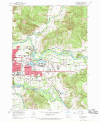
(16)- 1960 Map of Salem, 1968 Print
 1960 Salem1968 Print · USGSThe Willamette Valley and the surrounding mountain ranges are shown here in the 1960s during a period of significant reservoir construction. Genealogists and historians can trace rail lines like the Oregon Electric and find communities from Lincoln City on the coast to Sweet Home and Mill City in the foothills.2 unique versions available
 - 1962 Map of Salem
 1962 Salem1962 Print · USGSThe Willamette Valley and the surrounding Oregon ranges are captured here in the early sixties, showing the vital growth of the state's primary agricultural and academic corridor. Researchers can trace the mid-century footprints of Oregon State University and the University of Oregon, alongside rural landmarks like Camp Adair and Black Butte Mine.
 - 1962 Map of Coos Bay
 1962 Coos Bay1962 Print · USGSThe Oregon coast at the end of the fifties reveals a landscape of timber ports and fishing villages connected by U.S. Highway 101. Researchers can trace the rail infrastructure of the Southern Pacific RR and locate early settlements from Florence down to Brookings.2 unique versions available
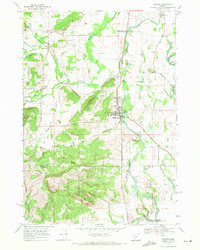
 - 1963 Map of Elk Lake
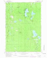 1963 Elk Lake1963 Print · USGSThe high Cascades come into focus during the early 1960s, showing a landscape of volcanic craters and alpine lakes. Researchers can locate established forest sites like Beach Campground, trace the Oregon Skyline Trail, and find local landmarks such as Red Crater.4 unique versions available
 - 1963 Map of Salem
 1963 Salem1963 Print · USGSMid-century Oregon comes into focus as the Willamette Valley’s timber and agricultural industries meet the growing campuses of Oregon State University and the University of Oregon. Researchers can trace old rail lines like the Oregon Electric Railway and locate family plots at Siletz Cem or Dallas Cem.
 - 1963 Map of The Twins, 1965 Print
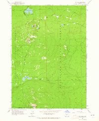 1963 The Twins1965 Print · USGSThe High Cascades along the Lane and Deschutes county line are captured here in the early sixties, showing a wilderness of volcanic peaks and alpine lakes. Hikers and historians can trace the paths of the Skyline Trail and Twins Trail past Charlton Lake, Gerdine Butte, and Maiden Peak.4 unique versions available
 - 1963 Map of Irish Mountain, 1965 Print
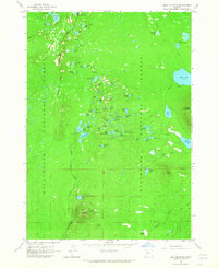 1963 Irish Mountain1965 Print · USGSThe Oregon Cascades straddle the county line in the early 1960s, showing a landscape of alpine lakes and volcanic peaks. Trace the historic route of the Skyline Trail past Irish Mountain and find backcountry landmarks like the Irish Lake Campground.3 unique versions available
 - 1963 Map of Packsaddle Mtn, 1965 Print
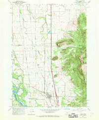
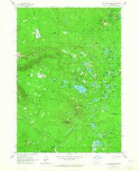 1963 Packsaddle Mtn1965 Print · USGSThe high Cascade divide between Lane and Deschutes counties is captured in the early sixties, showing the vital corridors of the central Oregon backcountry. You can trace the historic Oregon Skyline Trail as it passes through the Willamette National Forest near Packsaddle Mountain and Dumbbell Lake.4 unique versions available
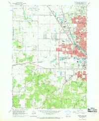
 - 1967 Map of Eugene East
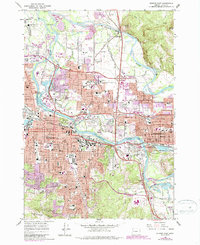 1967 Eugene East1967 Print · USGSMid-century development transforms the Willamette Valley as the university and suburbs expand across the river plain. Researchers can locate specific sites from the University of Oregon, Autzen Stadium, and the Lane County Fairgrounds.3 unique versions available
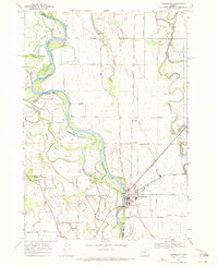
 - 1967 Map of Junction City, 1968 Print
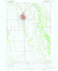 1967 Junction City1968 Print · USGSJunction City and the surrounding Willamette Valley are captured in the late sixties as a vital hub of rail and river commerce. Researchers can trace family history through sites like Milliorn Cem, the Mahlon Sweet Airport, and the rural Wyatt Sch.3 unique versions available
 - 1967 Map of Walterville, 1969 Print
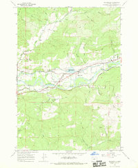 1967 Walterville1969 Print · USGSThe McKenzie River valley transitions from hydroelectric infrastructure to timbered ridges in the late sixties. Genealogists and local historians can trace family roots through the Camp Creek Cem, Walterville Sch, and the small settlement of Nye.3 unique versions available
 - 1967 Map of Coburg, 1969 Print
 1967 Coburg1969 Print · USGSIn the mid-1960s, the Willamette Valley near Coburg maintained a balance between its agricultural roots and developing infrastructure. Researchers can trace the Southern Pacific rail line, find family names at West Point Cem, and locate the small community of Daniels.
 - 1967 Map of Springfield, 1969 Print
 1967 Springfield1969 Print · USGSSpringfield at the height of its mid-century growth is documented here as a major hub for rail and river activity. Genealogists and local historians can trace the foundations of neighborhoods around Hendricks, Thurston, and the historic Mt Vernon Cem.5 unique versions available
 - 1967 Map of Eugene West, 1969 Print
 1967 Eugene West1969 Print · USGSThe western edges of Eugene were rapidly transforming in the late sixties as residential subdivisions began to fill the space between the railroad lines. Researchers can trace mid-century landmarks like the Mahlon Sweet Airport, the Balboa Park Drag Strip, and the historic Oak Hill Cemetery.3 unique versions available
 - 1969 Map of Harrisburg, 1971 Print
 1969 Harrisburg1971 Print · USGSHarrisburg sits at a vital junction of the Willamette River and dual rail lines during the late sixties. Researchers can trace family roots through the Masonic Cem or locate rural landmarks like the Covered Bridge and the village of Lancaster.
 - 1969 Map of Monroe, 1971 Print
 1969 Monroe1971 Print · USGSBenton and Lane counties are surveyed here in the late sixties, capturing the agricultural and timber corridor of the Willamette Valley. Genealogists can trace family names and sites such as Bellfountain Cem, Irish Bend Sch, and the settlement at Alpine.2 unique versions available
End of results
Showing maps 1-16 of 16
Top cities of Lane County
- Eugene historical maps
- Springfield historical maps
- Cottage Grove historical maps
- Florence historical maps
- Junction City historical maps
- Creswell historical maps
See more
Frequently asked questions
- What are the different types of historical maps available for Lane County?
- What is the oldest map of Lane County?
- Where can I purchase historical maps of Lane County for my home or office?
- Where can I download high-res historical maps of Lane County?
- Are there historical topographic maps available for Lane County?
- Is there historical aerial imagery available for Lane County?
- Where are historical maps of Lane County sourced from?