1930s Maps of Lane County, Oregon
Explore 6 historic maps of Lane County from the 1930s. These maps offer a rare glimpse into what life looked like during the 1930s — showing old roads, neighborhoods, homes, and landmarks that have changed or disappeared over time.
Whether you're researching your family's past, planning a metal detecting trip, or studying how Lane County's landscape evolved across the 1930s, these high-resolution maps are a powerful tool for exploring the history of this region.
- Focus on a specific era: All maps on this page are from the 1930s, giving you a focused view of this time period.
- See what’s changed: Compare century-old streets, trails, and buildings to today's modern landscape using overlays and satellite layers.
- Research with precision: Use these maps for genealogy, historical research, land use analysis, or educational projects.
- View, download, or print: Maps are fully viewable online in high resolution, and can be downloaded or printed for your own records.
Start exploring Lane County's history through authentic maps from the 1930s. This is your window into the past.
Lane County, OR maps
(6)- 1930 Map of Maiden Peak
 1930 Maiden Peak1930 Print · USGSThe high volcanic plateau of central Oregon is captured in the early 1930s as a landscape of new reservoirs and forest outposts. Genealogists and historians can trace family-named sites like Caldwell Ranch or follow early travel routes like Century Drive and the Southern Pacific rail line.3 unique versions available
 - 1932 Map of Three Sisters
 1932 Three Sisters1932 Print · USGSThe eastern Cascades and the high desert meet in the early 1930s as the regional highway system begins to pierce the mountains. Genealogists and historians can trace early settlements like Camp Polk and Sisters or locate old forest landmarks such as Camp Sherman and Black Butte.3 unique versions available
 - 1934 Map of Maiden Peak
 1934 Maiden Peak1934 Print · USGSCentral Oregon’s high desert and timberlands are captured here in the early thirties, centered on the Crane Prairie Reservoir. Researchers can find isolated outposts like Caldwell Ranch, the Log Cabin, and Lapine at the highway junction.3 unique versions available
 - 1934 Map of Mc Kenzie Bridge
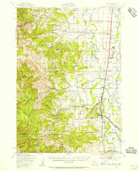
 1934 Mc Kenzie Bridge1934 Print · USGSThe Cascades in the mid-1930s were a network of forest guard stations, remote ranches, and early mountain resorts. Genealogists and historians can locate family landmarks such as Sims Ranch and Hardy Cabin or trace the early developments at Belknap Springs.
 - 1935 Map of Lowell
 1935 Lowell1935 Print · USGSIn the mid-1930s, this region of the Willamette foothills was a busy landscape of timber and rail. Researchers can trace rural school districts like Unity Sch, small post offices at Fall Creek PO, and the path of the Southern Pacific railroad.
 - 1939 Map of Monroe, 1956 Print
 1939 Monroe1956 Print · USGSBenton County agriculture and timber meet at the foot of the Coast Range in the late thirties. Genealogists can trace family footprints through the numerous rural school districts, including Beaver Creek Sch, or locate old rail stops at Alpine Junction and Burnett.
End of results
Showing maps 1-6 of 6
Top cities of Lane County
- Eugene historical maps
- Springfield historical maps
- Cottage Grove historical maps
- Florence historical maps
- Junction City historical maps
- Creswell historical maps
See more
Frequently asked questions
- What are the different types of historical maps available for Lane County?
- What is the oldest map of Lane County?
- Where can I purchase historical maps of Lane County for my home or office?
- Where can I download high-res historical maps of Lane County?
- Are there historical topographic maps available for Lane County?
- Is there historical aerial imagery available for Lane County?
- Where are historical maps of Lane County sourced from?