1960s Maps of Presidio County, Texas
Explore 4 historic maps of Presidio County from the 1960s. These maps offer a rare glimpse into what life looked like during the 1960s — showing old roads, neighborhoods, homes, and landmarks that have changed or disappeared over time.
Whether you're researching your family's past, planning a metal detecting trip, or studying how Presidio County's landscape evolved across the 1960s, these high-resolution maps are a powerful tool for exploring the history of this region.
- Focus on a specific era: All maps on this page are from the 1960s, giving you a focused view of this time period.
- See what’s changed: Compare century-old streets, trails, and buildings to today's modern landscape using overlays and satellite layers.
- Research with precision: Use these maps for genealogy, historical research, land use analysis, or educational projects.
- View, download, or print: Maps are fully viewable online in high resolution, and can be downloaded or printed for your own records.
Start exploring Presidio County's history through authentic maps from the 1960s. This is your window into the past.
Presidio County, TX maps
(4)- 1965 Map of Presidio
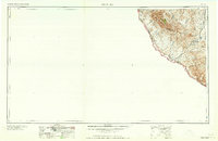 1965 Presidio1965 Print · USGSThe Big Bend borderlands appear in the mid-sixties as a rugged landscape of high-altitude ranching and retired mines. Trace the river road to the Old Fort Leaton ruins or locate family landmarks like Alamo Ranch and the Shafter Mine.
 - 1965 Map of Marfa
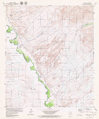
 1965 Marfa1965 Print · USGSBig Bend ranching and high-desert rail travel come together in the 1960s along the Rio Grande and the southern reaches of the Davis Mountains. Researchers can trace the lineage of cattle outfits like Brite Ranch and historic stops like Valentine and Candelaria.
 - 1965 Map of Emory Peak
 1965 Emory Peak1965 Print · USGSThe Big Bend backcountry in the mid-1960s reveals a desert landscape of remote ranches and mercury mining. Trace the historic boundary along the Rio Grande and locate landmarks like the Fresno Mine and Panther Spring.
 - 1966 Map of Adobes, 1969 Print
 1966 Adobes1969 Print · USGSThe Texas-Mexico borderlands come into sharp focus in the 1970s as the Rio Grande Bravo winds past remote outposts. Researchers can trace family history at the Adobe Cemetery or locate vanished infrastructure like the desert landing strip.
End of results
Showing maps 1-4 of 4
Top cities of Presidio County
- Presidio historical maps
- Marfa historical maps
- Redford historical maps
- Candelaria historical maps
- Ruidosa historical maps
- Plata historical maps
See more
Frequently asked questions
- What are the different types of historical maps available for Presidio County?
- What is the oldest map of Presidio County?
- Where can I purchase historical maps of Presidio County for my home or office?
- Where can I download high-res historical maps of Presidio County?
- Are there historical topographic maps available for Presidio County?
- Is there historical aerial imagery available for Presidio County?
- Where are historical maps of Presidio County sourced from?