1940s Maps of Washington
Explore 149 historic maps of Washington from the 1940s. These maps offer a rare glimpse into what life looked like during the 1940s — showing old roads, neighborhoods, homes, and landmarks that have changed or disappeared over time.
Whether you're researching your family's past, planning a metal detecting trip, or studying how Washington's landscape evolved across the 1940s, these high-resolution maps are a powerful tool for exploring the history of this region.
- Focus on a specific era: All maps on this page are from the 1940s, giving you a focused view of this time period.
- See what’s changed: Compare century-old streets, trails, and buildings to today's modern landscape using overlays and satellite layers.
- Research with precision: Use these maps for genealogy, historical research, land use analysis, or educational projects.
- View, download, or print: Maps are fully viewable online in high resolution, and can be downloaded or printed for your own records.
Start exploring Washington's history through authentic maps from the 1940s. This is your window into the past.
Washington maps
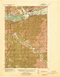
(149)- 1940 Map of Lookout Mtn
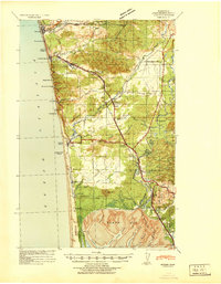
 1940 Lookout Mtn1940 Print · USGSSkamania County's high country is documented here just before the mid-century, showing a landscape of fire lookouts and forest camps. Researchers can trace early ranger infrastructure and remote sites like the Summit Guard Station, 4th of July Camp, and the Miners site near Copper Creek.
 - 1940 Map of Hillsboro
 1940 Hillsboro1940 Print · USGSThe Tualatin Valley and the Columbia River confluence meet in this 1940 survey of the Hillsboro and North Portland region. Researchers can trace early twentieth-century rail lines like the Oregon Electric or locate historic rural landmarks such as Mountain View Cemetery and the Mason Hill School.
 - 1940 Map of Tenino
 1940 Tenino1940 Print · USGSThurston County’s rail and timber landscape is documented here at the start of the 1940s, showing a critical intersection of three major railroads. Genealogists and local historians can trace the rural school districts of Spurgeon Creek Sch and the industrial footprint of the Panama Lumber & Shingle Co.
 - 1940 Map of Port Gamble
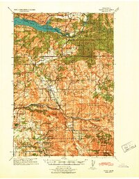
 1940 Port Gamble1940 Print · USGSThe Kitsap Peninsula and Hood Canal are seen here in the final years before the bridge era, when a complex network of ferries was the lifeblood of the sound. Genealogists and local historians can trace the early footprints of Port Gamble, Hansville, and the Port Madison Indian Reservation.
 - 1940 Map of Point Misery
 1940 Point Misery1940 Print · USGSCoastal life along the Hood Canal and Dabob Bay is caught in detail just before the mid-century, from timber operations to maritime crossings. Genealogists and historians can trace the Brinnon Seabeck Ferry, identify the Barney White Ranch, and locate the Seabeck Sch.
 - 1940 Map of Montesano
 1940 Montesano1940 Print · USGSGrays Harbor and Pacific counties were defined by a massive river-and-rail network just before the war. You can trace the path of the Northern Pacific through Montesano or locate old timber operations along the Logging lines near Arctic and Vesta.
 - 1940 Map of Quilcene
 1940 Quilcene1940 Print · USGSThe Olympic Peninsula shoreline and timbered foothills are captured here during the late pre-war era, from the heights of Mt Walker to the depths of Dabob Bay. Researchers can trace early logging operations at Mc Cormack Lumber Co or locate civic landmarks like the Port Townsend Dam and US Fish Hatchery.
 - 1940 Map of Brookfield
 1940 Brookfield1940 Print · USGSPacific and Wahkiakum Counties are shown in detail during the early 1940s, highlighting the heavy industrial presence along the Columbia River shoreline. Researchers can locate salmon canneries, logging camps, and family holdings such as the Pillar Rock Cannery, Old Camp Brix Logging Co, and Maki Ranch.
 - 1940 Map of Anderson Island
 1940 Anderson Island1940 Print · USGSCoastal Washington at the start of the 1940s shows a landscape of strategic military installations and island prisons. You can trace the development of Fort Lewis, the boundaries of the Nisqually Indian Reservation, and the layout of the Federal Penitentiary on McNeil Island.
 - 1940 Map of South Bend
 1940 South Bend1940 Print · USGSPacific County's maritime and ranching history is preserved here during the late thirties, centered on the river port of South Bend. Genealogists and historians can locate old family landmarks like Minks Ranch, Dwyer Store, and the coastal retreat at Rhodesia Beach.
 - 1940 Map of Portland
 1940 Portland1940 Print · USGSThe Portland and Vancouver riverfronts are captured here just before the massive industrial shifts of the mid-century. Genealogists and historians can locate early landmarks like Vancouver Barracks, the University of Portland, and Mundays Ferry.4 unique versions available
 - 1940 Map of La Center
 1940 La Center1940 Print · USGSClark County, Washington, is shown just before the war as a landscape of river-valley farms and timber outposts. Researchers can trace family roots through named intersections like Dollar Corner and Scotton Corner or locate vanished sites like the Ariel School.
 - 1940 Map of Mt Vernon, 1957 Print
 1940 Mt Vernon1957 Print · USGSThe Skagit River delta and its thriving rail-and-river towns are captured here just before the mid-century. Genealogists can trace family roots through numerous country schools like Harmony Sch and landmarks like the Milltown Ch or the timber-hauling Logging Railroad.2 unique versions available
 - 1941 Map of Black Rock Spring
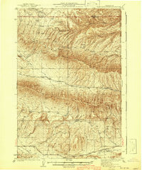 1941 Black Rock Spring1941 Print · USGSThe high desert of Yakima and Kittitas Counties comes to life in the years before the war, showing a landscape shaped by ranching and deep basalt canyons. Researchers can trace historic family holdings like the Stewart Ranch and Coffin Ranch, or locate the isolated Taylor Sch.2 unique versions available
 - 1941 Map of Walville
 1941 Walville1941 Print · USGSThe timber country and rail towns of southwest Washington are captured here just before the Second World War. Researchers can trace family sites at the Habersetzer Farm, locate the Brittian-Chandler CCC Camp, or follow the Northern Pacific RR through Pe Ell.
 - 1941 Map of Yacolt
 1941 Yacolt1941 Print · USGSIn the early 1940s, Clark County's timber and river country centered on the rail-connected town of Yacolt. Researchers can trace old homesteads and landmarks like Golden Wonder Mine, Riverview School, and the remote Sunset Guard Sta.
 - 1941 Map of Meskill
 1941 Meskill1941 Print · USGSLewis County at the start of the Second World War shows a landscape defined by timber camps and river valleys. Genealogists can trace family roots through Claquato Cem or follow the vanished operations of Schafer Bros Logging Camp No 10.2 unique versions available
 - 1941 Map of Yakima East
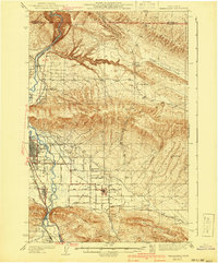 1941 Yakima East1941 Print · USGSThe Yakima Valley was a hub of irrigation and rail transport in the early 1940s, as intensive canal networks reshaped the landscape. Local historians can trace family homesteads along Beaudry Road and Charon Rd, or locate the First Reformed Ch and the State Fairgrounds.2 unique versions available
 - 1941 Map of Mobray
 1941 Mobray1941 Print · USGSCoastal Washington timberlands and river valleys come into focus in the early 1940s as industrial logging expands. Trace old family sites and works like Mobray, the Wynoochee Valley Farm, and the Simpson Logging Co Road.
 - 1941 Map of Moclips
 1941 Moclips1941 Print · USGSThe Grays Harbor coastline was a bustling corridor of timber and milling just before the war. Researchers can trace the extensive Polson Logging Company rail lines, the Carlisle School, and industrial sites like the Stearns Shingle Mill.
 - 1941 Map of St Helens
 1941 St Helens1941 Print · USGSThe Columbia River waterfront near St. Helens was a thriving industrial and agricultural corridor just before the war. Trace old rail stops at Honeymoon Sta, rural schoolhouses like Shilo Basin Sch, and the shifting river islands from Deer Island to Bachelor Island.
 - 1941 Map of Olequa
 1941 Olequa1941 Print · USGSSouthwestern Washington on the eve of the Second World War shows a landscape defined by the Cowlitz River and the Northern Pacific rail line. Genealogists can trace early homesteads along Winlock to Toledo Road or locate family roots near St Francis Mission and Silver Lake.
 - 1941 Map of Gate
 1941 Gate1941 Print · USGSThurston and Grays Harbor counties were bustling with rail and timber activity just before the mid-century. Researchers can trace the junction of four railroads near Gate or locate early rural sites like the Michigan Hill Sch and Jewelstock Ranch.
 - 1941 Map of Skamokawa
 1941 Skamokawa1941 Print · USGSWahkiakum County's timber and river culture is captured here during the early 1940s, showing the intersection of logging camps and Columbia River fisheries. Researchers can locate family landmarks like the Oatfield Ranch, trace the Crown Willamette Headquarters Camp, or find the Fern Hill Cemetery.
 - 1941 Map of Tanwax Lake
 1941 Tanwax Lake1941 Print · USGSPierce County was a busy corridor for timber and defense just before the war, as shown in this detailed 1941 survey. Genealogists and historians can locate Camp 1 Logging Camp, the old Lacamas School, and the winding Chicago Milwaukee St Paul and Pacific rail line.
Showing maps 1-25 of 149
Top cities of Washington
- Seattle historical maps
- Spokane historical maps
- Tacoma historical maps
- Vancouver historical maps
- Bellevue historical maps
- Kent historical maps
See more
Top counties of Washington
- King County historical maps
- Pierce County historical maps
- Snohomish County historical maps
- Spokane County historical maps
- Clark County historical maps
- Thurston County historical maps
See more
Frequently asked questions
- What are the different types of historical maps available for Washington?
- What is the oldest map of Washington?
- Where can I purchase historical maps of Washington for my home or office?
- Where can I download high-res historical maps of Washington?
- Are there historical topographic maps available for Washington?
- Is there historical aerial imagery available for Washington?
- Where are historical maps of Washington sourced from?