1910s Maps of Washington
Explore 37 historic maps of Washington from the 1910s. These maps offer a rare glimpse into what life looked like during the 1910s — showing old roads, neighborhoods, homes, and landmarks that have changed or disappeared over time.
Whether you're researching your family's past, planning a metal detecting trip, or studying how Washington's landscape evolved across the 1910s, these high-resolution maps are a powerful tool for exploring the history of this region.
- Focus on a specific era: All maps on this page are from the 1910s, giving you a focused view of this time period.
- See what’s changed: Compare century-old streets, trails, and buildings to today's modern landscape using overlays and satellite layers.
- Research with precision: Use these maps for genealogy, historical research, land use analysis, or educational projects.
- View, download, or print: Maps are fully viewable online in high resolution, and can be downloaded or printed for your own records.
Start exploring Washington's history through authentic maps from the 1910s. This is your window into the past.
Washington maps
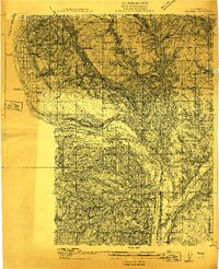
(37)- 1910 Map of Zillah
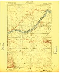
 1910 Zillah1910 Print · USGSThe Yakima River valley was transforming into an agricultural hub in the early 1900s as irrigation projects expanded. Researchers can trace the path of the Northern Pacific railroad through Toppenish and Wapato, or locate early sites like the Sawmill and Bluelight.3 unique versions available
 - 1910 Map of Quincy
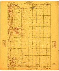 1910 Quincy1910 Print · USGSGrant County is captured in a moment of early expansion as homesteaders settled the basin during the first decade of the century. Genealogists can trace family roots through numerous rural landmarks like Evergreen School, Burke, and Haywood School.4 unique versions available
 - 1910 Map of Winchester
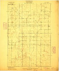 1910 Winchester1910 Print · USGSGrant County is captured in the early twentieth century as rural homesteaders began to settle the semi-arid landscape along the Great Northern RR. Researchers can locate early rural landmarks including Winchester and five distinct schools such as Dishaw School and McEwen School.3 unique versions available
 - 1910 Map of Pullman
 1910 Pullman1910 Print · USGSThe Palouse hills and Snake River breaks are shown here in the early twentieth century, during a period of rapid railway expansion and academic growth. Genealogists and historians can trace the early layouts of Pullman and Colfax, as well as rural post offices like Guy Albion PO and the campus of the State College of Washington.5 unique versions available
 - 1911 Map of Mount Vernon
 1911 Mount Vernon1911 Print · USGSSkagit and Snohomish counties are shown here just after the turn of the century as the railroad and river networks fueled rapid growth. Researchers can trace historic transportation routes like the Anderson Ferry and the Monte Cristo RR through Mount Vernon and the Tulalip Indian Reservation.4 unique versions available
 - 1911 Map of Red Rock
 1911 Red Rock1911 Print · USGSGrant County is captured during the arrival of the transcontinental railroad in the early twentieth century. Genealogists and researchers can trace the early rail stops at Smyrna and Colletta or locate rural landmarks like Sumner School and Joyces Ranch.2 unique versions available
 - 1912 Map of Moses Lake
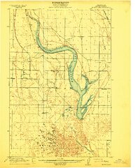 1912 Moses Lake1912 Print · USGSGrant County is captured in the early twentieth century before the major irrigation projects reshaped the desert. Genealogists can locate family holdings near Mae or trace the early paths to Hiawatha School and the unique geography of The Potholes.6 unique versions available
 - 1912 Map of Beverly
 1912 Beverly1912 Print · USGSCentral Washington is captured here at a pivotal moment just after the arrival of the railroad. You can trace the path of the Chicago Milwaukee and Puget Sound RR through riverfront settlements like Beverly and Cohassett.6 unique versions available
 - 1912 Map of Malaga
 1912 Malaga1912 Print · USGSCentral Washington's river-driven development is on display here just before the era of major hydroelectric projects. Genealogists and historians can trace an incredible density of early schools like Lower Stemilt School and settlements like Malaga and Vulcan.2 unique versions available
 - 1913 Map of Cedar Lake
 1913 Cedar Lake1913 Print · USGSThe foothills and peaks of the Cascades appear here just before World War I as industry pushed into the wilderness. Trace early timber and rail history through Kerriston, Selleck, and the Cedar Falls Power Plant.5 unique versions available
 - 1913 Map of Wenatchee, 1964 Print
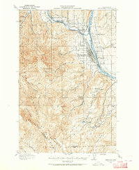 1913 Wenatchee1964 Print · USGSThe Wenatchee River valley and Columbia River shoreline thrived in the early 1910s as a burgeoning agricultural and rail hub. Genealogists can trace early homesteads and landmarks like Martins Ranch, the Great Northern Railway, and rural sites like Pitcher School.
 - 1914 Map of Malaga
 1914 Malaga1914 Print · USGSCentral Washington ranching and rail life are captured here just before World War I, centered on the Columbia River corridor. Genealogists and local historians can locate early homesteads and landmarks like the Sheehan Ranch, Malaga, and Liberty School.3 unique versions available
 - 1915 Map of Wenatchee
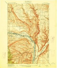
 1915 Wenatchee1915 Print · USGSWenatchee and the Columbia River valley are shown in the years before major dam construction, when the region's orchard economy was firmly established. Researchers can trace early railroad history along the Great Northern or locate rural landmarks like Mortins Ranch and Ferry School.3 unique versions available
 - 1915 Map of Hillsboro
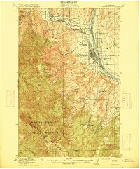
 1915 Hillsboro1915 Print · USGSThe Tualatin Valley and the confluence of the Columbia and Willamette rivers are shown here at the peak of the electric rail era. Researchers can trace historic family schoolhouses like Mason Hill School and vanished landings such as Blurock Landing.
 - 1915 Map of Wallulah
 1915 Wallulah1915 Print · USGSThe convergence of the Snake and Columbia rivers in the mid-1910s reveals a landscape defined by steam power and irrigation. Genealogists and rail historians can trace early settlements like Attalia and Two Rivers alongside the path of the Oregon-Washington RR & Nav Co.
 - 1915 Map of Mt. Baker, 1925 Print
 1915 Mt. Baker1925 Print · USGSUpper Whatcom and Skagit counties are seen here in the early twentieth century as railroads and mines began to pierce the wilderness. Genealogists and historians can locate early homesteads like Morovits Ranch, the Lone Jack Mine, and the route of the Great Northern railroad.3 unique versions available
 - 1915 Map of Prosser, 1957 Print
 1915 Prosser1957 Print · USGSThe Yakima Valley thrived as a rail and irrigation hub during the early twentieth century. Researchers can trace the layout of early schools and family-named homesteads like Orchard Ridge School, Snively Ranch, and the town of Prosser.
 - 1916 Map of Connell
 1916 Connell1916 Print · USGSIn the decade before the region's landscape was further transformed by modern irrigation, this area shows a dense network of early schoolhouses and railroad stops. Genealogists can trace family footprints through sites like Roxboro School, Hatton, and Kahlotus along the Washtucna Lake shoreline.
 - 1916 Map of Arlington
 1916 Arlington1916 Print · USGSThe Columbia River frontier of the mid-1910s reveals a world where the Oregon Trail and early railroads met the water. Genealogists can trace family roots through rural landmarks like Stegeman Ranch, Shutler, and the Locust Grove School.4 unique versions available
 - 1916 Map of Chehalis
 1916 Chehalis1916 Print · USGSDuring a period of rapid development along the Chehalis and Skookumchuck Rivers, these valleys supported a thriving network of timber camps and rail towns. Genealogists can trace family landmarks like Logan Hill School, the Centralia Seminary, and the Salmon Creek Mill.4 unique versions available
 - 1916 Map of Coyote Rapids
 1916 Coyote Rapids1916 Print · USGSBenton and Grant counties meet along a wild stretch of the Columbia River during the mid-1910s. Researchers can trace the early railroad stops at Allard and Haven, the site of Coyote Rapids, and the irrigation works of the Benson Ditch.3 unique versions available
 - 1917 Map of Pasco
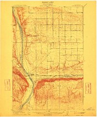
 1917 Pasco1917 Print · USGSThe confluence of the Columbia and Snake rivers in the early twentieth century shows a region being reshaped by irrigation and rail. Genealogists can trace family holdings and rural schoolhouses like Baxter School, the Farnsworth Ranch, and the Zimmerman Ferry.4 unique versions available
 - 1917 Map of Priest Rapids
 1917 Priest Rapids1917 Print · USGSThe Columbia River bend and the high country of the Rattlesnake Hills are captured here during a period of early ranching and river industry. Genealogists and historians can locate remote outposts like Figure 2 Ranch, the site of Vernita, and the vital Richmond Ferry.2 unique versions available
 - 1917 Map of Prosser
 1917 Prosser1917 Print · USGSBenton and Yakima counties thrive in the late teens as irrigation and rail lines transform the desert floor into a budding agricultural hub. Researchers can trace early family homesteads like Benson Ranch and numerous rural landmarks like Buena Vista School and the Gas Well.2 unique versions available
 - 1918 Map of Port Angeles
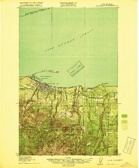 1918 Port Angeles1918 Print · USGSThe northern Olympic Peninsula comes to life in the years following the Great War, showing a landscape defined by maritime trade and logging. Genealogists and historians can locate early landmarks like Reeveton, the Ennis Creek Ranger Station, and several rural schools including Fairview School.4 unique versions available
Showing maps 1-25 of 37
Top cities of Washington
- Seattle historical maps
- Spokane historical maps
- Tacoma historical maps
- Vancouver historical maps
- Bellevue historical maps
- Kent historical maps
See more
Top counties of Washington
- King County historical maps
- Pierce County historical maps
- Snohomish County historical maps
- Spokane County historical maps
- Clark County historical maps
- Thurston County historical maps
See more
Frequently asked questions
- What are the different types of historical maps available for Washington?
- What is the oldest map of Washington?
- Where can I purchase historical maps of Washington for my home or office?
- Where can I download high-res historical maps of Washington?
- Are there historical topographic maps available for Washington?
- Is there historical aerial imagery available for Washington?
- Where are historical maps of Washington sourced from?