1900s (20th Century) Maps of Okanogan County, Washington
Explore 193 historic maps of Okanogan County from the 1900s (20th Century). These maps offer a rare glimpse into what life looked like during the 1900s — showing old roads, neighborhoods, homes, and landmarks that have changed or disappeared over time.
Whether you're researching your family's past, planning a metal detecting trip, or studying how Okanogan County's landscape evolved across the 1900s, these high-resolution maps are a powerful tool for exploring the history of this region.
- Focus on a specific era: All maps on this page are from the 1900s, giving you a focused view of this time period.
- See what’s changed: Compare century-old streets, trails, and buildings to today's modern landscape using overlays and satellite layers.
- Research with precision: Use these maps for genealogy, historical research, land use analysis, or educational projects.
- View, download, or print: Maps are fully viewable online in high resolution, and can be downloaded or printed for your own records.
Start exploring Okanogan County's history through authentic maps from the 1900s. This is your window into the past.
Okanogan County, WA maps
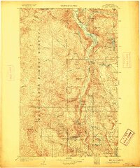
(193)- 1901 Map of Chelan
 1901 Chelan1901 Print · USGSNorth Central Washington is captured at the dawn of the twentieth century, showing the early development of the lake and river valleys. Researchers can trace the original Wapato Indian Reservation boundary and locate early townsites like Lakeside and Waterville.6 unique versions available
 - 1901 Map of Methow
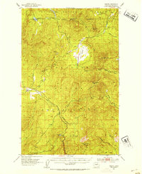
 1901 Methow1901 Print · USGSThe Methow Valley at the turn of the century was a frontier of early settlements and protected forest reserves. Genealogists and historians can trace the early footprints of Winthrop and Silver, or locate landmarks along Sawtooth Ridge and the shores of Lake Chelan.6 unique versions available
 - 1902 Map of Osoyoos
 1902 Osoyoos1902 Print · USGSOkanogan County at the dawn of the twentieth century was a landscape of high-country mines and riverfront settlements along the Canadian border. Genealogists and historians can trace early mining operations at Okanogan Free Gold Mine or locate early towns like Molson, Chesaw, and Oroville.
 - 1902 Map of Stehekin, 1955 Print
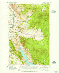
 1902 Stehekin1955 Print · USGSLake Chelan and the North Cascades are captured here at the dawn of the twentieth century, during a period of remote mountain development. Genealogists and historians can trace early settlements at Stehekin, Lucerne, and Gilbert, along with the route of the Holden Railroad.2 unique versions available
 - 1904 Map of Osoyoos
 1904 Osoyoos1904 Print · USGSOkanogan County near the Canadian border is shown here during a period of mining expansion and early ranching. You can trace the proximity of the Okanogan Free Gold Mine to Oroville or locate early settlements like Molson, Chesaw, and Huntley Ranch.3 unique versions available
 - 1904 Map of Stehekin
 1904 Stehekin1904 Print · USGSThe northern reaches of Lake Chelan are captured here at the turn of the century, showing a wilderness being shaped by early mountain outposts and mining. Genealogists and researchers can trace remote sites like Gilbert and Holden, or the unique path of the Holden Railroad.5 unique versions available
 - 1904 Map of Republic
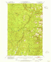
 1904 Republic1904 Print · USGSFerry County was at the height of its gold boom in the early nineteen-hundreds, anchored by the rapid growth of Republic. Genealogists and historians can trace the early rail stops and mine sites of the era, from the Lone Star Mine to the depot at Seward Station.4 unique versions available
 - 1905 Map of Okanogan
 1905 Okanogan1905 Print · USGSThe Okanogan and Columbia rivers converge in this early 1900s survey, showing the region when river ferries were the primary links between frontier settlements. Researchers can trace the original locations of Bruster, Alma, and Olema, or locate historical river crossings like Central Ferry and Andrews Ferry.3 unique versions available
 - 1906 Map of Chopaka
 1906 Chopaka1906 Print · USGSNorthern Washington at the turn of the century shows a frontier defined by mining camps and mountain passes along the Canadian border. Trace the early Okanogan mining boom through the Grandview Mine, the remote Nighthawk settlement, and Conconully.3 unique versions available
 - 1920 Map of Slate Pass
 1920 Slate Pass1920 Print · USGSThe North Cascades high country at the start of the 1920s reveals a wilderness of newly surveyed peaks and vital mountain passes. Trace early forest and mining routes through Slate Pass and Harts Pass or locate the remote Chancellor Power Plant.
 - 1948 Map of Grand Coulee Dam, 1955 Print
 1948 Grand Coulee Dam1955 Print · USGSThe Grand Coulee region underwent a massive transformation by the late 1940s as the dam transformed the river valley into a sprawling reservoir. Trace the growth of Coulee Dam and Grand Coulee, and locate rural landmarks like the Grand Coulee Grange and Bagdad Junction.6 unique versions available
 - 1950 Map of Grand Coulee Dam
 1950 Grand Coulee Dam1950 Print · USGSThe Grand Coulee region during the late 1940s reveals a landscape transformed by the new reservoir and the massive engineering of the dam. Researchers can trace local history through the Lafollette Cem, the community at Elmer City, and rural sites like the Grand Coulee Grange.2 unique versions available
 - 1950 Map of Nespelem, 1952 Print
 1950 Nespelem1952 Print · USGSWithin the Colville Indian Reservation at mid-century, this area shows the transition from mountain lakes to the Columbia River shore. You can trace early settlements and agency sites like Nespelem, Koontzville, and the Colville Indian Agency during a period of significant regional change.4 unique versions available
 - 1950 Map of Boot Mtn, 1952 Print
 1950 Boot Mtn1952 Print · USGSThe Okanogan highlands meet the Columbia River in the early 1950s within the Colville Indian Reservation. Trace rural life through the Condon Ferry (Site) and several remote schoolhouses like Long Lake Sch.3 unique versions available
 - 1950 Map of Alameda Flat, 1965 Print
 1950 Alameda Flat1965 Print · USGSThe Columbia River flows through Okanogan and Douglas counties in the early 1950s, defining the rugged boundary of the Colville Indian Reservation. Genealogists and local historians can locate the Rex Grange Hall, Del Rio Cemetery, and several legacy mining sites like the Apache Mine.2 unique versions available
 - 1951 Map of Wauconda
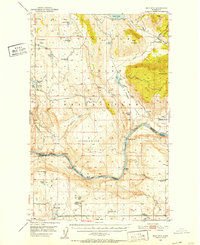
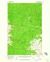
 1951 Wauconda1951 Print · USGSOkanogan and Ferry counties were centers of high-country mining and forestry during the early fifties. Genealogists and historians can locate the Knob Hill Mine, Tom Thumb Mine, and the Lookout at Sheep Mtn alongside the remote Sheridan Road.2 unique versions available
 - 1951 Map of Bodie Mountain
 1951 Bodie Mountain1951 Print · USGSNorthern Washington mountain life and mining are documented here at mid-century as the forest services mapped the high ridges. Trace local sites like the Sheridan Mine, the settlement of Toroda, and peaks from Harvard Mtn to Hardscrabble Mtn.
 - 1952 Map of Alameda Flat
 1952 Alameda Flat1952 Print · USGSOkanogan County settlement and industry are captured here in the early fifties along the Columbia River. Genealogists and historians can trace several closed schools like Rex School and remote mining sites including the Apache Mine.
 - 1952 Map of Disautel, 1954 Print
 1952 Disautel1954 Print · USGSHigh in the Okanogan country during the early fifties, this area shows the intersection of the Colville Indian Reservation and federal forest lands. Researchers can locate the settlement of Disautel and trace old mountain routes past Moses Mountain and Crawfish Lake.3 unique versions available
 - 1953 Map of Bald Knob, 1955 Print
 1953 Bald Knob1955 Print · USGSThe Okanogan highlands in the early 1950s show a landscape of tribal lands and national forests at the peak of the fire lookout era. Genealogists and historians can trace the Colville Indian Reservation boundaries and find remote sites like Bungalow Mine or Owhi Lake.3 unique versions available
 - 1953 Map of Omak Lake, 1956 Print
 1953 Omak Lake1956 Print · USGSThe Okanogan River valley and the Colville Indian Reservation are captured here in the early fifties, showing the region's transition into the modern era. Genealogists and historians can trace the Great Northern rail line and locate landmarks like St Marys Mission and the settlement of Riverside.2 unique versions available
 - 1953 Map of Ritzville, 1966 Print
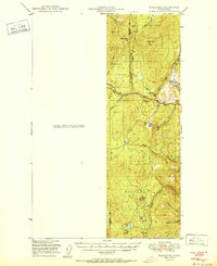
 1953 Ritzville1966 Print · USGSEastern Washington was undergoing a massive agricultural and industrial transformation in the mid-fifties as irrigation from the Grand Coulee Dam reached the plateau. Researchers can trace the mid-century rail network of the Great Northern and locate vital local sites like Larson Air Force Base and Odessa.3 unique versions available
 - 1954 Map of Okanogan, 1964 Print
 1954 Okanogan1964 Print · USGSNorth Central Washington’s interior comes into focus during the mid-fifties, showing the rise of the Columbia River reservoir system. Genealogists and historians can trace the Great Northern rail line and locate historical mining operations at the Mountain Lion Mine or Gold Hill Mine.2 unique versions available
 - 1955 Map of Concrete, 1967 Print
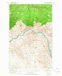
 1955 Concrete1967 Print · USGSThe North Cascades in the mid-fifties reveal a landscape of deep glacier-fed lakes and riverside timber towns. You can trace the Great Northern rail lines through Granite Falls or locate remote outposts like Stehekin and Marblemount along the Skagit and Chelan waters.
 - 1956 Map of Loup Loup, 1959 Print
 1956 Loup Loup1959 Print · USGSThe Okanogan highlands in the mid-1950s come to life on this sheet through a rugged landscape of mining claims and mountain ranching. Researchers can trace the legacy of the Red Shirt Mine or locate family homesteads like Stout Ranch and Olema.2 unique versions available
Showing maps 1-25 of 193
Top cities of Okanogan County
- Omak historical maps
- Okanogan historical maps
- Brewster historical maps
- Oroville historical maps
- Tonasket historical maps
- Twisp historical maps
See more
Frequently asked questions
- What are the different types of historical maps available for Okanogan County?
- What is the oldest map of Okanogan County?
- Where can I purchase historical maps of Okanogan County for my home or office?
- Where can I download high-res historical maps of Okanogan County?
- Are there historical topographic maps available for Okanogan County?
- Is there historical aerial imagery available for Okanogan County?
- Where are historical maps of Okanogan County sourced from?