1940s Maps of Park County, Wyoming
Explore 9 historic maps of Park County from the 1940s. These maps offer a rare glimpse into what life looked like during the 1940s — showing old roads, neighborhoods, homes, and landmarks that have changed or disappeared over time.
Whether you're researching your family's past, planning a metal detecting trip, or studying how Park County's landscape evolved across the 1940s, these high-resolution maps are a powerful tool for exploring the history of this region.
- Focus on a specific era: All maps on this page are from the 1940s, giving you a focused view of this time period.
- See what’s changed: Compare century-old streets, trails, and buildings to today's modern landscape using overlays and satellite layers.
- Research with precision: Use these maps for genealogy, historical research, land use analysis, or educational projects.
- View, download, or print: Maps are fully viewable online in high resolution, and can be downloaded or printed for your own records.
Start exploring Park County's history through authentic maps from the 1940s. This is your window into the past.
Park County, WY maps
(9)- 1940 Map of Mt Wallace, 1963 Print
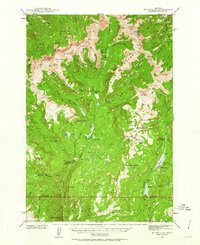 1940 Mt Wallace1963 Print · USGSPark County high country is documented here at the start of the 1940s, where national forest and park lands converge. Researchers can trace remote routes like the Poacher Trail and find isolated outposts such as Bull Moose Cabin and Hellroaring Ranger Station.3 unique versions available
 - 1942 Map of Cutoff Mtn, 1959 Print
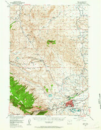
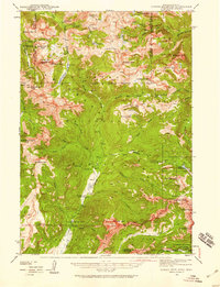 1942 Cutoff Mtn1959 Print · USGSThe Absaroka-Beartooth wilderness along the Montana-Wyoming border is captured here in the early 1940s. Researchers can trace the high-country trails and sites like the Independence Mine, Silver Tip Ranch, and the Cooke Ranger Sta.4 unique versions available
 - 1943 Map of Mt Wallace
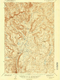 1943 Mt Wallace1943 Print · USGSThe Absaroka wilderness at the edge of Yellowstone comes to life in the late 1930s, showing a remote landscape of high basins and ranger outposts. Trace the early trails and lookouts of the era, from Hellroaring Ranger Station to the Bull Moose Cabin and Poacher Trail.3 unique versions available
 - 1944 Map of Cutoff Mtn
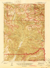 1944 Cutoff Mtn1944 Print · USGSThe northern gateway to Yellowstone and the high Absaroka wilderness are documented in the early 1940s, just as the park’s modern boundaries were being refined. Trace the historic Northeast Entrance, the remote Silver Tip Ranch, and the high-altitude Independence Mine.2 unique versions available
 - 1944 Map of Red Lodge, 1946 Print
 1944 Red Lodge1946 Print · USGSCarbon County’s coal and ranching economy is captured here in the mid-1940s, from the railhead at Red Lodge to the banks of the Clarks Fork Yellowstone River. Genealogists and industrial historians can trace the operations of the Smith Mine, the Ohio Oil Co Camp, and the rural Clear Creek Sch.3 unique versions available
 - 1947 Map of Bozeman, 1948 Print
 1947 Bozeman1948 Print · USGSBozeman and the surrounding mountain ranges are captured here just after the war, showing the vital rail and river networks of southwestern Montana. Genealogists and historians can trace routes to early settlements like Virginia City, Gallatin Gateway, and the mountain community of Jardine.
 - 1948 Map of Bozeman, 1951 Print
 1948 Bozeman1951 Print · USGSSouthern Montana in the late 1940s is shown as a high-country crossroads of rail lines and river headwaters. Genealogists and historians can trace old town sites like Virginia City and McLeod alongside the Northern Pacific and Milwaukee Road railroads.
 - 1949 Map of Pat O'Hara Mountain, 1952 Print
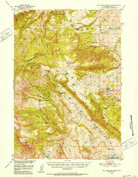 1949 Pat O'Hara Mountain1952 Print · USGSPark County ranching and wilderness are captured here in the late Forties, just as the Missouri River Basin project was shaping the region's development. Researchers can trace historic homesteads and outposts like Mooncrest Ranch, Pearson Cabin, and the remote Robbers Roost Cabin.5 unique versions available
 - 1949 Map of Cody, 1962 Print
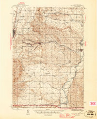
 1949 Cody1962 Print · USGSCody and the surrounding Park County landscape are documented here during the mid-twentieth century, showcasing a transition from mountain wilderness to irrigated ranchland. Researchers can locate numerous family estates like the Two Dot Ranch and significant infrastructure such as the Buffalo Bill Dam and Spirit Mountain Caverns.2 unique versions available
End of results
Showing maps 1-9 of 9
Top cities of Park County
Frequently asked questions
- What are the different types of historical maps available for Park County?
- What is the oldest map of Park County?
- Where can I purchase historical maps of Park County for my home or office?
- Where can I download high-res historical maps of Park County?
- Are there historical topographic maps available for Park County?
- Is there historical aerial imagery available for Park County?
- Where are historical maps of Park County sourced from?