1980s Maps of Park County, Wyoming
Explore 120 historic maps of Park County from the 1980s. These maps offer a rare glimpse into what life looked like during the 1980s — showing old roads, neighborhoods, homes, and landmarks that have changed or disappeared over time.
Whether you're researching your family's past, planning a metal detecting trip, or studying how Park County's landscape evolved across the 1980s, these high-resolution maps are a powerful tool for exploring the history of this region.
- Focus on a specific era: All maps on this page are from the 1980s, giving you a focused view of this time period.
- See what’s changed: Compare century-old streets, trails, and buildings to today's modern landscape using overlays and satellite layers.
- Research with precision: Use these maps for genealogy, historical research, land use analysis, or educational projects.
- View, download, or print: Maps are fully viewable online in high resolution, and can be downloaded or printed for your own records.
Start exploring Park County's history through authentic maps from the 1980s. This is your window into the past.
Park County, WY maps
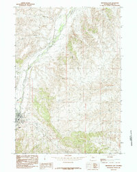
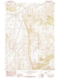
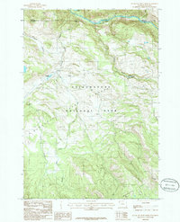
(120)- 1980 Map of Carter Mountain, 1982 Print
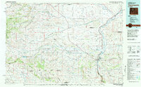
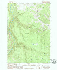
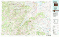 1980 Carter Mountain1982 Print · USGSPark County at the dawn of the 1980s reveals a high-country landscape where mountain wilderness meets energy extraction. Researchers can locate remote outposts like Irma, trace the Greybull River valley, and identify the footprint of the Pitchfork Oil Field or Sunshine Reservoir.3 unique versions available
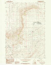
 - 1980 Map of Cody, 1982 Print
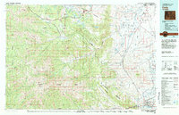 1980 Cody1982 Print · USGSThe Cody region in the early 1980s reveals a rugged wilderness of the Shoshone National Forest meeting the plains. Researchers can trace the Burlington Northern rail line and locate landmarks like Painter Mine and Buffalo Bill Reservoir.3 unique versions available
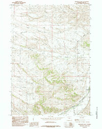
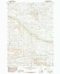
 - 1980 Map of Powell, 1982 Print
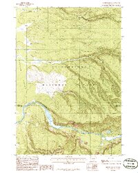
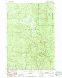
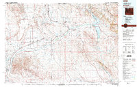 1980 Powell1982 Print · USGSThe Bighorn Basin in the 1980s shows a landscape where irrigation and rail transformed the high desert near the Montana border. Researchers can trace the path of the Burlington Northern line through historic stops like Garland, Frannie, and Deaver.
 - 1981 Map of Jackson Lake
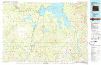
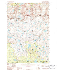
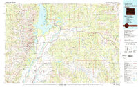 1981 Jackson Lake1981 Print · USGSGrand Teton National Park and its surrounding wilderness are captured here in the early eighties. Researchers can trace high-altitude peaks like Mount Moran down to valley landmarks such as Jackson Lake Lodge, Colter Bay Village, and the Jackson Hole Airport.2 unique versions available
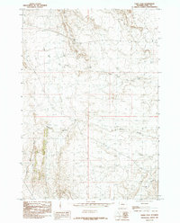
 - 1981 Map of Thermopolis, 1982 Print
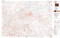
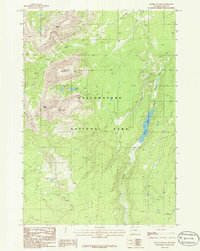
 1981 Thermopolis1982 Print · USGSCentral Wyoming in the early eighties shows a landscape of geothermal wonders and energy extraction. Trace the legacy of early settlements and industry near Hot Springs State Park, the rail lines of the Burlington Northern, and outposts like Gebo and Hamilton Dome.
 - 1982 Map of Yellowstone National Park South, 1983 Print
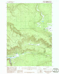
 1982 Yellowstone National Park South1983 Print · USGSThe southern reaches of Yellowstone and the Teton Wilderness are captured here in the early 1980s, showcasing a landscape of high plateaus and river headwaters. Trace the historic paths of the Two Ocean Pass Trail or locate remote outposts like Flagg Ranch and Grant Village.
 - 1982 Map of Basin, 1983 Print
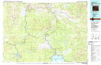
 1982 Basin1983 Print · USGSBig Horn and Park counties in the early eighties were defined by the high-desert benches and the vital waters of the Bighorn River. Researchers can trace the rail-and-river economy through the Burlington Northern line and locate local landmarks like the Eagle Mine or the Bird Reservation at Loch-Katrine.
 - 1983 Map of Yellowstone National Park North
 1983 Yellowstone National Park North1983 Print · USGSThe northern wilderness of Wyoming and Montana is captured here in the early eighties, documenting the geothermal landmarks and early visitor infrastructure. Trace the historic paths of the Howard Eaton Trail or locate park icons like Mammoth Hot Springs and the Lake Hotel.
 - 1985 Map of Meeteetse East
 1985 Meeteetse East1985 Print · USGSMeeteetse and the Greybull River valley are captured in the mid-eighties before modern development altered the rural landscape. Local historians can trace ranching landmarks like Sleepers Ranch and the family history associated with Cemetery Hill.
 - 1985 Map of Meeteetse West
 1985 Meeteetse West1985 Print · USGSThe Greybull River valley and the town of Meeteetse are shown in the mid-1980s, documenting the ranching landscape before modern development. Researchers can trace the drainage patterns of Meeteetse Rim and locate the Gaging Sta along the Greybull River.
 - 1985 Map of Sleepers Ranch
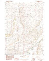 1985 Sleepers Ranch1985 Print · USGSPark County ranching and water rights come into focus during the mid-eighties as the Greybull River meets the Meeteetse Rim. Researchers can trace irrigation history along Dodge Ditch or locate the namesake Sleepers Ranch.
 - 1985 Map of Little Buffalo Basin
 1985 Little Buffalo Basin1985 Print · USGSThe Little Buffalo Basin and the Park-Hot Springs county line are shown in the mid-1980s as the regional energy industry flourished. Local researchers can locate the Little Buffalo Basin Camp, an Oil Field, and a remote Landing Strip.
 - 1985 Map of Iron Creek
 1985 Iron Creek1985 Print · USGSPark County, Wyoming, is captured in the mid-1980s as a landscape of high benches and vital water management. Researchers can trace irrigation networks from the Sunshine Reservoir and find family-named landmarks like Rice Bench and Greybull Bench.
 - 1985 Map of Elk Butte
 1985 Elk Butte1985 Print · USGSPark County during the mid-1980s reveals a high-plains landscape defined by the prominent Meeteetse Rim and isolated outposts. Researchers can trace land use through features like Oregon Camp, Coal Mine Gulch, and the network of drainages around Elk Butte.
 - 1985 Map of Oregon Basin
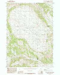
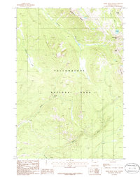
 1985 Oregon Basin1985 Print · USGSPark County, Wyoming, is captured in the late seventies and early eighties during a peak era of mineral and water management. Researchers can trace the industrial footprint of the Oregon Basin Field and find water features like Lake Katrine and the Cody Canal.
 - 1985 Map of Eagle Pass
 1985 Eagle Pass1985 Print · USGSPark County, Wyoming, during the mid-1980s is documented here through its distinct high-plains geography and drainage systems. Trace historical land use and geological landmarks through named features like Coal Mine Gulch, Oregon Coulee, and Eagle Pass.
 - 1986 Map of Amethyst Mountain
 1986 Amethyst Mountain1986 Print · USGSYellowstone's high country is captured here in the mid-eighties, centered on the geothermal basins and ridges east of the great canyon. Researchers can trace the winding Pack Trail past Amethyst Mountain or locate thermal features like Rainbow Springs.
 - 1986 Map of Mount Jackson
 1986 Mount Jackson1986 Print · USGSYellowstone's western interior is documented here in the mid-eighties, centered on the dramatic passage of the Madison River. Historians can trace the winding Pack Trail and identify high-country landmarks like Mount Jackson and Harlequin Lake.
 - 1986 Map of Cook Peak
 1986 Cook Peak1986 Print · USGSIn the mid-1980s, the high interior of Yellowstone was a landscape of remote peaks and alpine waterways. Researchers can trace the high-altitude Pack Trail past Observation Peak and down to the shores of Grebe Lake.
 - 1986 Map of Three Rivers Peak
 1986 Three Rivers Peak1986 Print · USGSYellowstone National Park's northwestern interior is captured in the mid-1980s, centered on the high hydrologic divide of the Gallatin Range. Researchers can trace the source of the Gallatin River at Gallatin Lake and navigate the high passes of Crowfoot Ridge and Bighorn Pass.
 - 1986 Map of Blacktail Deer Creek
 1986 Blacktail Deer Creek1986 Print · USGSYellowstone's northern backcountry comes into focus in the mid-1980s, documenting the rugged drainage of the Yellowstone River at the Montana Wyoming border. Trace primitive travel routes like the Pack Trail and locate natural landmarks including Wraith Falls and Phantom Lake.
 - 1986 Map of Mount Holmes
 1986 Mount Holmes1986 Print · USGSYellowstone National Park in the mid-1980s reveals a pristine wilderness of high summits and alpine drainages. Hikers and researchers can trace the elevations of Mount Holmes or follow the waters of Grizzly Lake and Indian Creek through the park's interior.
 - 1986 Map of Castle Mountain
 1986 Castle Mountain1986 Print · USGSThe high Beartooth range along the Montana and Wyoming border is shown here in the mid-1980s, just as these wilderness boundaries were being established. Hikers and explorers can trace remote routes like the Sierra Trail and Impasse Trail past landmarks like Sundance Glacier and Charlie Falls.2 unique versions available
 - 1986 Map of Madison Junction
 1986 Madison Junction1986 Print · USGSYellowstone's central river valleys are captured here in the mid-1980s, documenting the landscape where the Firehole and Gibbon rivers meet. Researchers can trace the layout of Madison Junction, locate the Monument Geyser Basin, and follow the Gibbon Canyon.
 - 1986 Map of Mary Lake
 1986 Mary Lake1986 Print · USGSYellowstone National Park in the mid-eighties was a landscape of high plateaus and remote backcountry trails. You can trace the path of the Pack Trail as it winds past Mary Lake and several Hot Springs along the Nez Perce Creek.
Showing maps 1-25 of 120
Top cities of Park County
Frequently asked questions
- What are the different types of historical maps available for Park County?
- What is the oldest map of Park County?
- Where can I purchase historical maps of Park County for my home or office?
- Where can I download high-res historical maps of Park County?
- Are there historical topographic maps available for Park County?
- Is there historical aerial imagery available for Park County?
- Where are historical maps of Park County sourced from?