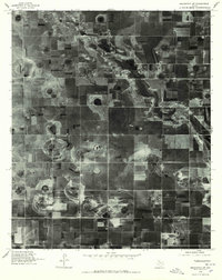
1976 Map of Abernathy SW
USGS Topo · Published 1978About this map
Blackwater Draw meanders across this High Plains landscape, its winding channel punctuating a vast patchwork of circular and rectangular agricultural fields. Produced from 1976 aerial photography, this orthophotoquad reveals the intricate textures of the Llano Estacado's surface, where hundreds of playa lakes or depression features appear as dark, varied shapes among the tillable land. In the southern portion of the sheet, the label Caldwell marks a boundary area, highlighting how regional divisions overlay the natural drainage patterns of the draw. This document provides a rare direct visual of land-use patterns and moisture retention in the soil before modern center-pivot irrigation and contemporary development altered the rural texture of Lubbock County.
Find a feature on this map
2 named features on this map. Tap any name to fly to it.
Don’t see what you’re looking for? This feature index may not catch every label — zoom into the map to look around manually.
Map Details
Editions of this 1976 Abernathy SW Map
This is the sole edition of this map. No revisions or reprints were ever made.
Other maps of this area

1954 · Lubbock
USGS Topo · 1:250,000

1954 · Brownfield
USGS Topo · 1:250,000

1956 · Shallowater
USGS Topo · 1:24,000

1956 · New Deal
USGS Topo · 1:24,000

1957 · Lubbock
USGS Topo · 1:62,500

1957 · Anton
USGS Topo · 1:62,500

1957 · Abernathy
USGS Topo · 1:62,500

1957 · Wolfforth
USGS Topo · 1:62,500

1958 · Brownfield
USGS Topo · 1:250,000

1962 · Brownfield
USGS Topo · 1:250,000