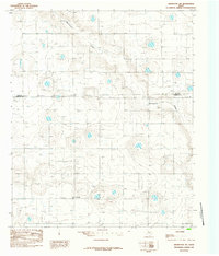
1985 Map of Abernathy SW
USGS Topo · Published 1985About this map
Caldwell sits in the southwestern reaches of this survey, where the agricultural landscape of the Texas Panhandle is defined by a vast network of irrigation and water management. Numerous points marked simply as Well pepper the grid-like property divisions, indicating the intensive groundwater reliance of the region during the mid-1980s. The most prominent natural drainage, Blackwater Draw, meanders across the upper half of the sheet, providing a topographic break in an otherwise consistent plain. Near the center of the draw, a Gravel Pit signifies local industrial activity. The map also delineates the jurisdictional boundary between Hale Co and Lubbock Co, capturing the rural infrastructure and land use patterns of these neighboring counties before late-century developments changed the local footprint.
Find a feature on this map
5 named features on this map. Tap any name to fly to it.
Don’t see what you’re looking for? This feature index may not catch every label — zoom into the map to look around manually.
Map Details
Editions of this 1985 Abernathy SW Map
This is the sole edition of this map. No revisions or reprints were ever made.
Other maps of this area

1954 · Lubbock
USGS Topo · 1:250,000

1954 · Brownfield
USGS Topo · 1:250,000

1956 · Shallowater
USGS Topo · 1:24,000

1956 · New Deal
USGS Topo · 1:24,000

1957 · Lubbock
USGS Topo · 1:62,500

1957 · Anton
USGS Topo · 1:62,500

1957 · Abernathy
USGS Topo · 1:62,500

1957 · Wolfforth
USGS Topo · 1:62,500

1958 · Brownfield
USGS Topo · 1:250,000

1962 · Brownfield
USGS Topo · 1:250,000