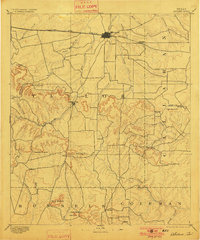
1892 Map of Abilene
USGS Topo · Published 1901About this map
Abilene sits at the northern edge of this West Texas survey, defined by its position along the Texas and Pacific Railway. At the turn of the century, the region was transitioning from a purely ranching frontier to a more structured agricultural and rail-connected economy. The landscape is characterized by a series of prominent peaks and gaps that served as critical landmarks for early travelers and settlers. South of the city, Buffalo Gap and Guion mark established communities positioned near the breaks in the hills, such as Cedar Gap and Lytle Gap. The intricate network of seasonal waterways, including Pecan Bayou and Jim Ned Creek, illustrates the drainage patterns through Taylor and Callahan counties. Distinctive terrain features like Steamboat Mountain, Bald Eagle Peak, and Table Mountain provide a clear view of the topographical relief that challenged early transportation routes.
Find a feature on this map
38 named features on this map. Tap any name to fly to it.
Don’t see what you’re looking for? This feature index may not catch every label — zoom into the map to look around manually.
Map Details
Editions of this 1892 Abilene Map
5 editions found
Other maps of this area

1887 · Coleman
USGS Topo · 1:125,000

1889 · Coleman
USGS Topo · 1:125,000

1890 · Abilene
USGS Topo · 1:125,000

1891 · Hayrick
USGS Topo · 1:125,000

1891 · Anson
USGS Topo · 1:125,000

1892 · Abilene
USGS Topo · 1:125,000

1892 · Ballinger
USGS Topo · 1:125,000

1892 · Albany
USGS Topo · 1:125,000

1893 · Albany
USGS Topo · 1:125,000

1893 · Roby
USGS Topo · 1:125,000