Loading...
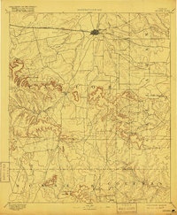
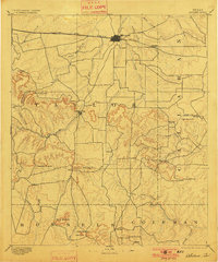
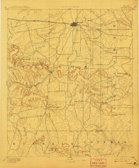
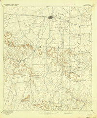
Loading map...1892 Map of Abilene
USGS Topo · Published 1916About this map
The settlement of Abilene serves as the primary rail hub on this late 19th-century survey, defined by the corridor of the Texas and Pacific Railway as it stretches across the northern territory. While the rail line anchors the northern plains near Elmdale, the southern half of the landscape is dominated by the dramatic breaks and mesas of the Callahan Divide. Historic paths through these uplands are marked by landmarks like Buffalo Gap, Cedar Gap, and Table Gap, which provided essential passage for early travelers and cattle.
Find a feature on this map
38 named features on this map. Tap any name to fly to it.
Don’t see what you’re looking for? This feature index may not catch every label — zoom into the map to look around manually.
Map Details
Date Portrayed1892
Date Published1916
PublisherU.S. Geological Survey
Map TypeTopographic
Scale1:125,000
Physical Dimensions16.3 x 19.8 inches
Editions of this 1892 Abilene Map
5 editions found

Historical Maps of Abilene Through Time
5 maps found


Featured Locations
Source Details
SourceU.S. Geological Survey
CopyrightPublic Domain