
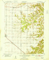
1947 Map of Adair
USGS Topo · Published 1981About this map
The Fourth Principal Meridian bisects this landscape on the border of McDonough and Fulton counties, where a highly developed network of rural schoolhouses and country churches defines the mid-century social geography. Small agrarian centers like Adair and New Philadelphia are linked by the Chicago Burlington and Quincy railroad, while Marietta sits to the northeast along the Toledo Peoria and Western line. This survey captures the region's educational density before the mid-century era of school consolidation, preserving the locations of the Rich, Pilot Grove, Shinn, and Buckwheat schools. The terrain transitions from the upland flats of Mound and New Salem townships into the dissected drainage basins of Barker and Badger creeks, where the Barker Ch and Temple Cem serve the surrounding farming community.
Find a feature on this map
25 named features on this map. Tap any name to fly to it.
Don’t see what you’re looking for? This feature index may not catch every label — zoom into the map to look around manually.
Map Details
Editions of this 1947 Adair Map
This is the sole edition of this map. No revisions or reprints were ever made.
Other maps of this area

1912 · Macomb
USGS Topo · 1:62,500

1914 · Macomb
USGS Topo · 1:62,500

1915 · Avon
USGS Topo · 1:62,500

1916 · Good Hope
USGS Topo · 1:62,500

1918 · Vermont
USGS Topo · 1:62,500

1918 · Good Hope
USGS Topo · 1:62,500

1921 · Vermont
USGS Topo · 1:62,500

1944 · Avon
USGS Topo · 1:62,500

1947 · Vermont
USGS Topo · 1:24,000
1948 · Adair
USGS Topo · 1:24,000