
1963 Map of Adams
USGS Topo · Published 1966About this map
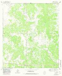
The O Harrow Oil Field and various Oil Wells define the industrial landscape of this Schleicher County terrain in the early 1960s. Located north of North Valley, the area is characterized by a network of drainage systems including Poor Hollow, Otto Hollow, and East Poor Hollow. The presence of an extensive Aboveground Pipeline cutting across the landscape highlights the mid-century infrastructure required to transport petroleum from remote Texas fields. Small-scale extraction is further evidenced by numerous Gravel Pits and scattered Gas Wells throughout the territory. The small settlement of Adams serves as a local point of reference within this complex network of draws and ridges, which include the prominent Montgomery rise. This survey illustrates the transition from traditional ranching lands to an active energy-production corridor.
Find a feature on this map
13 named features on this map. Tap any name to fly to it.
Don’t see what you’re looking for? This feature index may not catch every label — zoom into the map to look around manually.
Map Details
Editions of this 1963 Adams Map
2 editions found
Other maps of this area

1892 · San Angelo
USGS Topo · 1:125,000

1893 · Fort McKavett
USGS Topo · 1:125,000

1954 · Sonora
USGS Topo · 1:250,000

1954 · San Angelo
USGS Topo · 1:250,000

1958 · Sonora
USGS Topo · 1:250,000

1958 · San Angelo
USGS Topo · 1:250,000

1963 · Adams NW
USGS Topo · 1:24,000

1963 · Adams SE
USGS Topo · 1:24,000

1963 · Adams SW
USGS Topo · 1:24,000

1965 · San Angelo
USGS Topo · 1:250,000