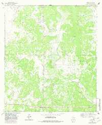
1963 Map of Adams
USGS Topo · Published 1982About this map
Poor Hollow and East Poor Hollow carve through the landscape of central Texas in this 1960s study, which highlights an economy defined by natural resource extraction. The presence of a dedicated Oil Field and numerous Gas Wells and Oil Well sites indicates the region's mid-century reliance on the petroleum industry. While the terrain is dominated by these industrial sites and extensive Gravel Pit operations, small clusters of habitation like Adams and Montgomery provide evidence of the local ranching and work-crew settlements that supported the area. The documentation includes fine details such as fence lines and small stock tanks, reflecting the parceling of the land for agricultural and mineral use. This survey, later updated in the early 1980s, captures the transition from traditional ranching toward more intensive industrial development in North Valley.
Find a feature on this map
10 named features on this map. Tap any name to fly to it.
Don’t see what you’re looking for? This feature index may not catch every label — zoom into the map to look around manually.
Map Details
Editions of this 1963 Adams Map
2 editions found
Other maps of this area

1892 · San Angelo
USGS Topo · 1:125,000

1893 · Fort McKavett
USGS Topo · 1:125,000

1954 · Sonora
USGS Topo · 1:250,000

1954 · San Angelo
USGS Topo · 1:250,000

1958 · Sonora
USGS Topo · 1:250,000

1958 · San Angelo
USGS Topo · 1:250,000

1963 · Adams
USGS Topo · 1:24,000

1963 · Adams NW
USGS Topo · 1:24,000

1963 · Adams SE
USGS Topo · 1:24,000

1963 · Adams SW
USGS Topo · 1:24,000