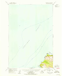
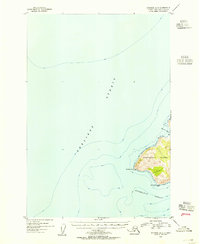
1954 Map of Afognak B-4
USGS Topo · Published 1955About this map
Shelikof Strait dominates this 1954 maritime survey, which charts the rugged northwestern coast of Afognak Island during a period of transition in the Alaska Territory. The map highlights the intersection of land and sea where the Chugach National Forest meets the deep waters of the Gulf of Alaska. A solitary Cabin at Cape Paramanof suggests the seasonal presence of trappers, fishermen, or surveyors in an otherwise unpopulated landscape. The intricate topography around Paramanof Bay and Malina Bay reveals a coastline of steep slopes and high peaks, where terrestrial life is largely confined to the narrow fringes of the shore. Compiled from USC&GS hydrographic charts and 1952 aerial photography, this sheet provides a detailed look at the island's natural harbors and rocky headlands such as Tanaak Cape before the statehood era changed the region's administrative landscape.
Find a feature on this map
8 named features on this map. Tap any name to fly to it.
Don’t see what you’re looking for? This feature index may not catch every label — zoom into the map to look around manually.
Map Details
Editions of this 1954 Afognak B-4 Map
This is the sole edition of this map. No revisions or reprints were ever made.
Other maps of this area
1951 · Afognak C-5
USGS Topo · 1:63,360

1952 · Afognak
USGS Topo · 1:250,000

1952 · Afognak A-4
USGS Topo · 1:63,360

1952 · Afognak A-3
USGS Topo · 1:63,360
1952 · Afognak A-5
USGS Topo · 1:63,360
1952 · Afognak B-4
USGS Topo · 1:63,360

1953 · Afognak A-4
USGS Topo · 1:63,360
1953 · Afognak A-5
USGS Topo · 1:63,360

1954 · Afognak B-3
USGS Topo · 1:63,360
1954 · Afognak A-3
USGS Topo · 1:63,360