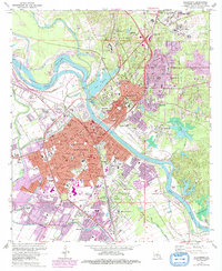
1972 Map of Alexandria
USGS Topo · Published 1992About this map
The Red River corridor defines the geography of this central Louisiana hub, separating the urban centers of Alexandria and Pineville. This 1970s landscape is densely packed with institutional and educational landmarks, from the expansive grounds of Camp Beauregard in the northeast to the VA Hospital and Louisiana College across the river. The map reveals the intricate network of the Missouri Pacific and Texas and Pacific railroads that historically drove the regional economy, alongside the complex levee systems and drainage canals like the Diversion Channel protecting the low-lying settlements. Neighborhoods such as Anandale, Samtown, and Smithville are shown in detail, including numerous parochial and public institutions like Our Lady of Prompt Succor Sch and Peabody High Sch. The map also documents the significant presence of the Alexandria National Cem and the Central Louisiana State Hospital, reflecting the city's long-standing role as a center for state and federal services.
Find a feature on this map
106 named features on this map. Tap any name to fly to it.
Don’t see what you’re looking for? This feature index may not catch every label — zoom into the map to look around manually.
Map Details
Editions of this 1972 Alexandria Map
4 editions found
Other maps of this area

1932 · Boyce NE
USGS Topo · 1:31,680

1935 · Lecompte
USGS Topo · 1:62,500

1941 · Alexandria
USGS Topo · 1:62,500

1941 · Boyce
USGS Topo · 1:62,500

1945 · Boyce SE
USGS Topo · 1:31,680

1949 · Boyce SE
USGS Topo · 1:31,680

1953 · Alexandria
USGS Topo · 1:250,000

1955 · Alexandria
USGS Topo · 1:250,000

1956 · Forest Hill
USGS Topo · 1:62,500

1956 · Boyce
USGS Topo · 1:62,500