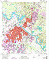
1972 Map of Alexandria
USGS Topo · Published 1992About this map
The Red River divides the urban landscape of Central Louisiana, separating the city of Alexandria from Pineville during a period of significant mid-to-late century expansion. The map details a dense institutional presence north of the river, anchored by the Central Louisiana State Hospital, the VA Hospital, and the sprawling grounds of Camp Beauregard. This area serves as a regional hub for healthcare and military infrastructure, balanced by residential growth in neighborhoods like Lee Heights and Smithville.
Find a feature on this map
103 named features on this map. Tap any name to fly to it.
Don’t see what you’re looking for? This feature index may not catch every label — zoom into the map to look around manually.
Map Details
Editions of this 1972 Alexandria Map
4 editions found
Other maps of this area

1932 · Boyce NE
USGS Topo · 1:31,680

1935 · Lecompte
USGS Topo · 1:62,500

1941 · Alexandria
USGS Topo · 1:62,500

1941 · Boyce
USGS Topo · 1:62,500

1945 · Boyce SE
USGS Topo · 1:31,680

1949 · Boyce SE
USGS Topo · 1:31,680

1953 · Alexandria
USGS Topo · 1:250,000

1955 · Alexandria
USGS Topo · 1:250,000

1956 · Forest Hill
USGS Topo · 1:62,500

1956 · Boyce
USGS Topo · 1:62,500