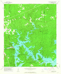
1961 Map of Allatoona Dam
USGS Topo · Published 1963About this map
Allatoona Reservoir dominates this early 1960s landscape, with its dendritic shoreline reaching deep into the valleys of Stamp Creek and Illinois Creek. The newly formed reservoir transformed the local topography following the construction of the Allatoona Dam and its associated Powerplant on the Etowah River. This era of recreational development is evidenced by the concentration of youth camps and public lands, including the Johnson Girl Scout Camp, Allatoona Boy Scout Camp, and Red Top Mountain State Park.
Find a feature on this map
56 named features on this map. Tap any name to fly to it.
Don’t see what you’re looking for? This feature index may not catch every label — zoom into the map to look around manually.
Map Details
Editions of this 1961 Allatoona Dam Map
4 editions found
Other maps of this area

1890 · Cartersville
USGS Topo · 1:125,000

1891 · Cartersville
USGS Topo · 1:125,000

1896 · Cartersville
USGS Topo · 1:125,000

1906 · Stilesboro
USGS Topo · 1:62,500

1907 · Acworth
USGS Topo · 1:62,500

1908 · Stilesboro
USGS Topo · 1:62,500

1909 · Acworth
USGS Topo · 1:62,500

1941 · Adairsville
USGS Topo · 1:62,500

1944 · Adairsville
USGS Topo · 1:62,500

1947 · Waleska
USGS Topo · 1:62,500