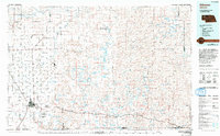
1985 Map of Alliance
USGS Topo · Published 1993About this map
Alliance serves as the primary hub of this High Plains landscape in the mid-1980s, where the Burlington Northern railroad corridor dictates the placement of small communities like Antioch, Lakeside, Ellsworth, and Bingham. The transition from the structured township grids of western Box Butte County into the fluid, lake-potted terrain of the Sandhills to the east is striking. This eastern portion is defined by a dense concentration of water bodies including Jesse Lake, School Section Lake, and the Chain of Lakes, many of which sit within valleys such as Survey Valley and Hospital Valley. Landforms like Wild Horse Butte and Marron Hill rise above the flats, providing distinct landmarks in an area dominated by cattle ranching and sparse settlement. The Smith Lake State Wildlife Management Area and Alliance Municipal Airport mark significant public and industrial footprints in the region.
Find a feature on this map
101 named features on this map. Tap any name to fly to it.
Don’t see what you’re looking for? This feature index may not catch every label — zoom into the map to look around manually.
Map Details
Editions of this 1985 Alliance Map
2 editions found
Other maps of this area

1896 · Browns Creek
USGS Topo · 1:125,000

1898 · Camp Clarke
USGS Topo · 1:125,000

1899 · Browns Creek
USGS Topo · 1:125,000

1946 · Berea Creek East
USGS Topo · 1:24,000

1947 · Alliance
USGS Topo · 1:24,000

1947 · Bronco Lake
USGS Topo · 1:24,000

1947 · Box Butte NE
USGS Topo · 1:24,000

1947 · Box Butte
USGS Topo · 1:24,000

1947 · Box Butte NW
USGS Topo · 1:24,000

1948 · Hemingford
USGS Topo · 1:24,000