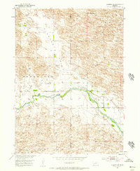
1952 Map of Almeria NW
USGS Topo · Published 1957About this map
Pleasant Valley and the surrounding Nebraska sandhills define this mid-century landscape along the Blaine and Loup county line. The North Loup River meanders across the center of the sheet, bordered by an irrigation system of Canals and an Aband Canal, showing the efforts to manage water in this semi-arid region. Rural life in the early 1950s is anchored by localized centers of community and education, including the Church of God and several district schools such as Pleasant Valley Sch, West End Sch, and School No 15. The terrain is marked by distinct valleys and ridges, including Bloody, Sawyer, and Dry Valley, reflecting the complex topography north of the river. Large agricultural holdings like the Peterson Ranch indicate the scale of ranching operations that historically sustained this portion of the Missouri River Basin.
Find a feature on this map
15 named features on this map. Tap any name to fly to it.
Don’t see what you’re looking for? This feature index may not catch every label — zoom into the map to look around manually.
Map Details
Editions of this 1952 Almeria NW Map
4 editions found
Other maps of this area

1952 · Brewster
USGS Topo · 1:24,000

1952 · Almeria NE
USGS Topo · 1:24,000

1952 · Almeria NW
USGS Topo · 1:24,000

1952 · Almeria SW
USGS Topo · 1:24,000

1952 · Brewster SE
USGS Topo · 1:24,000

1952 · Almeria
USGS Topo · 1:24,000

1955 · Broken Bow
USGS Topo · 1:250,000

1955 · O'Neill
USGS Topo · 1:250,000

1956 · Broken Bow
USGS Topo · 1:250,000

1959 · O'Neill
USGS Topo · 1:250,000