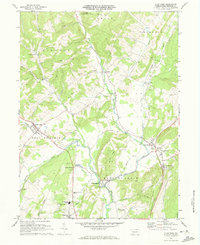
1971 Map of Alum Bank
USGS Topo · Published 1973This historical map portrays the area of Alum Bank in 1971, primarily covering Bedford County. Featuring a scale of 1:24000, this map provides a highly detailed snapshot of the terrain, roads, buildings, counties, and historical landmarks in the Alum Bank region at the time. Published in 1973, it is one of 3 known editions of this map due to revisions or reprints.
Find a feature on this map
44 named features on this map. Tap any name to fly to it.
Don’t see what you’re looking for? This feature index may not catch every label — zoom into the map to look around manually.
Map Details
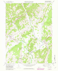
Editions of this 1971 Alum Bank Map
3 editions found
Historical Maps of Alum Bank Through Time
20 maps found

1908 Bedford
Bedford County, PA

1910 Bedford
Bedford County, PA

1927 Clearville
Bedford County, PA

1931 Clearville
Bedford County, PA

1944 Clearville
Bedford County, PA

1950 Artemas
Bedford County, PA

1967 Beans Cove
Bedford County, PA

1967 Buffalo Mills
Bedford County, PA

1967 Clearville
Bedford County, PA

1967 Mench
Bedford County, PA

1968 Chaneysville
Bedford County, PA

1968 Everett East
Bedford County, PA

1968 Everett West
Bedford County, PA

1968 New Enterprise
Bedford County, PA

1971 Alum Bank
Bedford County, PA

1971 Bedford
Bedford County, PA

1971 Ogletown
Bedford County, PA

1977 Ogletown
Bedford County, PA

1994 Everett East
Bedford County, PA

1994 Mench
Bedford County, PA
Featured Locations
- East Saint Clair Township, PA
- Pavia Township, PA
- King Township, PA
- Saint Clairsville, PA
- Churchville, East Saint Clair Township