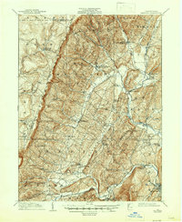
1910 Map of Bedford
USGS Topo · Published 1947About this map
The Allegheny Mountains dominate the western portion of this 1908 survey, where steep ridges separate small upland farming communities and isolated post offices. The landscape transitions from the high peaks of Pot Ridge down to the fertile valleys of Dunnings Creek and the Raystown Branch Juniata River. This era shows a dense network of local education, with numerous one-room schoolhouses such as the Eight Square School, Rocklick School, and Centennial School serving the townships of Napier and East St Clair.
Find a feature on this map
72 named features on this map. Tap any name to fly to it.
Don’t see what you’re looking for? This feature index may not catch every label — zoom into the map to look around manually.
Map Details
Editions of this 1910 Bedford Map
4 editions found
Other maps of this area

1900 · Everett
USGS Topo · 1:62,500

1902 · Everett
USGS Topo · 1:62,500

1902 · Ebensburg
USGS Topo · 1:62,500

1902 · Hollidaysburg
USGS Topo · 1:62,500

1903 · Hollidaysburg
USGS Topo · 1:62,500

1904 · Ebensburg
USGS Topo · 1:62,500

1904 · Johnstown
USGS Topo · 1:62,500

1907 · Johnstown
USGS Topo · 1:62,500

1908 · Bedford
USGS Topo · 1:62,500

1910 · Bedford
USGS Topo · 1:62,500