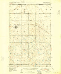
1948 Map of Ambrose
USGS Topo · Published 1948About this map
The settlement of Ambrose serves as the focal point of this late-1940s survey of Divide County, positioned just south of the Canada United States border. The town's grid is defined by its relationship with the Minneapolis St Paul and Sault Ste Marie railroad, which cuts east-to-west across the plains. This era captures the rural social infrastructure of the Blooming Prairie region, where distance was measured by the placement of local institutions like School No 1 and School No 8.
Find a feature on this map
16 named features on this map. Tap any name to fly to it.
Don’t see what you’re looking for? This feature index may not catch every label — zoom into the map to look around manually.
Map Details
Editions of this 1948 Ambrose Map
3 editions found
Other maps of this area

1948 · Crosby SW
USGS Topo · 1:24,000

1948 · Ambrose
USGS Topo · 1:24,000

1948 · Crosby
USGS Topo · 1:24,000

1948 · Crosby SE
USGS Topo · 1:24,000

1950 · Crosby
USGS Topo · 1:62,500

1953 · Williston
USGS Topo · 1:250,000

1957 · Williston
USGS Topo · 1:250,000
1983 · Colgan East
USGS Topo · 1:24,000
1983 · Colgan SE
USGS Topo · 1:24,000

1984 · Crosby
USGS Topo · 1:100,000