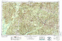
1957 Map of Andalusia
USGS Topo · Published 1957This historical map portrays the area of Andalusia in 1957, primarily covering Covington County as well as portions of Washington County, Mobile County, Crenshaw County, Escambia County, Montgomery County, Conecuh County, Baldwin County, Pike County, Wilcox County, Lowndes County, Geneva County, Clarke County, Monroe County, Marengo County, Butler County, and Coffee County. Featuring a scale of 1:250000, this map provides a highly detailed snapshot of the terrain, roads, buildings, counties, and historical landmarks in the Andalusia region at the time. Published in 1957, it is the sole known edition of this map.
Find a feature on this map
32 named features on this map. Tap any name to fly to it.
Don’t see what you’re looking for? This feature index may not catch every label — zoom into the map to look around manually.
Map Details
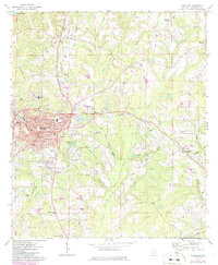
Editions of this 1957 Andalusia Map
This is the sole edition of this map. No revisions or reprints were ever made.
Historical Maps of Alberton Through Time
4 maps found