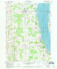
1959 Map of Andover
USGS Topo · Published 1971About this map
The expansive Pymatuning Reservoir dominates the eastern landscape of this Ashtabula County survey, straddling the state line where the North Shenango River and South Shenango River meet. A prominent Causeway connects the Ohio shore to Espyville in Pennsylvania, bisecting the waters near Stocker Island. The village of Andover serves as a central hub, where the Penn Central tracks cross through a grid of residential streets and local landmarks like the Pilgrim Ch and Maple Grove Cem.
Find a feature on this map
44 named features on this map. Tap any name to fly to it.
Don’t see what you’re looking for? This feature index may not catch every label — zoom into the map to look around manually.
Map Details
Editions of this 1959 Andover Map
4 editions found
Other maps of this area

1905 · Andover
USGS Topo · 1:48,000

1906 · Linesville
USGS Topo · 1:62,500

1907 · Andover
USGS Topo · 1:62,500

1907 · Kinsman
USGS Topo · 1:62,500

1908 · Shenango
USGS Topo · 1:62,500

1908 · Linesville
USGS Topo · 1:62,500

1950 · Cleveland
USGS Topo · 1:250,000

1956 · Cleveland
USGS Topo · 1:250,000

1958 · Greensville West
USGS Topo · 1:24,000

1959 · Hartstown
USGS Topo · 1:24,000