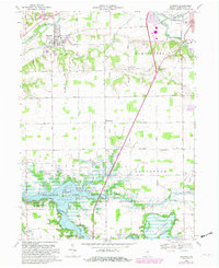
1969 Map of Andrews
USGS Topo · Published 1982About this map
Andrews occupies the northern bank of the Wabash River in this 1969 survey, revised in 1981 to show the significant impact of the Salamonie Lake reservoir project. The landscape is a transition between the established river town and the expansive floodwaters that now cover a portion of southern Polk township. To the south, the Salamonie River winds through the Heineys Bend area, surrounded by new recreational and conservation zones like the State Wildlife Management Area and Lost Bridge State Recreation Area. Genealogists will find historical continuity in the numerous rural burial grounds preserved around the edges of the water, including Riverside Cem and the Monument City Memorial Cem. Transportation is anchored by the Norfolk and Western railroad and U.S. 24, which connect the small clusters of Harlansburg and Lancaster to the wider region.
Find a feature on this map
45 named features on this map. Tap any name to fly to it.
Don’t see what you’re looking for? This feature index may not catch every label — zoom into the map to look around manually.
Map Details
Editions of this 1969 Andrews Map
3 editions found
Other maps of this area

1950 · Lagro
USGS Topo · 1:24,000

1950 · Andrews
USGS Topo · 1:24,000

1950 · Warren
USGS Topo · 1:24,000

1950 · Mount Etna
USGS Topo · 1:24,000

1951 · Mount Etna
USGS Topo · 1:24,000

1951 · Andrews
USGS Topo · 1:24,000

1951 · Lagro
USGS Topo · 1:24,000

1952 · Warren
USGS Topo · 1:24,000

1952 · Majenica
USGS Topo · 1:24,000

1953 · La Fontaine
USGS Topo · 1:24,000